Mountain refuge Bivouac Fisso "Money"

We have it listed in the app!


            Mountain refuge Bivouac Fisso "Money" in bivacco money, pont de fietselin, valmianaz, cogne, valle de aosta, 11012, italia
Five orange stars in a horizontal row representing a five-star rating.

Bivouac Fisso "Money"

Lat: 45.541xxx – Lon: 7.342xxx
📍 bivacco money, pont de fietselin, valmianaz, cogne, valle de aosta, 11012, italia
Bivouac Fisso "Money"

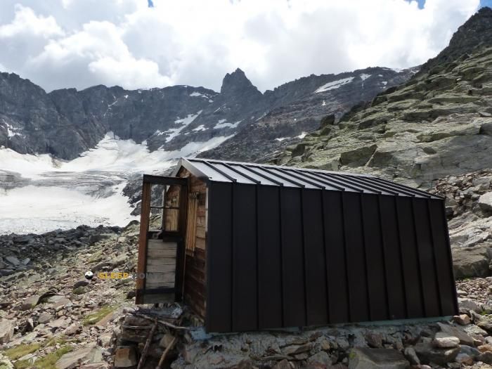
With a privileged location in bivacco money, pont de fietselin, valmianaz, cogne, valle de aosta, 11012, italia, the Bivouac Fisso "Money" refuge awaits you at 2872 meters of altitude. Note its position (45.541, 7.342) before starting your route through the mountain range or massif.

See more
See more
Usuario

Lucas Martinez

Premium user

Live weather: Bivouac Fisso "Money"

Attention hikers heading to Bivouac Fisso "Money": current conditions are 4.6°C (feels like 0.6°C due to 3.7 km/h wind). Beware of gusts up to 14 km/h. Snow level at 3960 m, UV index at 0, and an expected high of 5.3°C.
Temperature

4.6°C

Feels like: 0.6°C
Wind

3.7 km/h

Gusts: 14 km/h
Freezing level 0°

3960 m

Snow line
Sky & UV

UV 0

Clouds: 100%

Next 48 hours evolution

7-day forecast

04/06
5.3° -0.2°
7.9 mm 13.4 km/h UV máx: 5.7
05:43 21:14
05/06
4.1° -2.5°
0.2 mm 14.9 km/h UV máx: 8
05:43 21:15
06/06
8.1° 1.2°
0 mm 14.8 km/h UV máx: 6.4
05:42 21:15
07/06
10.5° 1.3°
0 mm 8.9 km/h UV máx: 8.15
05:42 21:16
08/06
10.2° 3.3°
3.3 mm 12.7 km/h UV máx: 7.75
05:41 21:17
09/06
9.7° 2.1°
0 mm 17.4 km/h UV máx: 7.7
05:41 21:17
10/06
8.6° -0.3°
0 mm 13.8 km/h UV máx: 6.7
05:41 21:18

The high sector of Cogne quickly enters the high mountain environment: wide terrain, glacial relief and a sense of isolation of the environment of the Grand Paradiso National Park . At almost 2,900 meters, the landscape no longer responds to a smaller excursion, but to a day that requires regular rhythm, time change and a certain release on alpine terrain. In this area of the Aosta Valley, above the routes that go back to the valley from Lillaz and Valmianaz, the passage to hills and cords links with known routes of journey, especially the High Via 2 which happens relatively close in several stages. Local connections to other mountain vivacs and trails also appear, something useful for anyone who proposes a linear route or a long day with alternatives.

Bivouac Fisso "Money" , in the term of Cogne and at 2872 m, it fits mainly as support to plan with caution a ascension or a journey in this sector of the massif. The nearby presence of summits such as Gran Serra, Herbetet or Punta di Cresole confirms the alpine character of the environment, although it is appropriate to understand it more as a geographical reference than as automatic access to cimas. There are no close data to provide water in the vicinity: the registered sources are several kilometres away, so water autonomy must be resolved before reaching height. No internal conditions or equipment are detailed here, so the decision to use this free shelter should be made with margin, sufficient material and refined weather forecast, especially if it is raised as a point of passage on a long high mountain day.

Hiking routes from the refuge

AV2

Alta Via n. 2 della Valle d'Aosta - Tappa 10

↔ 14.000 km
AVC

Alta Via Canavesana

↔ Variable distance
22E

Sentiero 22E Bivacco Martinotti

↔ Variable distance
13CL

Itinerario 13 Cascate di Lillaz

↔ Variable distance
AV2

Alta Via n. 2 della Valle d'Aosta - Tappa 9

↔ 8.220 km
AV2

Alta Via n. 2 della Valle d'Aosta - Tappa 8

↔ 17.000 km
Local

Schiaroglio-Moncimur

↔ 11.1 km
17A

Sentiero Natura

↔ Variable distance

Nearby peaks

Herbetet

3778 m
Lat: 45.5445 Lon: 7.2738

Punta dell'Inferno

3393 m
Lat: 45.5693 Lon: 7.2769

Gran Serra

3552 m
Lat: 45.5562 Lon: 7.2849

Becca di Montandayné

3838 m
Lat: 45.5324 Lon: 7.27

Cresta Gastaldi

3894 m
Lat: 45.5141 Lon: 7.2753

Punta di Ceresole

3777 m
Lat: 45.5131 Lon: 7.2852

Testa della Tribolazione

3642 m
Lat: 45.5163 Lon: 7.2977

Testa di Valnontey

3562 m
Lat: 45.5175 Lon: 7.3014

Nearby water fountains

Fuente

4.41 Km
Lat: 45.5175 Lon: 7.3014

Fuente

4.65 Km
Lat: 45.5175 Lon: 7.3014

Fuente

4.7 Km
Lat: 45.5175 Lon: 7.3014

Fuente

4.72 Km
Lat: 45.5175 Lon: 7.3014

Fuente

5.05 Km
Lat: 45.5175 Lon: 7.3014

Fuente

5.11 Km
Lat: 45.5175 Lon: 7.3014

Fuente

5.25 Km
Lat: 45.5175 Lon: 7.3014

Fuente

5.49 Km
Lat: 45.5175 Lon: 7.3014
FAQ

Frequently asked questions

Pregunta frecuente
At what exact altitude is the Bivouac Fisso "Money" refuge located?
The Bivouac Fisso "Money" refuge is located at an altitude of 2872 meters above sea level, in the natural surroundings of bivacco money, pont de fietselin, valmianaz, cogne, valle de aosta, 11012, italia.
Pregunta frecuente
What are the GPS coordinates of the Bivouac Fisso "Money" refuge?
To locate the Bivouac Fisso "Money" refuge on your GPS or map, use the following coordinates: Latitude 45.541 and Longitude 7.342.
Pregunta frecuente
Is it necessary to carry a GPS to reach the Bivouac Fisso "Money" refuge?
It is always highly recommended to carry a GPS device, a route track, or a topographic map in the mountains. You can use the coordinates 45.541, 7.342 to locate this refuge precisely.
More areas

Other areas

Collaborative

Together we improve

image

Send your photos

You can upload photos of shelters and update their status so other users know if they can go there.

Get started
Get started
image

Rate the shelter

Leave your comments to rate the shelter’s condition. In the mountains, we look after each other.

Get started
Get started
image

Add new ones

Did we miss any? Publish the shelters you know so everyone can use them.

Get started
Get started
Download for free from the Apple App Store and Play Store.

Download the app and start looking for the shelter of your next adventure

Aplicación móvil para encontrar refugios de montaña donde dormir
Aplicación móvil para encontrar refugios de montaña donde dormir.
Mapa interactivo de refugios de montaña en los Pirineos dentro de la app
Mapa de refugios de montaña para senderismo y trekking en la app.
Pantalla con información de refugio de montaña con altitud capacidad y servicios
Pantalla con información de refugio de montaña con altitud capacidad y servicios.
Detalles de refugio de montaña con servicios y meteorología en aplicación móvil
Detalles de refugio de montaña con servicios y meteorología en aplicación móvil.
Aplicación para explorar refugios de montaña mediante mapa interactivo
Aplicación para explorar refugios de montaña mediante mapa interactivo.
Ficha completa de refugio de montaña con opiniones y servicios
Ficha completa de refugio de montaña con opiniones y servicios.
Información detallada de refugio en app para montañeros
Información detallada de refugio en app para montañeros.
Listado de refugios de montaña para senderismo y trekking
Listado de refugios de montaña para senderismo y trekking.
Explorar refugios de montaña desde una aplicación móvil
Explorar refugios de montaña desde una aplicación móvil.