Mountain refuge Refuge Pontese

We have it listed in the app!


            Mountain refuge Refuge Pontese in rifugio pontese, senza tracce, su ghiacciaio, locana, turín, piamonte, 10081, italia
Five orange stars in a horizontal row representing a five-star rating.

Refuge Pontese

Lat: 45.496xxx – Lon: 7.369xxx
📍 rifugio pontese, senza tracce, su ghiacciaio, locana, turín, piamonte, 10081, italia
Refuge Pontese

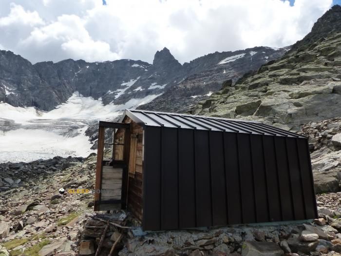
Located at 2217 m above sea level, the Refuge Pontese refuge is a true haven of peace in rifugio pontese, senza tracce, su ghiacciaio, locana, turín, piamonte, 10081, italia. Connect with nature and use its coordinates (45.496, 7.369) to guide your steps to its door.

See more
See more
Usuario

Lucas Martinez

Premium user

Live weather: Refuge Pontese

Alpine weather summary for Refuge Pontese: temperature at 6.7°C, feels like 3.3°C. Wind at 6.2 km/h with peaks of 14.8 km/h. UV index at 0 and freezing altitude at 3920 m. Maximum temperatures of 9.4°C in the coming hours.
Temperature

6.7°C

Feels like: 3.3°C
Wind

6.2 km/h

Gusts: 14.8 km/h
Freezing level 0°

3920 m

Snow line
Sky & UV

UV 0

Clouds: 91%

Next 48 hours evolution

7-day forecast

04/06
9.4° 6.5°
9.7 mm 14.2 km/h UV máx: 4.9
05:43 21:14
05/06
9.6° 3.9°
0 mm 13.6 km/h UV máx: 7.65
05:43 21:14
06/06
12.8° 6.2°
0.03 mm 10.8 km/h UV máx: 5.5
05:42 21:15
07/06
14.1° 7.4°
0 mm 11.7 km/h UV máx: 7.8
05:42 21:16
08/06
14.9° 9.4°
1.2 mm 12.3 km/h UV máx: 7.5
05:42 21:16
09/06
14.6° 7.7°
0 mm 15.6 km/h UV máx: 7.4
05:41 21:17
10/06
11.3° 5.4°
0 mm 16 km/h UV máx: 5.15
05:41 21:18

Field reading

Refugee Pontese is located in the Locana , in Piedmont within the scope of the Grand Paradiso National Park , 2217 meters. The reference of the mapping places it in mountain terrain and very close to a glacier area, a useful data to understand the character of the place: exposed environment, rapid changes of visibility and a weather that can harden the day even without great distances. In this environment, the shelter works mainly as a support to reorganize the march, shorten a retreat or divide a journey when time gets worse.

Connections and utility

Its position fits well with walking paths rather than a simple isolated excursion. The Alta Via Canavesana and the historical Mulattiera reale help to place it within a network of routes where it is appropriate to read the map and the relief before linking valleys or hills. It also appears in the stage environment of the GTA , so it may be of interest to those who cross this part of the Graian Alps and need an intermediate point in an area where land and time command more than the apparent closeness between references.

The nearby relief reinforces that alpine character. Summits like Torre del Gran San Pietro , Roccia Viva or Punta d'Ondezana they raise a horizon of three thousand and edges that explains the general exposure of the sector, although their presence should not be automatically interpreted as simple access to ascension. Rather they serve to understand that the shelter is left in a high mountain basin where orientation, residual snow or fog can make the progression very much conditional.

For logistics, there is a source pointed at about 16 meters, a favourable data but that in the mountain it is always necessary to verify on the ground. If it is proposed as a free shelter or as a point of mountain autonomy, it is reasonable to arrive with water margin, shelter and capacity to manage a change of plan. In unstable days, its value is precisely to provide a fixed reference within an isolated sector, where withdrawal in time is often more important than to hasten the itinerary.

Hiking routes from the refuge

Local

Mulattiera reale

↔ Variable distance
AVC

Alta Via Canavesana

↔ Variable distance
22E

Sentiero 22E Bivacco Martinotti

↔ Variable distance
GTA

GTA: Talosio - San Lorenzo

↔ Variable distance
GTA

GTA: San Lorenzo - Noasca

↔ Variable distance
GTA

GTA: Noasca - Ceresole Reale

↔ Variable distance
VA-D26

Via Alpina Blue D26

↔ 15.68 km
VA-D27

Via Alpina Blue D27

↔ 12.26 km

Nearby peaks

Testa della Tribolazione

3642 m
Lat: 45.5163 Lon: 7.2977

Testa di Valnontey

3562 m
Lat: 45.5175 Lon: 7.3014

Becca di Gay

3621 m
Lat: 45.5142 Lon: 7.3207

Roccia Viva

3650 m
Lat: 45.5192 Lon: 7.3295

Torre del Gran San Pietro

3692 m
Lat: 45.5255 Lon: 7.3584

Punta d'Ondezana

3492 m
Lat: 45.5178 Lon: 7.3702

Becco di Valsoera

3369 m
Lat: 45.5112 Lon: 7.3756

Punta delle Sengie

3408 m
Lat: 45.5319 Lon: 7.3962

Nearby water fountains

Fuente

16 m
Lat: 45.5319 Lon: 7.3962

Fuente

5.04 Km
Lat: 45.5319 Lon: 7.3962

Fuente

5.36 Km
Lat: 45.5319 Lon: 7.3962

Fuente

5.97 Km
Lat: 45.5319 Lon: 7.3962

Fuente

6.2 Km
Lat: 45.5319 Lon: 7.3962

Fuente

6.31 Km
Lat: 45.5319 Lon: 7.3962

Fuente

6.31 Km
Lat: 45.5319 Lon: 7.3962

Fuente

6.93 Km
Lat: 45.5319 Lon: 7.3962
FAQ

Frequently asked questions

Pregunta frecuente
Is it necessary to carry a GPS to reach the Refuge Pontese refuge?
It is always highly recommended to carry a GPS device, a route track, or a topographic map in the mountains. You can use the coordinates 45.496, 7.369 to locate this refuge precisely.
Pregunta frecuente
In which municipality or region is the Refuge Pontese refuge located?
This refuge is located within the municipality of Locana, belonging to the community or region of Piamonte.
Pregunta frecuente
Are there other mountain refuges near Refuge Pontese?
Yes, nearby you can find other options to spend the night or take shelter. El refugio más próximo es el Bivouac Gino Carpano, que se encuentra a aproximadamente 2.3 km de distancia.
More areas

Other areas

Collaborative

Together we improve

image

Send your photos

You can upload photos of shelters and update their status so other users know if they can go there.

Get started
Get started
image

Rate the shelter

Leave your comments to rate the shelter’s condition. In the mountains, we look after each other.

Get started
Get started
image

Add new ones

Did we miss any? Publish the shelters you know so everyone can use them.

Get started
Get started
Download for free from the Apple App Store and Play Store.

Download the app and start looking for the shelter of your next adventure

Aplicación móvil para encontrar refugios de montaña donde dormir
Aplicación móvil para encontrar refugios de montaña donde dormir.
Mapa interactivo de refugios de montaña en los Pirineos dentro de la app
Mapa de refugios de montaña para senderismo y trekking en la app.
Pantalla con información de refugio de montaña con altitud capacidad y servicios
Pantalla con información de refugio de montaña con altitud capacidad y servicios.
Detalles de refugio de montaña con servicios y meteorología en aplicación móvil
Detalles de refugio de montaña con servicios y meteorología en aplicación móvil.
Aplicación para explorar refugios de montaña mediante mapa interactivo
Aplicación para explorar refugios de montaña mediante mapa interactivo.
Ficha completa de refugio de montaña con opiniones y servicios
Ficha completa de refugio de montaña con opiniones y servicios.
Información detallada de refugio en app para montañeros
Información detallada de refugio en app para montañeros.
Listado de refugios de montaña para senderismo y trekking
Listado de refugios de montaña para senderismo y trekking.
Explorar refugios de montaña desde una aplicación móvil
Explorar refugios de montaña desde una aplicación móvil.