Mountain refuge Bivouac Antoldi-Malvezzy

We have it listed in the app!


            Mountain refuge Bivouac Antoldi-Malvezzy in bivacco antoldi - malvezzi, senza tracce, su ghiacciaio, ronco canavese, turín, piamonte, italia
Five orange stars in a horizontal row representing a five-star rating.

Bivouac Antoldi-Malvezzy

Lat: 45.53xxx – Lon: 7.377xxx
📍 bivacco antoldi - malvezzi, senza tracce, su ghiacciaio, ronco canavese, turín, piamonte, italia
Bivouac Antoldi-Malvezzy

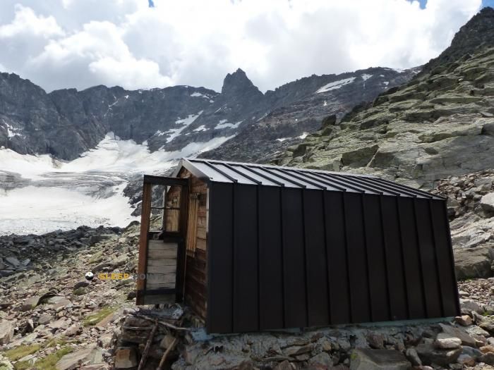
Strategically located in bivacco antoldi - malvezzi, senza tracce, su ghiacciaio, ronco canavese, turín, piamonte, italia, the Bivouac Antoldi-Malvezzy refuge makes exploring the area easier. At 2920 meters above sea level, this point of interest (45.53, 7.377) is a vital resource when planning your route.

See more
See more
Usuario

Lucas Martinez

Premium user

Live weather: Bivouac Antoldi-Malvezzy

The current weather in Bivouac Antoldi-Malvezzy indicates a temperature of 5.1°C, although the 5.2 km/h wind makes it feel like 1.4°C. Watch out for gusts of 30.2 km/h. The snow altitude (freezing level 0°) is around 4010 m and today we will reach a high of 5.1°C.
Temperature

5.1°C

Feels like: 1.4°C
Wind

5.2 km/h

Gusts: 30.2 km/h
Freezing level 0°

4010 m

Snow line
Sky & UV

UV 0

Clouds: 100%

Next 48 hours evolution

7-day forecast

04/06
5.1°
15.1 mm 30 km/h UV máx: 4.5
05:43 21:14
05/06
4.4° -0.8°
0.2 mm 30.4 km/h UV máx: 7.4
05:43 21:14
06/06
8.9° 2.6°
0.3 mm 10.8 km/h UV máx: 4.5
05:42 21:15
07/06
10.3° 3.5°
0.3 mm 11.7 km/h UV máx: 7.7
05:42 21:16
08/06
11° 5.5°
7.05 mm 12.3 km/h UV máx: 6.9
05:42 21:17
09/06
10.2° 2.7°
0 mm 17.4 km/h UV máx: 7.25
05:41 21:17
10/06
9.1° 0.3°
0 mm 13.8 km/h UV máx: 5.85
05:41 21:18

In this part of the Great Paradise , Bivouac Antoldi-Malvezzy It appears in a clearly alpine and not immediate sector, within the scope of Ronco Canavese, in the Piedmont, at 2920 meters altitude. The cartographic reference itself places it on the ground without trace and on glacier, a data that completely changes the reading of access: it is not just a question of gaining height, but of moving in an environment where orientation, the state of snow or ice and weather can make the day very difficult. In this context, its role fits well as support for high mountain routes and as a point of passage or link for long routes of the area, especially in relation to the Alta Via n. 2 della Valle d'Aosta which runs relatively close in its stages 9 and 10, and with the Alta Via Canavesana . More than a fast-approaching shelter, it works as a reference for cordals and traverses where it is appropriate to share effort and provide for logistics.

The altitude and the terrain around it make you think of a demanding approach, reserved for mountaineers with experience in high mountain environment. It is also necessary to keep in mind the autonomy: the registered sources are several kilometres away, so it is not wise to have water close to the vivac without having checked it before. From this position, the immediate environment is dominated by massif entity summits, with the Torre del Gran San Pietro and Punta d'Ondezana a short distance in a straight line, in addition to elevations such as Roccia Viva , Becco di Valsoera or Becca di Gay which reinforce the character of severe and high ground. This concentration of three thousand helps to understand the meaning of the Bivouac Antoldi-Malvezzy as an advanced basis for moving through a border sector between itinerary, ascension and crossing, where the management of the effort depends on both the level and exposure to time and the real conditions of the glacier.

Hiking routes from the refuge

AV2

Alta Via n. 2 della Valle d'Aosta - Tappa 10

↔ 14.000 km
AVC

Alta Via Canavesana

↔ Variable distance
22E

Sentiero 22E Bivacco Martinotti

↔ Variable distance
13CL

Itinerario 13 Cascate di Lillaz

↔ Variable distance
AV2

Alta Via n. 2 della Valle d'Aosta - Tappa 9

↔ 8.220 km
Local

Schiaroglio-Moncimur

↔ 11.1 km
17A

Sentiero Natura

↔ Variable distance

Nearby peaks

Becca di Gay

3621 m
Lat: 45.5142 Lon: 7.3207

Roccia Viva

3650 m
Lat: 45.5192 Lon: 7.3295

Torre del Gran San Pietro

3692 m
Lat: 45.5255 Lon: 7.3584

Punta d'Ondezana

3492 m
Lat: 45.5178 Lon: 7.3702

Becco di Valsoera

3369 m
Lat: 45.5112 Lon: 7.3756

Punta delle Sengie

3408 m
Lat: 45.5319 Lon: 7.3962

Punta Cissetta

3419 m
Lat: 45.5476 Lon: 7.3593

Punta Fenilia

3053 m
Lat: 45.5742 Lon: 7.3593

Nearby water fountains

Fuente

3.56 Km
Lat: 45.5742 Lon: 7.3593

Fuente

3.8 Km
Lat: 45.5742 Lon: 7.3593

Fuente

6.53 Km
Lat: 45.5742 Lon: 7.3593

Fuente

6.93 Km
Lat: 45.5742 Lon: 7.3593

Fuente

6.98 Km
Lat: 45.5742 Lon: 7.3593

Fuente

6.98 Km
Lat: 45.5742 Lon: 7.3593

Fuente

7.07 Km
Lat: 45.5742 Lon: 7.3593

Fuente

7.25 Km
Lat: 45.5742 Lon: 7.3593
FAQ

Frequently asked questions

Pregunta frecuente
Are there other mountain refuges near Bivouac Antoldi-Malvezzy?
Yes, nearby you can find other options to spend the night or take shelter. El refugio más próximo es el Bivouac Gino Carpano, que se encuentra a aproximadamente 2.9 km de distancia.
Pregunta frecuente
At what exact altitude is the Bivouac Antoldi-Malvezzy refuge located?
The Bivouac Antoldi-Malvezzy refuge is located at an altitude of 2920 meters above sea level, in the natural surroundings of bivacco antoldi - malvezzi, senza tracce, su ghiacciaio, ronco canavese, turín, piamonte, italia.
Pregunta frecuente
What are the GPS coordinates of the Bivouac Antoldi-Malvezzy refuge?
To locate the Bivouac Antoldi-Malvezzy refuge on your GPS or map, use the following coordinates: Latitude 45.53 and Longitude 7.377.
More areas

Other areas

Collaborative

Together we improve

image

Send your photos

You can upload photos of shelters and update their status so other users know if they can go there.

Get started
Get started
image

Rate the shelter

Leave your comments to rate the shelter’s condition. In the mountains, we look after each other.

Get started
Get started
image

Add new ones

Did we miss any? Publish the shelters you know so everyone can use them.

Get started
Get started
Download for free from the Apple App Store and Play Store.

Download the app and start looking for the shelter of your next adventure

Aplicación móvil para encontrar refugios de montaña donde dormir
Aplicación móvil para encontrar refugios de montaña donde dormir.
Mapa interactivo de refugios de montaña en los Pirineos dentro de la app
Mapa de refugios de montaña para senderismo y trekking en la app.
Pantalla con información de refugio de montaña con altitud capacidad y servicios
Pantalla con información de refugio de montaña con altitud capacidad y servicios.
Detalles de refugio de montaña con servicios y meteorología en aplicación móvil
Detalles de refugio de montaña con servicios y meteorología en aplicación móvil.
Aplicación para explorar refugios de montaña mediante mapa interactivo
Aplicación para explorar refugios de montaña mediante mapa interactivo.
Ficha completa de refugio de montaña con opiniones y servicios
Ficha completa de refugio de montaña con opiniones y servicios.
Información detallada de refugio en app para montañeros
Información detallada de refugio en app para montañeros.
Listado de refugios de montaña para senderismo y trekking
Listado de refugios de montaña para senderismo y trekking.
Explorar refugios de montaña desde una aplicación móvil
Explorar refugios de montaña desde una aplicación móvil.