Mountain refuge Bergerie de Jasneuf

We have it listed in the app!


            Mountain refuge Bergerie de Jasneuf in bergerie jas de jasneuf, sentier des rochers du parquet, chichilianne, grenoble, isère, auvergne-rhône-alpes, francia metropolitana, 38930, francia
Five orange stars in a horizontal row representing a five-star rating.

Bergerie de Jasneuf

Lat: 44.801xxx – Lon: 5.495xxx
📍 bergerie jas de jasneuf, sentier des rochers du parquet, chichilianne, grenoble, isère, auvergne-rhône-alpes, francia metropolitana, 38930, francia
Bergerie de Jasneuf

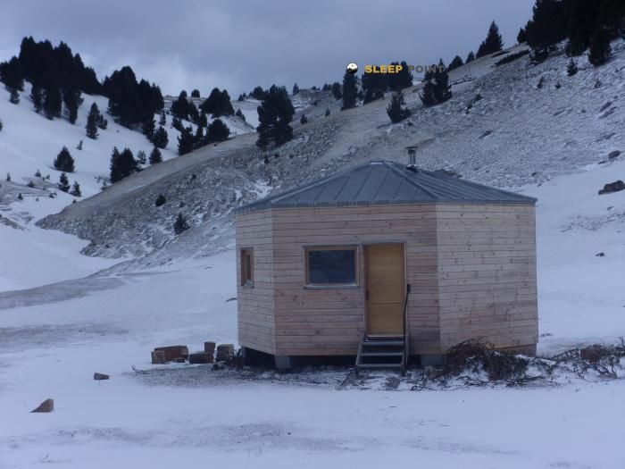
The mountains of bergerie jas de jasneuf, sentier des rochers du parquet, chichilianne, grenoble, isère, auvergne-rhône-alpes, francia metropolitana, 38930, francia hide essential places like the Bergerie de Jasneuf refuge. Situated at an elevation of 1627 meters, it offers protection and rest. Its exact coordinates are 44.801, 5.495.

See more
See more
Usuario

Lucas Martinez

Premium user

Live weather: Bergerie de Jasneuf

At the moment, conditions in Bergerie de Jasneuf (1627m) show 7.5°C (feels like 5°C). Wind is blowing at 6.8 km/h with gusts up to 16.2 km/h. Today, a high of 12.4°C is expected and the freezing level is at 4160 meters.
Temperature

7.5°C

Feels like: 5°C
Wind

6.8 km/h

Gusts: 16.2 km/h
Freezing level 0°

4160 m

Snow line
Sky & UV

UV 0

Clouds: 100%

Next 48 hours evolution

7-day forecast

04/06
12.4° 5.5°
33.7 mm 22.1 km/h UV máx: 4.65
05:53 21:18
05/06
9.9° 4.3°
0 mm 22 km/h UV máx: 6
05:53 21:19
06/06
16.8° 7.1°
0 mm 13.8 km/h UV máx: 7.75
05:53 21:20
07/06
17.8° 9.1°
0 mm 7.8 km/h UV máx: 7.35
05:52 21:21
08/06
19.5° 11.5°
0 mm 17.1 km/h UV máx: 6.7
05:52 21:21
09/06
12.5° 8.3°
0.6 mm 15.6 km/h UV máx: 5.4
05:52 21:22
10/06
17.4° 6.5°
0 mm 12.3 km/h UV máx: 7.5
05:51 21:23

Map reading in the Vercors

The clear thing when planning the Bergerie de Jasneuf is its territorial role: it appears in the sector of Chichilianne, on the senier des rochers du parquet and within the massif of the Vercors 1627 meters. This combination places it in a range of medium-high calcareous mountain where the shelter works less as an isolated destination and more as a useful reference between crossing routes. In this environment they link long-distance routes such as Traversée du Vercors by the GR 93, the GR 91 of the North-South crossing and the GTV or Tour du Vercors à pied, so that its location can serve to divide day, reorganize a stage or resolve a withdrawal if weather, tiredness or orientation force to shorten.

Step point and withdrawal margin

The near relief helps to understand that practical use. Towards the immediate environment there are elevations such as Tourte-Barreaux the Rochers de Plautret or Tête de la Graille , modest summits at absolute altitude but sufficient to fit steps, create highlights and demand careful reading of the ground. In the area of Chichilianne the reference of Mont Aiguille , great milestone of the eastern edge of the Vercors, which gives context to a landscape of limestone walls, balconies and trails where it is not right to be trusted even if the shelter is located near the map. This is precisely why it can be valuable as an escape point: not so much as a basis for concrete ascension, but as a support in a network of roads where an orderly withdrawal is worth more than forcing the itinerary.

Reasonable autonomy is needed. The invented sources are several kilometres away, none particularly close, so it is not wise to take immediate water for granted in the shelter environment. Nor should we assume services or equipment beyond their existence as a mountain coat. For those who travel this sector of the Vercors, the key is to use it as a reference of navigation and safety: to place well their position with respect to the rochers du parquet, to contrast mapping and to anticipate alternatives before entering a long stage or exposed to the change of time.

Hiking routes from the refuge

GTV

Tour du Vercors à pied

↔ 324 km
GR 93

Traversée du Vercors

↔ Variable distance
Local

Les carnets d'Achiane

↔ Variable distance
Local

Pas de l'Aiguille

↔ Variable distance
GR 95

De Saillans à Lus-la-Croix-Haute

↔ Variable distance
GR 91

Traversée du Vercors Nord-Sud - Classique

↔ Variable distance

Nearby peaks

Roc Mazilier

1949.73 m
Lat: 44.8438 Lon: 5.5101

Tourte-Barreaux

1876 m
Lat: 44.8188 Lon: 5.4942

Tête de la Graille

1885 m
Lat: 44.8359 Lon: 5.4985

Tête du Petit Jardin

1799 m
Lat: 44.7637 Lon: 5.4926

Rochers de Plautret

1827 m
Lat: 44.8004 Lon: 5.4584

Sommet du Tisserand

1951 m
Lat: 44.7763 Lon: 5.535

Tête des Baumiens

Altitude not available
Lat: 44.8011 Lon: 5.5173

Tête des Chanaux

1888.6 m
Lat: 44.794 Lon: 5.5171

Nearby water fountains

Fuente

4.76 Km
Lat: 44.794 Lon: 5.5171

Fuente

4.96 Km
Lat: 44.794 Lon: 5.5171

Fontaine du Pas des Bachassons

5.31 Km
Lat: 44.794 Lon: 5.5171

Fuente

6.14 Km
Lat: 44.794 Lon: 5.5171

Fuente

6.18 Km
Lat: 44.794 Lon: 5.5171

Fuente

6.19 Km
Lat: 44.794 Lon: 5.5171

Fuente

6.22 Km
Lat: 44.794 Lon: 5.5171

Fuente

6.24 Km
Lat: 44.794 Lon: 5.5171
FAQ

Frequently asked questions

Pregunta frecuente
Are there other mountain refuges near Bergerie de Jasneuf?
Yes, nearby you can find other options to spend the night or take shelter. El refugio más próximo es el Cabane PNRV des Chaumailloux, que se encuentra a aproximadamente 1.4 km de distancia.
Pregunta frecuente
At what exact altitude is the Bergerie de Jasneuf refuge located?
The Bergerie de Jasneuf refuge is located at an altitude of 1627 meters above sea level, in the natural surroundings of bergerie jas de jasneuf, sentier des rochers du parquet, chichilianne, grenoble, isère, auvergne-rhône-alpes, francia metropolitana, 38930, francia.
Pregunta frecuente
What are the GPS coordinates of the Bergerie de Jasneuf refuge?
To locate the Bergerie de Jasneuf refuge on your GPS or map, use the following coordinates: Latitude 44.801 and Longitude 5.495.
More areas

Other areas

Collaborative

Together we improve

image

Send your photos

You can upload photos of shelters and update their status so other users know if they can go there.

Get started
Get started
image

Rate the shelter

Leave your comments to rate the shelter’s condition. In the mountains, we look after each other.

Get started
Get started
image

Add new ones

Did we miss any? Publish the shelters you know so everyone can use them.

Get started
Get started
Download for free from the Apple App Store and Play Store.

Download the app and start looking for the shelter of your next adventure

Aplicación móvil para encontrar refugios de montaña donde dormir
Aplicación móvil para encontrar refugios de montaña donde dormir.
Mapa interactivo de refugios de montaña en los Pirineos dentro de la app
Mapa de refugios de montaña para senderismo y trekking en la app.
Pantalla con información de refugio de montaña con altitud capacidad y servicios
Pantalla con información de refugio de montaña con altitud capacidad y servicios.
Detalles de refugio de montaña con servicios y meteorología en aplicación móvil
Detalles de refugio de montaña con servicios y meteorología en aplicación móvil.
Aplicación para explorar refugios de montaña mediante mapa interactivo
Aplicación para explorar refugios de montaña mediante mapa interactivo.
Ficha completa de refugio de montaña con opiniones y servicios
Ficha completa de refugio de montaña con opiniones y servicios.
Información detallada de refugio en app para montañeros
Información detallada de refugio en app para montañeros.
Listado de refugios de montaña para senderismo y trekking
Listado de refugios de montaña para senderismo y trekking.
Explorar refugios de montaña desde una aplicación móvil
Explorar refugios de montaña desde una aplicación móvil.