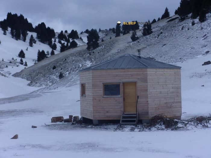
Mountain refuge Baraque du Pison
We have it listed in the app!
We have it listed in the app!


Protected by the wild surroundings of gîte onf du pison, liaison du col di pison à la fontaine des bachassons, chichilianne, grenoble, isère, auvergne-rhône-alpes, francia metropolitana, 38930, francia, the Baraque du Pison refuge is your best ally at 1540 meters of elevation. Once you reach its coordinates (44.81, 5.473), you can enjoy a well-deserved mountain rest.
8.7°C
Feels like: 5.6°C10.9 km/h
Gusts: 26.6 km/h4160 m
Snow lineUV 0
Clouds: 90% 34.6 mm
 25.7 km/h
 UV máx: 4.65
 05:53
05:53
 21:19
0.1 mm
21 km/h
UV máx: 6
05:53
21:19
0 mm
13.8 km/h
UV máx: 7.75
05:53
21:20
0 mm
7.8 km/h
UV máx: 7.35
05:52
21:21
0 mm
17.1 km/h
UV máx: 6.7
05:52
21:21
0.6 mm
15.6 km/h
UV máx: 5.4
05:52
21:22
0 mm
12.3 km/h
UV máx: 7.5
05:51
21:23
21:19
0.1 mm
21 km/h
UV máx: 6
05:53
21:19
0 mm
13.8 km/h
UV máx: 7.75
05:53
21:20
0 mm
7.8 km/h
UV máx: 7.35
05:52
21:21
0 mm
17.1 km/h
UV máx: 6.7
05:52
21:21
0.6 mm
15.6 km/h
UV máx: 5.4
05:52
21:22
0 mm
12.3 km/h
UV máx: 7.5
05:51
21:23
In the field of Chichilianne on the eastern edge of the Vercors , this cabin is inserted into a landscape of limestone relief, wooded slopes and highlights that announce the proximity of itineraries and classic steps of the area. The most recognizable geographical reference is the environment of Monte Aiguille , the emblematic mountain of the Trièves and the eastern front of the Vercors, which helps to understand the character of the land: medium and high calcareous mountain, with rapid changes of exposure and routes where orientation and meteorology weigh more than the simple distance.
Baraque du Pison at 1540 metres, it fits well as a support point on continuity routes rather than as an isolated destination. Its position is consistent with the logic of the Traversée du Vercors for GR 93 , of GR 91 on the great North-South journey and the itinerary of Tour du Vercors à pied (GTV). It may also have an interest as a place of retreat or reorganisation of the day in a sector where several routes cross and where a change of time may force a shorten stage, a step to be taken or a two-day split.
In the immediate environment there are elevations such as Rochers de Plautret , just over 1.5 km, and Tourte-Barreaux , already about 1900 meters. They are beyond Tête de la Graille and Roc Mazilier , summits that strengthen the mountain profile of the sector and explain the interest of the shelter as a sober basis for moving through cords and secondary reliefs of the southern Vercors. It is not appropriate to interpret it as automatic access to simple ascent: the field of lapiaz, forest and limestone bars may require fine reading of the itinerary.
From a logistical point of view, the nearest water data is not immediate: Fontaine du Pas des Bachassons It's more than 5 km away. This is why it is necessary to raise the day with sufficient autonomy and without giving up the supply in the vicinity. In a cross-border area like this, the shelter mainly serves a guard function within a network of long itineraries, useful for linking valleys and steps of the Vercors with a prudent approach of timetables, water and mountain conditions.


📏 1.4 Km
⛰️ 1030 m

📏 2 Km
⛰️ 1627 m

📏 2.1 Km
⛰️ 1600 m

📏 2.5 Km
⛰️ 1419 m

📏 3.1 Km
⛰️ 1645 m
📏 3.1 Km
⛰️ 1665 m

📏 3.1 Km
⛰️ 1530 m

📏 3.6 Km
⛰️ 1692 m
Download the app and start looking for the shelter of your next adventure


Find a place to sleep before night falls.


