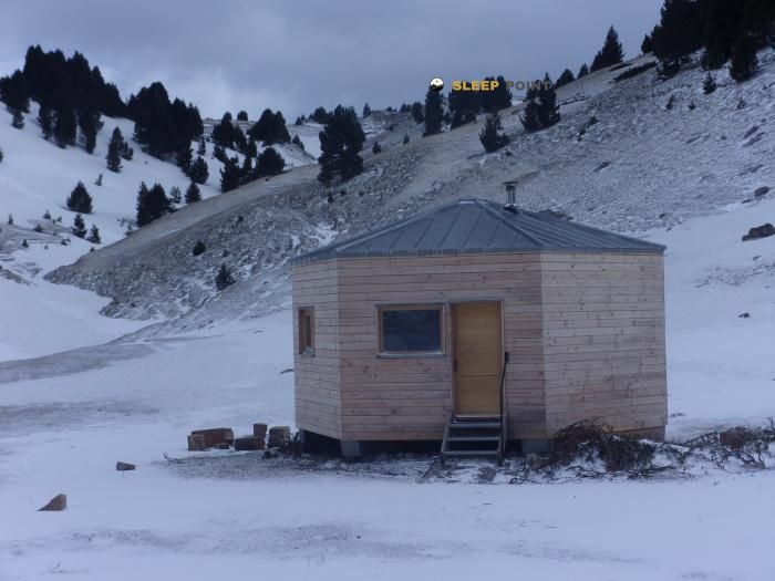
Mountain refuge Grange de St Roman
We have it listed in the app!
We have it listed in the app!


Prepare your backpack and head to grange de saint-roman, liaison du col di pison à la fontaine des bachassons, chichilianne, grenoble, isère, auvergne-rhône-alpes, francia metropolitana, 38930, francia. There you will find the Grange de St Roman refuge at 1692 meters of elevation. An essential stop along the way (Lat: 44.777, Lon: 5.47) for any mountain enthusiast.
8°C
Feels like: 5°C8.2 km/h
Gusts: 27 km/h4190 m
Snow lineUV 0
Clouds: 65% 31.2 mm
 18.8 km/h
 UV máx: 4.65
 05:53
05:53
 21:18
0 mm
21.8 km/h
UV máx: 6
05:53
21:19
0 mm
13.8 km/h
UV máx: 7.75
05:53
21:20
0 mm
7.8 km/h
UV máx: 7.35
05:52
21:21
0 mm
17.1 km/h
UV máx: 6.7
05:52
21:21
0.3 mm
15 km/h
UV máx: 5.4
05:52
21:22
0 mm
9.5 km/h
UV máx: 7.5
05:52
21:23
21:18
0 mm
21.8 km/h
UV máx: 6
05:53
21:19
0 mm
13.8 km/h
UV máx: 7.75
05:53
21:20
0 mm
7.8 km/h
UV máx: 7.35
05:52
21:21
0 mm
17.1 km/h
UV máx: 6.7
05:52
21:21
0.3 mm
15 km/h
UV máx: 5.4
05:52
21:22
0 mm
9.5 km/h
UV máx: 7.5
05:52
21:23
The land is in charge here. around Grange of St Roman At 1692 meters, the landscape is organized between lomas, highlights and small elevations that mark well the orientation on the ground, in the surroundings of Chichilianne, within Auvergne-Rhône@-@ Alpes. It does not appear as a shelter associated with a large network of itineraries identified in the available data, so it should be put forward with a conservative logic: more as a point support in mountain than as a destination to which to rely all the logistics of the day.
The geographical reference helps to place it. The mention of the liaison du col di pison à la fontaine des bachassons places it in a strip where the steps and links between sides can weigh more than the simple distance. In this type of terrain, the effort does not depend only on the accumulated gap: they also influence the continuity of the path, the exposure to the wind and the ease of reading hills, shoulders and direction changes when visibility gets worse.
Its practical role fits mainly as a support point for moving around this mountain sector and for a long day, rather than as a basis for specific routes documented here. The nearby tops, such as Tête du Petit Jardin or Le Dôme they reinforce this chained relief and exits in which the local orientation matters. They also help to understand that, even if the altitude is not extreme, the environment can be serious if time is complicated.
Water management deserves attention. The registered sources are far from the shelter, with the nearest one to more than 4 kilometres, and therefore no immediate supply should be available in the vicinity. For hiking or hiking around the area, it is reasonable to leave with sufficient autonomy and to check before the exit both the access and the actual situation of the water point to be used.
Overall, this coat fits better into sober and well-prepared plans: pre-reading of the map, margin for time changes and realistic expectations about what you can solve on the road. In a sector where the value of the shelter depends a lot on how it comes in and to which side or cordal it is intended to continue, this prudence weighs more than any improvised approach.


Download the app and start looking for the shelter of your next adventure


Find a place to sleep before night falls.