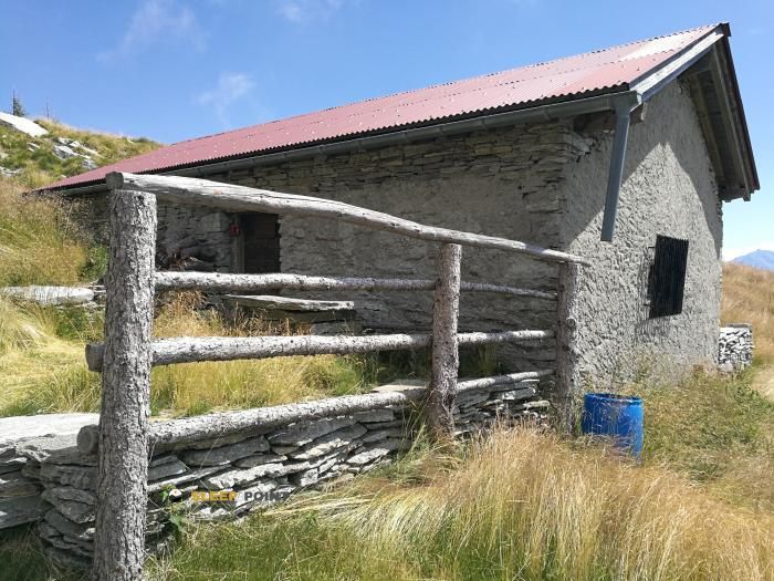
Mountain refuge Rifugio Peurett
We have it listed in the app!
We have it listed in the app!


Located in the heart of rifugio alpe di peurett, alpe di pèu - lago di canèe, riviera, circolo della riviera, distretto di riviera, tesino, 6705, suiza, the Rifugio Peurett refuge offers shelter at 1746 meters above sea level. Ideal for trekking and nature lovers, this mountain shelter (Lat: 46.291, Lon: 9.035) is the perfect starting point or resting place for local routes.
7.8°C
Feels like: 5.4°C2.2 km/h
Gusts: 2.2 km/h3710 m
Snow lineUV 0
Clouds: 100% 25.3 mm
 13.1 km/h
 UV máx: 5.7
 05:33
05:33
 21:10
19.52 mm
15.5 km/h
UV máx: 7.4
05:33
21:11
4.4 mm
6.6 km/h
UV máx: 6.2
05:32
21:12
0.3 mm
9.8 km/h
UV máx: 5.85
05:32
21:12
2.1 mm
10.6 km/h
UV máx: 7.25
05:32
21:13
13.2 mm
12.6 km/h
UV máx: 5.65
05:31
21:14
0 mm
12.9 km/h
UV máx: 3.85
05:31
21:14
21:10
19.52 mm
15.5 km/h
UV máx: 7.4
05:33
21:11
4.4 mm
6.6 km/h
UV máx: 6.2
05:32
21:12
0.3 mm
9.8 km/h
UV máx: 5.85
05:32
21:12
2.1 mm
10.6 km/h
UV máx: 7.25
05:32
21:13
13.2 mm
12.6 km/h
UV máx: 5.65
05:31
21:14
0 mm
12.9 km/h
UV máx: 3.85
05:31
21:14
At 1746 meters, Rifugio Peurett It is located in a mountain strip where the forest leaves way to a more open terrain and hillsides that link with clearly alpine heights. Its position in the Riviera del Tesino places it in a transition environment between the valley bottom and the summits that close the sector, with close references as Torrone Rosso , Piz de Molinera or Mot Ciarin which help to understand the mountainous character of the area without turning the shelter into a simple local point of passage.
It also fits within a broader context of journey. In this sector there are long-range itineraries such as E1 , in addition to the Sentiero Riviera, while more powerful Swiss routes go further. This suggests a practical utility for those who walk through the Tesino and need to divide days or gain height before entering higher ground, not just for short excursions from the valley.
The relationship with the access valley is important: the shelter is in a remote area with regard to cores like Riviera and within a relief where the orientation and continuity of the itinerary count more than the closeness in a straight line. There is no data here to deduct services or interior equipment, so it should be raised with sufficient autonomy and with margin in the face of time changes, something usual in medium-high levels of the Tessa mountain.
As for water, there is a relatively close source, about 550 meters away, and another one a little more than 1 km away. However, in the mountain, the actual availability may vary according to time and conditions, so it is still wise to confirm the point of supply before leaving and not to depend on finding water without having anticipated it.


📏 3.9 Km
⛰️ 1910 m

📏 4.4 Km
⛰️ 1575 m

📏 5 Km
⛰️ 1890 m

📏 6.4 Km
⛰️ 1570 m
📏 6.7 Km
⛰️ 1773 m

📏 6.7 Km
⛰️ 1594 m

📏 7 Km
⛰️ 1638 m

📏 7.4 Km
⛰️ 2066 m
Download the app and start looking for the shelter of your next adventure


Find a place to sleep before night falls.


