Mountain refuge Alva

We have it listed in the app!


            Mountain refuge Alva in capanna alpe d'alva, cà da löügh, verscio, lègri, lodrino, riviera, circolo della riviera, distretto di riviera, tesino, 6527, suiza
Five orange stars in a horizontal row representing a five-star rating.

Alva

Lat: 46.3xxx – Lon: 8.953xxx
📍 capanna alpe d'alva, cà da löügh, verscio, lègri, lodrino, riviera, circolo della riviera, distretto di riviera, tesino, 6527, suiza
Alva

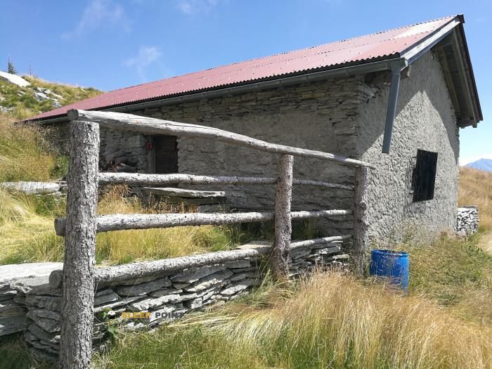
The Alva refuge stands at 1570 meters above sea level, overlooking the surroundings of capanna alpe d'alva, cà da löügh, verscio, lègri, lodrino, riviera, circolo della riviera, distretto di riviera, tesino, 6527, suiza. It is a key spot for mountaineers looking to spend the night or take a break. Its coordinates (46.3, 8.953) place it in a strategic position for exploring the peaks and trails of the region.

See more
See more
Usuario

Lucas Martinez

Premium user

Live weather: Alva

If you plan to go up today to 1570 m at Alva, you will find 10.5°C with a feels-like temperature of 9.6°C. The freezing level is at 3780 m. The forecast shows steady winds of 0.7 km/h and peaks of 23.8 km/h. A high of 13.1°C is expected.
Temperature

10.5°C

Feels like: 9.6°C
Wind

0.7 km/h

Gusts: 23.8 km/h
Freezing level 0°

3780 m

Snow line
Sky & UV

UV 2.05

Clouds: 100%

Next 48 hours evolution

7-day forecast

04/06
13.1° 8.3°
34.5 mm 11.7 km/h UV máx: 5.9
05:34 21:11
05/06
14.5° 6.3°
20.1 mm 15.8 km/h UV máx: 7.1
05:33 21:11
06/06
14° 9.4°
14.38 mm 5.9 km/h UV máx: 7
05:33 21:12
07/06
18.5° 10.1°
0 mm 6.6 km/h UV máx: 6.85
05:32 21:13
08/06
18.9° 12.1°
1.2 mm 9 km/h UV máx: 7.3
05:32 21:14
09/06
15.9° 11.3°
11.25 mm 10.1 km/h UV máx: 6.15
05:32 21:14
10/06
16.3° 10.8°
0 mm 11.4 km/h UV máx: 5.4
05:32 21:15

You should read the map well before you have this free shelter. Alva in the area of Riviera of the canton of Tesino, it is located 1.570 meters on a mountain slope that links the bottom of the valley with higher heights and increasingly open terrain. In this part of the Tesino, between cores such as Lodrino, Osogna or Iragna, the orientation of the itinerary matters as much as the physical form: it is not an urban passage shelter or an installation linked to immediate accesses, but a mountain support within a broken relief.

His interest appears above all by fitting him into long tours or on liaison days. The area is marked by traces known as the High Strada , the Strada Bassa or the E1 European itinerary, in addition to the Trans Swiss Trail, so that the shelter can serve as an intermediate reference to divide stages or to leave the valley to medium heights. It also remains under the same lines as Poncione Rosso or Cima Lunga, which reinforces its role as a support point in mountain terrain, but without automatically making it a comfortable basis for ascension if the day has not been prepared well.

In practical planning, the most useful data is water. There are relatively close sources, with one of them at about 1.84 km and another less than 2 km, but that distance already means that it does not take for granted an immediate supply next to the shelter. In a free shelter of this kind, it is appropriate to reach with sufficient autonomy and to consider the actual availability of water as a matter to be verified on the ground and according to the time.

For this reason, rather than to put it as an isolated destination, Alva works better as a reference within a careful navigation: clear location on mapping, time change margin and own resources forecast. In the Tesino, where the itineraries can combine forest, slope path and sections more exposed to the mountain environment, this prudence weighs more than any expectation of comfort.

Hiking routes from the refuge

E1

European Long distance path E1 - part Switzerland

↔ Variable distance
2

Trans Swiss Trail

↔ 18 km
Local

Strada Alta

↔ Variable distance
Local

Pellegio-Ponte di Biasca

↔ Variable distance
Local

Ponte di Biasca-Personico

↔ Variable distance
Local

Strada Bassa

↔ Variable distance
Local

Biasca FFS - Prealberto

↔ Variable distance
Local

Sentiero Riviera

↔ Variable distance

Nearby peaks

Cima Lunga

2488 m
Lat: 46.3075 Lon: 8.899

Poncione del Vènn

2477 m
Lat: 46.2743 Lon: 8.9071

Cima di Bri

2520 m
Lat: 46.305 Lon: 8.8842

Pizzo Ricuca

2282 m
Lat: 46.3297 Lon: 8.9198

Poncione Rosso

2505 m
Lat: 46.2993 Lon: 8.9116

Cima Cioltro

1847 m
Lat: 46.3097 Lon: 9.0154

Cima di Visghéd

1924 m
Lat: 46.2746 Lon: 8.9605

Filo delle Lettere

2115 m
Lat: 46.256 Lon: 8.9355

Nearby water fountains

Fuente

1.84 Km
Lat: 46.256 Lon: 8.9355

Fuente

1.98 Km
Lat: 46.256 Lon: 8.9355

Fuente

2.16 Km
Lat: 46.256 Lon: 8.9355

Fuente

2.18 Km
Lat: 46.256 Lon: 8.9355

Fuente

2.39 Km
Lat: 46.256 Lon: 8.9355

Fuente

2.95 Km
Lat: 46.256 Lon: 8.9355

Fuente

3.09 Km
Lat: 46.256 Lon: 8.9355

Fuente

3.86 Km
Lat: 46.256 Lon: 8.9355
FAQ

Frequently asked questions

Pregunta frecuente
At what exact altitude is the Alva refuge located?
The Alva refuge is located at an altitude of 1570 meters above sea level, in the natural surroundings of capanna alpe d'alva, cà da löügh, verscio, lègri, lodrino, riviera, circolo della riviera, distretto di riviera, tesino, 6527, suiza.
Pregunta frecuente
What are the GPS coordinates of the Alva refuge?
To locate the Alva refuge on your GPS or map, use the following coordinates: Latitude 46.3 and Longitude 8.953.
Pregunta frecuente
Is it necessary to carry a GPS to reach the Alva refuge?
It is always highly recommended to carry a GPS device, a route track, or a topographic map in the mountains. You can use the coordinates 46.3, 8.953 to locate this refuge precisely.
More areas

Other areas

Collaborative

Together we improve

image

Send your photos

You can upload photos of shelters and update their status so other users know if they can go there.

Get started
Get started
image

Rate the shelter

Leave your comments to rate the shelter’s condition. In the mountains, we look after each other.

Get started
Get started
image

Add new ones

Did we miss any? Publish the shelters you know so everyone can use them.

Get started
Get started
Download for free from the Apple App Store and Play Store.

Download the app and start looking for the shelter of your next adventure

Aplicación móvil para encontrar refugios de montaña donde dormir
Aplicación móvil para encontrar refugios de montaña donde dormir.
Mapa interactivo de refugios de montaña en los Pirineos dentro de la app
Mapa de refugios de montaña para senderismo y trekking en la app.
Pantalla con información de refugio de montaña con altitud capacidad y servicios
Pantalla con información de refugio de montaña con altitud capacidad y servicios.
Detalles de refugio de montaña con servicios y meteorología en aplicación móvil
Detalles de refugio de montaña con servicios y meteorología en aplicación móvil.
Aplicación para explorar refugios de montaña mediante mapa interactivo
Aplicación para explorar refugios de montaña mediante mapa interactivo.
Ficha completa de refugio de montaña con opiniones y servicios
Ficha completa de refugio de montaña con opiniones y servicios.
Información detallada de refugio en app para montañeros
Información detallada de refugio en app para montañeros.
Listado de refugios de montaña para senderismo y trekking
Listado de refugios de montaña para senderismo y trekking.
Explorar refugios de montaña desde una aplicación móvil
Explorar refugios de montaña desde una aplicación móvil.