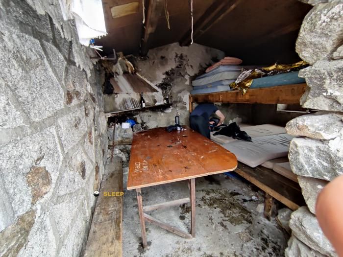
Mountain refuge Refuge d'En Beys
We have it listed in the app!
We have it listed in the app!


Conquering the trails of refuge d'en beys, tartera, formiguères, prades, pirineos orientales, occitania, francia metropolitana, 66210, francia is easier with the Refuge d'En Beys refuge. Located at 1980 m (coordinates 42.627, 1.944), it is the ideal shelter against harsh mountain weather.
7.9°C
Feels like: 5.5°C4 km/h
Gusts: 12.2 km/h4440 m
Snow lineUV 0
Clouds: 100% 23.4 mm
 10.2 km/h
 UV máx: 5.15
 06:15
06:15
 21:25
2 mm
9.5 km/h
UV máx: 7.95
06:15
21:26
0.1 mm
11 km/h
UV máx: 6.75
06:15
21:26
0.7 mm
10.3 km/h
UV máx: 6.95
06:14
21:27
4.5 mm
10.1 km/h
UV máx: 7.65
06:14
21:28
3.6 mm
9.4 km/h
UV máx: 7.5
06:14
21:28
1.2 mm
7.7 km/h
UV máx: 7.85
06:14
21:29
21:25
2 mm
9.5 km/h
UV máx: 7.95
06:15
21:26
0.1 mm
11 km/h
UV máx: 6.75
06:15
21:26
0.7 mm
10.3 km/h
UV máx: 6.95
06:14
21:27
4.5 mm
10.1 km/h
UV máx: 7.65
06:14
21:28
3.6 mm
9.4 km/h
UV máx: 7.5
06:14
21:28
1.2 mm
7.7 km/h
UV máx: 7.85
06:14
21:29
Here the mountain feels exposed. At 1.980 meters, the Refuge d'En Beys remains in a high mountain sector of the eastern French Pyrenees, within Occitania and in the surroundings of Formiguères, in an area of ponds, stony lomas and cords where time can change quickly. This altitude does not make it an extreme shelter on its own, but it does mark a fresh, more windy and more demanding environment if you arrive with backpack or long days.
Their practical interest is closely linked to the management of the effort. It is not a point for improvising a short exit without more context, but a useful support for dividing routes, regulating a journey or having an intermediate reference on more continuous routes. In this sector, long-range strands such as GR 7 and HRP so that it can function both as a natural link between stages and as a withdrawal option if the weather is complicated or the pace of running does not allow to complete a more ambitious day. In open pyrenees, this possibility of shortening or reorganizing the route has real value.
The environment reinforces this mountain character. Close to it are the tops like the Pic d'Étang Faury , Pic Lanoux or Pic de Mortiers , reliefs that help understand the type of land: mineral earrings, hills, lacustrous areas and orientation that can become more delicate with fog, wind or storm. It also fits into routes such as access to the Étang d'En Beys or variants of the return of the Carlit ponds, although the final hardness will depend on the starting point and the chosen route.
It is appropriate to plan with autonomy. The registered sources are several kilometres away, so it is not wise to have immediate water in the vicinity without having checked it before. In such an area, more than the isolated distance matters the combination of level, terrain and exposure. This is why it is particularly useful for those who need to order the day, to reserve space for time changes and to move with criteria on mountain crossings of the sector between Ariège and the Eastern Pyrenees.


Download the app and start looking for the shelter of your next adventure


Find a place to sleep before night falls.