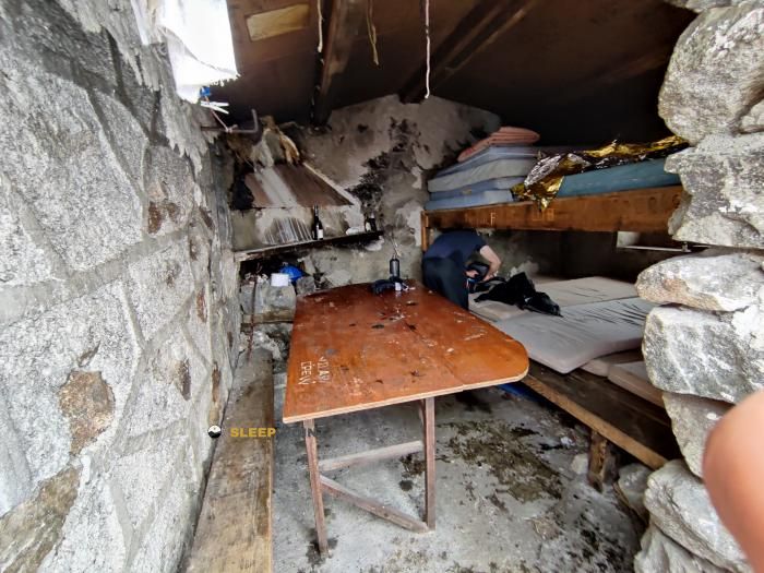
Mountain refuge Cabane Eychouzé
We have it listed in the app!
We have it listed in the app!


Discover the vastness of coume de menier, orlu, foix, ariège, occitania, francia metropolitana, 09110, francia by spending the night at the Cabane Eychouzé refuge. It sits at 2080 meters, offering a unique balcony over the natural landscape. Find it on the map at latitude 42.641 and longitude 1.92.
6.8°C
Feels like: 4.7°C6.3 km/h
Gusts: 18.4 km/h4220 m
Snow lineUV 1.4
Clouds: 100% 17.5 mm
 19.3 km/h
 UV máx: 5.1
 06:15
06:15
 21:25
1.6 mm
15 km/h
UV máx: 8.15
06:15
21:26
0.4 mm
7.4 km/h
UV máx: 7.15
06:15
21:26
0 mm
10.3 km/h
UV máx: 8
06:14
21:27
4.5 mm
8.6 km/h
UV máx: 8.25
06:14
21:28
3.6 mm
7.6 km/h
UV máx: 7.75
06:14
21:28
1.2 mm
7.7 km/h
UV máx: 7.9
06:14
21:29
21:25
1.6 mm
15 km/h
UV máx: 8.15
06:15
21:26
0.4 mm
7.4 km/h
UV máx: 7.15
06:15
21:26
0 mm
10.3 km/h
UV máx: 8
06:14
21:27
4.5 mm
8.6 km/h
UV máx: 8.25
06:14
21:28
3.6 mm
7.6 km/h
UV máx: 7.75
06:14
21:28
1.2 mm
7.7 km/h
UV máx: 7.9
06:14
21:29
In this high sector of Orlu , the mountain works more as a passing area than as an accessible valley background. The presence of GR 7 its variant 7B and the HRP the Cabane Echouzé at a useful point for those who travel long days along the eastern axis of the Ariège, near the transition to Andorra and the reliefs of the surroundings of En Beys and Lanoux. It is not a refuge associated with immediate access, but with a logic of cross, collation and continuity between sides.
At 2080 meters, the site fits into an open landscape of high mountain, with land where the orientation between cubes, lomas and steps becomes important as the forest is abandoned. Summits such as the Pic d'Étang Faury , Pic Lanoux or the Pic de l'Homme, which help to place the character of the sector: mineral relief, exposed environment and natural connections to cords and high ports. It also passes close the itinerary to L'Étang d'En Beys , which reinforces its role as a support for linking routes rather than as an isolated destination.
From a logistical point of view, it should be put forward as free shelter for mountaineers with autonomy. The registered sources are not next to the cabin: the nearest one is several kilometres away, so it is not necessary to have immediate water on arrival. In an area crossed by long-range routes, this detail weighs on planning as much as the meteorology or actual length of the stage. The Cabane Echouzé It thus fits into a very concrete use: to start or close a long day in height, with sufficient margin to manage water, orientation and time changes.


Download the app and start looking for the shelter of your next adventure


Find a place to sleep before night falls.