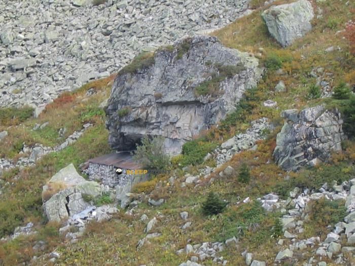
Mountain refuge Cabanon du lac de la Grande Léchère
We have it listed in the app!
We have it listed in the app!


Located at 1700 m above sea level, the Cabanon du lac de la Grande Léchère refuge is a true haven of peace in route des sappeys, sappey des cohendet, montgellafrey, saint-françois-longchamp, saint-jean-de-maurienne, saboya, auvergne-rhône-alpes, francia metropolitana, 73130, francia. Connect with nature and use its coordinates (45.407, 6.311) to guide your steps to its door.
7.9°C
Feels like: 5.5°C4.7 km/h
Gusts: 13 km/h4080 m
Snow lineUV 0
Clouds: 41% 22.2 mm
 17.6 km/h
 UV máx: 4.85
 05:48
05:48
 21:18
0.4 mm
14 km/h
UV máx: 6.25
05:47
21:18
0 mm
11.8 km/h
UV máx: 7.65
05:47
21:19
0.3 mm
10.2 km/h
UV máx: 7.4
05:47
21:20
1.5 mm
9.8 km/h
UV máx: 6.95
05:46
21:20
4.5 mm
10.9 km/h
UV máx: 4.15
05:46
21:21
0 mm
8.9 km/h
UV máx: 7.5
05:46
21:22
21:18
0.4 mm
14 km/h
UV máx: 6.25
05:47
21:18
0 mm
11.8 km/h
UV máx: 7.65
05:47
21:19
0.3 mm
10.2 km/h
UV máx: 7.4
05:47
21:20
1.5 mm
9.8 km/h
UV máx: 6.95
05:46
21:20
4.5 mm
10.9 km/h
UV máx: 4.15
05:46
21:21
0 mm
8.9 km/h
UV máx: 7.5
05:46
21:22
The approach to this coat moves on a ground of medium and high mountain where the relief forces to read the itinerary well and to measure the effort. About 1,700 metres, in the sector of Montgellafrey and Saint-François@-@ Longchamp, the environment of the lac de la Grande Léchère It combines open slopes, pastoral paths and sections where the orientation can change quickly as the lake's bucket is gained or bordered. It does not appear as a shelter designed for a casual arrival, but as a useful support within a mountain day in Savoy.
Their practical interest is less in the known services than in the position. Local routes such as the col du Chaussy and several trails of the area, so that it can fit into short journeys, liaison days or exits that seek to divide the gap. The nearby terrain also opens to tops as Le Grand Mas , Roche Bénite or Roc Rouge , which reinforces its role as a point of protection for mountaineers with a certain autonomy, rather than as a destination in itself. In this type of location, changes in the direction of the valley and the slopes influence the progression: the same route can alternate more exposed sections, humid areas and sectors where the path loses clarity.
For planning, it is important to focus on water and self-sufficiency. There is a very close source, a few meters away, in addition to other relatively close water points, but in mountain it is always interesting to confirm flow and conditions before having them as the only resource. Who uses this mountain shelter you should put it with margin against changes in time, visibility and state of the ground, especially if the idea is to link hills or move to higher levels. By location and context, it fits better with well-used mountain trails and mountaineers who prefer prudent planning rather than service-dependent logistics.


📏 0 Km
⛰️ 1680 m

📏 3.5 Km
⛰️ 2253 m

📏 4.6 Km
⛰️ 1390 m

📏 5.6 Km
⛰️ 2100 m

📏 5.8 Km
⛰️ 2050 m

📏 5.9 Km
⛰️ 1450 m

📏 6.2 Km
⛰️ 1500 m
📏 6.4 Km
⛰️ 1938 m
Download the app and start looking for the shelter of your next adventure


Find a place to sleep before night falls.


