Mountain refuge Sans nom
We have it listed in the app!
We have it listed in the app!


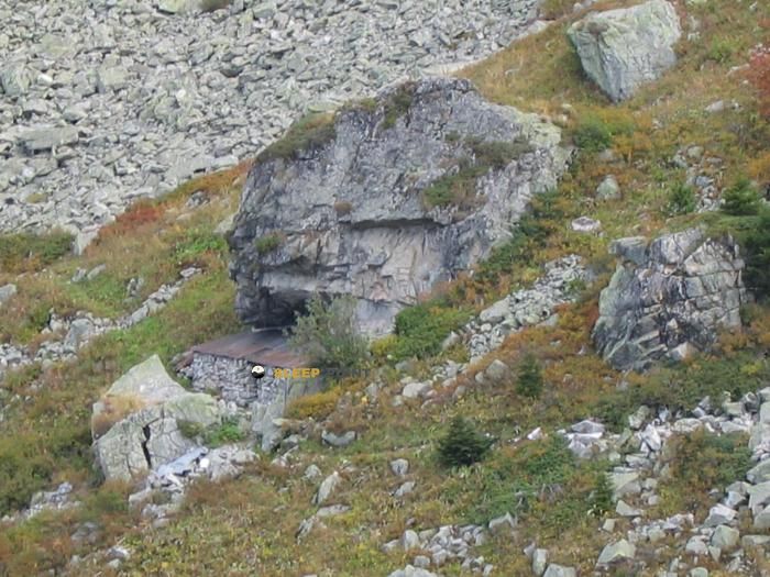
Located in the heart of chemin de la combe des planes, Épierre, saint-jean-de-maurienne, saboya, auvergne-rhône-alpes, francia metropolitana, 73220, francia, the Sans nom refuge offers shelter at 2100 meters above sea level. Ideal for trekking and nature lovers, this mountain shelter (Lat: 45.452, Lon: 6.343) is the perfect starting point or resting place for local routes.
6.8°C
Feels like: 3.5°C6.5 km/h
Gusts: 18 km/h4050 m
Snow lineUV 0
Clouds: 99% 24.1 mm
 16.6 km/h
 UV máx: 4.95
 05:47
05:47
 21:18
0.7 mm
11.4 km/h
UV máx: 6.25
05:47
21:18
0 mm
11.8 km/h
UV máx: 7.7
05:47
21:19
0.3 mm
10.2 km/h
UV máx: 7.65
05:46
21:20
1.35 mm
9.8 km/h
UV máx: 7.2
05:46
21:21
3 mm
11.7 km/h
UV máx: 1.25
05:46
21:21
0 mm
12.3 km/h
UV máx: 7.45
05:45
21:22
21:18
0.7 mm
11.4 km/h
UV máx: 6.25
05:47
21:18
0 mm
11.8 km/h
UV máx: 7.7
05:47
21:19
0.3 mm
10.2 km/h
UV máx: 7.65
05:46
21:20
1.35 mm
9.8 km/h
UV máx: 7.2
05:46
21:21
3 mm
11.7 km/h
UV máx: 1.25
05:46
21:21
0 mm
12.3 km/h
UV máx: 7.45
05:45
21:22
In the environment of the itinerary to Cheval Noir , this small mountain coat appears at 2100 meters as a useful reference on the Epierre side, inside the inner Savoy. The surrounding terrain links open slopes, mineral relief and nearby summits that help to read the position on the map well: very close are the Rocher de Sarvatan , Croix de la Couvre and, already with more alpine presence, the Grand Pic de la Lauzière . This closeness to several elevations marks the character of the place: not so much a destination in itself as a point of support in a mountain where the gap and orientation gain weight quickly.
Sans nom It may be useful when the day is extended, the weather changes, or it is appropriate to divide the effort into an increase in this high area over the valley of Maurienne. It also fits as an intermediate reference for those who move on local paths such as La Fuly, the Pastoral Chemin des Inversaires or the Bouchle de la Maison Blanche, always understanding that the real requirement will depend on the chosen route and the conditions of the land. In this type of location it is necessary to leave with sufficient autonomy, especially if it is proposed as a step coat and not as a stage end.
From the logistical point of view, the most relevant data is the presence of a fountain practically next to the shelter, something valuable in a level where wind, cold or a hot day can greatly increase the need for hydration. However, in the mountains it is not appropriate to rely entirely on a single point of water without providing an alternative. The altitude, exposure and proximity of summits such as the Pic du Rognolet or Pointe Saint- Jacques they reinforce the idea of an enclave for mountaineers who want to keep room for safety in time, meteor and effort, rather than a place designed for long stays.


📏 0.2 Km
⛰️ 2050 m
📏 0.9 Km
⛰️ 1938 m

📏 1.6 Km
⛰️ 1874 m

📏 2 Km
⛰️ 1390 m

📏 2.1 Km
⛰️ 2253 m

📏 2.4 Km
⛰️ 1539 m

📏 2.4 Km
⛰️ 1780 m

📏 2.7 Km
⛰️ 1895 m
Download the app and start looking for the shelter of your next adventure


Find a place to sleep before night falls.


