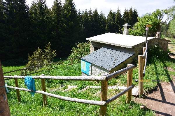
Mountain refuge Cabane Oller
We have it listed in the app!
We have it listed in the app!


At 1825 meters above sea level, nestled in refuge oller, route forestière colbert, quérigut, foix, ariège, occitania, francia metropolitana, 09460, francia, stands the Cabane Oller refuge. It is the perfect stop to spend the night or catch your breath. GPS coordinates: 42.656, 2.153.
10.1°C
Feels like: 7.8°C10.2 km/h
Gusts: 18.4 km/h4210 m
Snow lineUV 1.05
Clouds: 100% 20.5 mm
 15 km/h
 UV máx: 5.1
 06:14
06:14
 21:24
0.2 mm
13.6 km/h
UV máx: 8.05
06:14
21:25
0 mm
10.6 km/h
UV máx: 6.85
06:14
21:26
4 mm
10.2 km/h
UV máx: 7.7
06:13
21:26
5.1 mm
13.4 km/h
UV máx: 7.65
06:13
21:27
2.4 mm
7.9 km/h
UV máx: 7.45
06:13
21:27
0.6 mm
8.3 km/h
UV máx: 7.75
06:13
21:28
21:24
0.2 mm
13.6 km/h
UV máx: 8.05
06:14
21:25
0 mm
10.6 km/h
UV máx: 6.85
06:14
21:26
4 mm
10.2 km/h
UV máx: 7.7
06:13
21:26
5.1 mm
13.4 km/h
UV máx: 7.65
06:13
21:27
2.4 mm
7.9 km/h
UV máx: 7.45
06:13
21:27
0.6 mm
8.3 km/h
UV máx: 7.75
06:13
21:28
Cabane Oller is located in the surroundings of Quérigut, in Occitania, within the eastern Pyrenean sector where Ariège, Aude and Eastern Pyrenees converge. This position brings it closer to the Sierra de Madrès , a wide and open relief massif that functions as a passing area between valleys and high plateaus. At 1.825 meters, the atmosphere is already clearly mountainous and weather can change quickly, especially when dark, wind or storms enter.
More than a shelter linked to a single ascent, its interest is in road planning and the continuity of days on this part of the French Pyrenees. In a territory of high slopes, lomas and forests, Cabane Oller can be used as a support for long routes or for cross-roads linking different sectors of the massif. This utility requires good management of the effort in the approach and not to be trusted with the logistics: the registered sources are left from about 2.8 km, so it is necessary to go out with sufficient water or to provide with a margin where to resupply.
In the area they pass itineraries like the Chemin Vauban and Tour du Capcir in addition to the PR31 Les rhododendrons , which reinforces its role as an intermediate reference rather than an isolated destination. The combination of moderate altitude, exposure and distance to water points recommends preparing the day with mountain criteria: careful orientation, time margin and equipment adapted to time changes, especially if it is proposed as a link between routes or as an intermediate night on a journey.


📏 0 Km
⛰️ 1810 m
📏 0.8 Km
⛰️ 1570 m

📏 1.5 Km
⛰️ 2469 m

📏 2.9 Km
⛰️ 1870 m

📏 3.1 Km
⛰️ 2420 m

📏 3.2 Km
⛰️ 1849 m

📏 3.4 Km
⛰️ 1865 m

📏 3.5 Km
⛰️ 1792 m
Download the app and start looking for the shelter of your next adventure


Find a place to sleep before night falls.


