Mountain refuge Refuge de Bècet

We have it listed in the app!


            Mountain refuge Refuge de Bècet in refuge de bécet, route forestière colbert, quérigut, foix, ariège, occitania, francia metropolitana, 09460, francia
Five orange stars in a horizontal row representing a five-star rating.

Refuge de Bècet

Lat: 42.656xxx – Lon: 2.144xxx
📍 refuge de bécet, route forestière colbert, quérigut, foix, ariège, occitania, francia metropolitana, 09460, francia
Refuge de Bècet

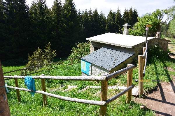
If you are planning a route through refuge de bécet, route forestière colbert, quérigut, foix, ariège, occitania, francia metropolitana, 09460, francia, the Refuge de Bècet refuge is a must-stop. Located at 1570 m above sea level, it offers hikers and climbers a safe place to regain strength. Save its coordinates (42.656, 2.144) in your GPS to stay on course during your journey.

See more
See more
Usuario

Lucas Martinez

Premium user

Live weather: Refuge de Bècet

Live weather report for Refuge de Bècet: current 9.9°C at 1570 meters (feels like 9.7°C). Wind at 1.5 km/h with gusts that may reach 6.1 km/h. The freezing level is at 4490 m and the maximum temperature will be 16.1°C.
Temperature

9.9°C

Feels like: 9.7°C
Wind

1.5 km/h

Gusts: 6.1 km/h
Freezing level 0°

4490 m

Snow line
Sky & UV

UV 0

Clouds: 100%

Next 48 hours evolution

7-day forecast

03/06
16.1° 5.3°
0 mm 11.2 km/h UV máx: 8
06:15 21:24
04/06
18.1° 6.2°
8.5 mm 23.2 km/h UV máx: 5
06:14 21:24
05/06
11.2° 3.1°
0.1 mm 14 km/h UV máx: 7.65
06:14 21:25
06/06
16.9° 6.4°
0.5 mm 13.8 km/h UV máx: 6.9
06:14 21:26
07/06
20.6° 9.1°
2.67 mm 10 km/h UV máx: 7.1
06:13 21:26
08/06
15.8° 8.4°
5.4 mm 12 km/h UV máx: 7.9
06:13 21:27
09/06
10.6° 5.3°
0.6 mm 15.2 km/h UV máx: 3.25
06:13 21:27

Between the forests and lomas of the Quérigut sector, in the contact between Ariège and the surroundings of the Caprir, the land is gaining mountainous character as it moves away from the tracks and approaches the rounded and rocky peaks of the Eastern Pyrenees. In this context, the Bècet Refuge a useful support to raise a day with more margin in an area where the relief is not always extreme, but it is wide and dispersed enough to demand good reading of the route and forecast of the weather.

This free shelter is located at 1570 meters, in the area of the route forestière Colbert, and fits well as a point of passage or support for different length paths. They pass by like the Chemin Vauban and Tour du Capcir in addition to the PR31 Les rhododendrons, which reinforces their role within linked routes rather than as a simple isolated destination. It is precisely because of this mountain use that it is necessary to plan with autonomy: the nearest invented sources are just over 2 km away, so it is not wise to have immediate water next to the shelter without having checked it before.

To the higher levels, the presence of nearby elevations like Roc Mary, Roc de Nou Fonts o Roc Negre helps to understand the medium and high mountain environment around the area. It is not just about adding summits, but about moving on a land where the real distance can be extended according to the state of the path, the continuity of the marks or the conditions of the day. For those who use the shelter as a base or as an intermediate stage, it makes more sense to think about effort management, water and guidance than a short or purely recreational approach.

Hiking routes from the refuge

Local

Chemin Vauban

↔ Variable distance
PR31

Les rhododendrons

↔ 7 km
Local

Tour du Capcir

↔ Variable distance
CC-C

El Camí IT1TR4 El Camí Capçaler: de Salzes a Balaguer

↔ Variable distance
CC-C

El Camí IT1TR5 El Camí Capçaler: de Salzes a Balaguer

↔ Variable distance

Nearby peaks

Roc de Nou Fonts

2333 m
Lat: 42.6541 Lon: 2.1805

Roc Mary

Altitude not available
Lat: 42.6528 Lon: 2.1694

Roc Negre

2450 m
Lat: 42.6513 Lon: 2.2015

Salt del Burro

Altitude not available
Lat: 42.6572 Lon: 2.1977

El Roc Gros

Altitude not available
Lat: 42.6025 Lon: 2.1558

Pic de l'Orry

1918 m
Lat: 42.6176 Lon: 2.1487

Pic des Agrellons

1936 m
Lat: 42.6125 Lon: 2.1481

Roc de la Couillade del Peyroulet

Altitude not available
Lat: 42.6661 Lon: 2.0916

Nearby water fountains

Fuente

2.11 Km
Lat: 42.6661 Lon: 2.0916

Fuente

2.15 Km
Lat: 42.6661 Lon: 2.0916

Fuente

2.21 Km
Lat: 42.6661 Lon: 2.0916

Fontaine Sainte-Marie

4.57 Km
Lat: 42.6661 Lon: 2.0916

Fuente

5.61 Km
Lat: 42.6661 Lon: 2.0916

Fuente

5.63 Km
Lat: 42.6661 Lon: 2.0916

Fuente

5.72 Km
Lat: 42.6661 Lon: 2.0916

Fuente

7.75 Km
Lat: 42.6661 Lon: 2.0916
FAQ

Frequently asked questions

Pregunta frecuente
Is it necessary to carry a GPS to reach the Refuge de Bècet refuge?
It is always highly recommended to carry a GPS device, a route track, or a topographic map in the mountains. You can use the coordinates 42.656, 2.144 to locate this refuge precisely.
Pregunta frecuente
In which municipality or region is the Refuge de Bècet refuge located?
This refuge is located within the municipality of Quérigut, belonging to the community or region of Occitania.
Pregunta frecuente
Are there other mountain refuges near Refuge de Bècet?
Yes, nearby you can find other options to spend the night or take shelter. El refugio más próximo es el Cabane Oller, que se encuentra a aproximadamente 0.8 km de distancia.
More areas

Other areas

Collaborative

Together we improve

image

Send your photos

You can upload photos of shelters and update their status so other users know if they can go there.

Get started
Get started
image

Rate the shelter

Leave your comments to rate the shelter’s condition. In the mountains, we look after each other.

Get started
Get started
image

Add new ones

Did we miss any? Publish the shelters you know so everyone can use them.

Get started
Get started
Download for free from the Apple App Store and Play Store.

Download the app and start looking for the shelter of your next adventure

Aplicación móvil para encontrar refugios de montaña donde dormir
Aplicación móvil para encontrar refugios de montaña donde dormir.
Mapa interactivo de refugios de montaña en los Pirineos dentro de la app
Mapa de refugios de montaña para senderismo y trekking en la app.
Pantalla con información de refugio de montaña con altitud capacidad y servicios
Pantalla con información de refugio de montaña con altitud capacidad y servicios.
Detalles de refugio de montaña con servicios y meteorología en aplicación móvil
Detalles de refugio de montaña con servicios y meteorología en aplicación móvil.
Aplicación para explorar refugios de montaña mediante mapa interactivo
Aplicación para explorar refugios de montaña mediante mapa interactivo.
Ficha completa de refugio de montaña con opiniones y servicios
Ficha completa de refugio de montaña con opiniones y servicios.
Información detallada de refugio en app para montañeros
Información detallada de refugio en app para montañeros.
Listado de refugios de montaña para senderismo y trekking
Listado de refugios de montaña para senderismo y trekking.
Explorar refugios de montaña desde una aplicación móvil
Explorar refugios de montaña desde una aplicación móvil.