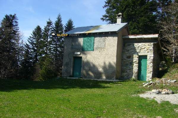
Mountain refuge Cabane Edf
We have it listed in the app!
We have it listed in the app!


Located at 833 m above sea level, the Cabane Edf refuge is a true haven of peace in d 22, orgeix, foix, ariège, occitania, francia metropolitana, 09110, francia. Connect with nature and use its coordinates (42.705, 1.869) to guide your steps to its door.
16.3°C
Feels like: 15.9°C2.5 km/h
Gusts: 4 km/h4010 m
Snow lineUV 2.65
Clouds: 100% 22.55 mm
 13.3 km/h
 UV máx: 4.7
 06:15
06:15
 21:25
0.5 mm
7.4 km/h
UV máx: 6.4
06:15
21:26
0.5 mm
9.7 km/h
UV máx: 7.2
06:15
21:27
0.6 mm
7.4 km/h
UV máx: 7.3
06:14
21:27
6 mm
8.3 km/h
UV máx: 7.75
06:14
21:28
4.2 mm
7.5 km/h
UV máx: 1.9
06:14
21:29
1.2 mm
5.6 km/h
UV máx: 7.4
06:14
21:29
21:25
0.5 mm
7.4 km/h
UV máx: 6.4
06:15
21:26
0.5 mm
9.7 km/h
UV máx: 7.2
06:15
21:27
0.6 mm
7.4 km/h
UV máx: 7.3
06:14
21:27
6 mm
8.3 km/h
UV máx: 7.75
06:14
21:28
4.2 mm
7.5 km/h
UV máx: 1.9
06:14
21:29
1.2 mm
5.6 km/h
UV máx: 7.4
06:14
21:29
The easiest thing to expect here is the general orientation of the place: the Cabane Edf appears next to the D22, in the environment of Orgeix , in Ariège, at 833 meters altitude. This point does not yet refer to a high-rise shelter, but to an access position on the low and medium mountain of the Ax-les-Thermes sector, useful to enter into more closed pyrenean terrain before gaining height to slopes, forests and side valleys.
The nearby relief helps you read your role. In the vicinity, references such as Pic du Mont or Cap de Carbone , summits that announce a landscape that fits and is quickly packed within walking distance of the valley bottom. That is why this coat fits more as a transitional support than as the end of the day in a strictly alpine environment: it serves to be at the foot of a land that soon changes its scale and that can become more demanding as you leave the road and enter mountain itineraries.
It is also a more connected passage area than your name may suggest. They run around like the GR 10 as well as local routes to L'Étang d'En Beys and other links in the sector. This gives him interest as a basic point of support for those who combine signposted paths with shorter routes through the valley, or to divide an approach before continuing to higher levels. The practical utility depends, in any case, on planning the specific route well, because the distances available for several routes are variable and do not allow to deduce times or real effort.
In the logistics part, there is a clear fact: there are relatively close sources, with one to about 270 meters and one to less than 400. However, on the mountain it is appropriate not to be sure its availability at any time and to carry a water margin or confirm the point of supply before leaving. Since there is no detailed information on equipment or conditions of use here, it is reasonable to have autonomy, especially if it is proposed as a support shelter on a long day or with changing weather.
More than a destination in itself, this coat is better understood as a modest piece within the network of accesses of the high Ariège: close to the inhabited core, connected to known routes and located on a level from which the landscape begins to transform into a more mountainous terrain.


📏 2.6 Km
⛰️ 1500 m

📏 2.6 Km
⛰️ 1280 m

📏 2.8 Km
⛰️ 1702 m

📏 3.4 Km
⛰️ 1380 m

📏 3.4 Km
⛰️ 1300 m
📏 3.4 Km
⛰️ 1541 m

📏 4.4 Km
⛰️ 1486 m

📏 4.4 Km
⛰️ 1500 m
Download the app and start looking for the shelter of your next adventure


Find a place to sleep before night falls.


