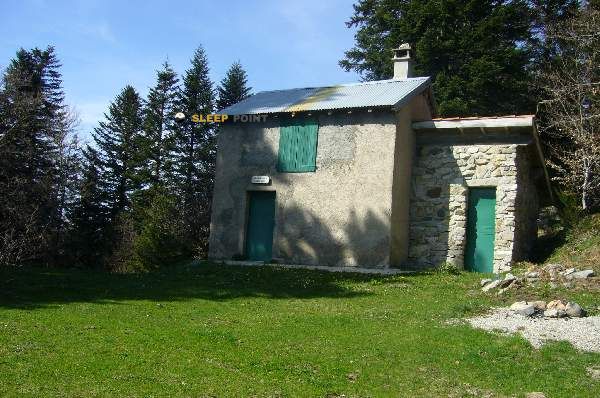
Mountain refuge Orri de Cizarols
We have it listed in the app!
We have it listed in the app!


Located at 1500 m above sea level, the Orri de Cizarols refuge is a true haven of peace in orri de cizarols, chemin du liata, ax-les-thermes, foix, ariège, occitania, francia metropolitana, 09110, francia. Connect with nature and use its coordinates (42.666, 1.876) to guide your steps to its door.
10°C
Feels like: 9.3°C4.3 km/h
Gusts: 3.6 km/h4480 m
Snow lineUV 0
Clouds: 100% 28.1 mm
 19.9 km/h
 UV máx: 4.7
 06:15
06:15
 21:25
0.4 mm
7.9 km/h
UV máx: 7.85
06:15
21:26
0.4 mm
13.5 km/h
UV máx: 7
06:15
21:27
1 mm
7.2 km/h
UV máx: 7.1
06:14
21:27
5.4 mm
9.4 km/h
UV máx: 8
06:14
21:28
0.6 mm
9 km/h
UV máx: 2.35
06:14
21:29
1.2 mm
7.6 km/h
UV máx: 7.75
06:14
21:29
21:25
0.4 mm
7.9 km/h
UV máx: 7.85
06:15
21:26
0.4 mm
13.5 km/h
UV máx: 7
06:15
21:27
1 mm
7.2 km/h
UV máx: 7.1
06:14
21:27
5.4 mm
9.4 km/h
UV máx: 8
06:14
21:28
0.6 mm
9 km/h
UV máx: 2.35
06:14
21:29
1.2 mm
7.6 km/h
UV máx: 7.75
06:14
21:29
In this part of the Ariège, above the environment of Ax-les-Thermes the passage from one side to another and the continuity of one journey weigh more than the idea of refuge as a destination in itself. About 1,500 meters, Orri de Cizarols best fit as basic support within a day of liaison, in an area where long-distance routes and variants connect different aspects of the Eastern Pyrenees.
Their practical interest is in this intermediate position: close to the GR 7 of a variant of the HRP and the pyrenaic axis of GR 10 , can be used to break a stage or to reorganize a route when time changes and it is appropriate not to extend the day too long. It also falls within the scope of the itinerary to the Étang d'En Beys , usual reference on this mountain of lakes, loins and steps between valleys.
The near relief helps to understand its character. It is not in a comfortable valley background, but in a sector that already clearly looks at mountain terrain, with close peaks like the Cap de Carbone and, beyond, elevations of more entity like the Pic Lanoux or Pic d'Étang Faury . This suggests a transition environment to higher levels, useful to gain ground before hills, lakes or crest, but also more exposed to rapid changes in fog, wind or rain.
It should be planned with an autonomous mind. There are no data here that allow for specific equipment or immediate supply, and the registered sources are several kilometres away, not next to the coat. Therefore, to use this mountain shelter within a route planning, it is reasonable to go out with sufficient water, reliable map or track and scope to adapt the day if the terrain or weather force to modify the intended link.
More than a long stay point, it works as a discreet reference in a network of itineraries where the general orientation of the journey matters a lot: deciding whether to continue towards a pirenaic journey, whether to connect with another valley or if to cut stage before entering higher ground.


📏 0.1 Km
⛰️ 1486 m

📏 1 Km
⛰️ 1637 m

📏 1.1 Km
⛰️ 1300 m

📏 1.1 Km
⛰️ 1380 m

📏 1.9 Km
⛰️ 1280 m

📏 1.9 Km
⛰️ 1702 m

📏 2.6 Km
⛰️ 1792 m
📏 3 Km
⛰️ 1541 m
Download the app and start looking for the shelter of your next adventure


Find a place to sleep before night falls.


