Mountain refuge Chalet forestier de Courtal-Jouan

We have it listed in the app!


            Mountain refuge Chalet forestier de Courtal-Jouan in chalet forestier de courtal-jouan, chemin du llata, mérens-les-vals, foix, ariège, occitania, francia metropolitana, 09110, francia
Five orange stars in a horizontal row representing a five-star rating.

Chalet forestier de Courtal-Jouan

Lat: 42.68xxx – Lon: 1.846xxx
📍 chalet forestier de courtal-jouan, chemin du llata, mérens-les-vals, foix, ariège, occitania, francia metropolitana, 09110, francia
Chalet forestier de Courtal-Jouan

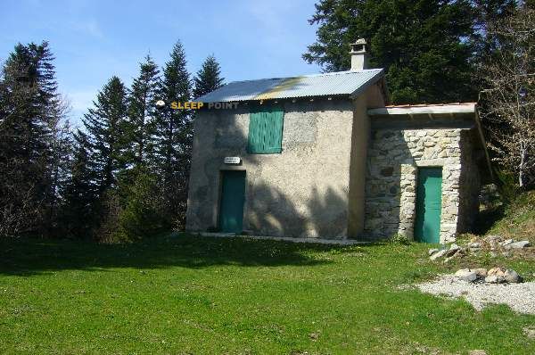
Prepare your backpack and head to chalet forestier de courtal-jouan, chemin du llata, mérens-les-vals, foix, ariège, occitania, francia metropolitana, 09110, francia. There you will find the Chalet forestier de Courtal-Jouan refuge at 1541 meters of elevation. An essential stop along the way (Lat: 42.68, Lon: 1.846) for any mountain enthusiast.

See more
See more
Usuario

Lucas Martinez

Premium user

Live weather: Chalet forestier de Courtal-Jouan

The current weather in Chalet forestier de Courtal-Jouan indicates a temperature of 14.9°C, although the 1.9 km/h wind makes it feel like 14.1°C. Watch out for gusts of 7.6 km/h. The snow altitude (freezing level 0°) is around 4290 m and today we will reach a high of 15.9°C.
Temperature

14.9°C

Feels like: 14.1°C
Wind

1.9 km/h

Gusts: 7.6 km/h
Freezing level 0°

4290 m

Snow line
Sky & UV

UV 4.1

Clouds: 100%

Next 48 hours evolution

7-day forecast

04/06
15.9°
26.35 mm 12 km/h UV máx: 5.1
06:16 21:25
05/06
10.9° 2.5°
1.3 mm 13.3 km/h UV máx: 7.9
06:15 21:26
06/06
18.1° 6.3°
0 mm 8.7 km/h UV máx: 7.2
06:15 21:27
07/06
22.4° 8.9°
1.7 mm 8.6 km/h UV máx: 7.7
06:15 21:28
08/06
21.8° 12.9°
15.3 mm 8.6 km/h UV máx: 8
06:14 21:28
09/06
12.9° 7.2°
2.1 mm 8.4 km/h UV máx: 5.2
06:14 21:29
10/06
13.7° 8.1°
1.2 mm 7.6 km/h UV máx: 7.6
06:14 21:29

Between Mérenses-les-Vals and the Ariège's cords

At 1541 meters, Villa forester de Courtal-Jouan it is located in a mountain strip where the forest gives way to more open slopes and to reliefs that link valleys, loins and secondary tops of the surroundings of Mérens-les-Vals. Its position, in the sector of the chemin du Llata, places it in a useful area to orient between the valley bottom and the elevations that close this stretch of the Ariège. References such as Cap de Carbone and Pic de Truseilles which help to understand the mountainous character of the sector and the progressive exposure to time as you gain height.

More than an isolated destination, it works as a support within a network of itineraries that combines local routes with pirenaic crossing. The presence of GR 10 In the vicinity it strengthens its interest to divide days or link steps between valleys on a long route along the northern side of the Pyrenees. In addition, there are signposted paths of the environment, such as the routes to Couillet de Bergon or the local routes of the Ax and Mérens sector, which expand the options of approach or link without making the place an exclusively passing point.

It should be raised as mountain shelter basic support and with prudent planning. The altitude is not extreme, but is sufficient to notice rapid changes in meteorology, wet or cold terrain out of season and a greater sense of isolation than the map suggests. There are no immediate sources next to the shelter according to the available data; the nearest ones are more than 2 km away, so it is reasonable to bring sufficient water and not to depend on the supply in the place. It is also sensible to review the status of access and foresight before leaving, especially if it is intended to link hills or long routes.

Hiking routes from the refuge

GR 10

La traversée des Pyrénées - sec.3

↔ 110 km
GR 10

La traversée des Pyrénées - sec.2

↔ Variable distance
N20

N20 Sources Sulfureuses

↔ Variable distance
N21

N21 Couillet de Bergon

↔ Variable distance
Local

Petches Ax

↔ Variable distance
AX30

Tour du Roc de l'Orri d'Ignaux

↔ Variable distance
AX34

La Dent d'Orlu

↔ Variable distance
AX14

La Porteille d'Orgeix

↔ Variable distance

Nearby peaks

Pic de L'Homme

Altitude not available
Lat: 42.6417 Lon: 1.8903

Castel Maou

815 m
Lat: 42.7149 Lon: 1.8379

Cap de Carbone

1857 m
Lat: 42.6676 Lon: 1.8595

Pic de Truseilles

2038 m
Lat: 42.6411 Lon: 1.8524

Pic Esteille

2332 m
Lat: 42.6334 Lon: 1.857

Sarrat de l'Étang

1127 m
Lat: 42.7141 Lon: 1.8594

Tute de l'Ours

2255 m
Lat: 42.6665 Lon: 1.7956

Pic des Perdix

2301 m
Lat: 42.6453 Lon: 1.8766

Nearby water fountains

Fuente

2.46 Km
Lat: 42.6453 Lon: 1.8766

Fuente

2.64 Km
Lat: 42.6453 Lon: 1.8766

Fuente

2.67 Km
Lat: 42.6453 Lon: 1.8766

Fuente

2.67 Km
Lat: 42.6453 Lon: 1.8766

Fuente

2.75 Km
Lat: 42.6453 Lon: 1.8766

Fuente

2.84 Km
Lat: 42.6453 Lon: 1.8766

Fuente

2.85 Km
Lat: 42.6453 Lon: 1.8766

Fuente

3.36 Km
Lat: 42.6453 Lon: 1.8766
FAQ

Frequently asked questions

Pregunta frecuente
Is it necessary to carry a GPS to reach the Chalet forestier de Courtal-Jouan refuge?
It is always highly recommended to carry a GPS device, a route track, or a topographic map in the mountains. You can use the coordinates 42.68, 1.846 to locate this refuge precisely.
Pregunta frecuente
In which municipality or region is the Chalet forestier de Courtal-Jouan refuge located?
This refuge is located within the municipality of Mérens-les-Vals, belonging to the community or region of Occitania.
Pregunta frecuente
Are there other mountain refuges near Chalet forestier de Courtal-Jouan?
Yes, nearby you can find other options to spend the night or take shelter. El refugio más próximo es el Borde de Gabriel, que se encuentra a aproximadamente 0.9 km de distancia.
More areas

Other areas

Collaborative

Together we improve

image

Send your photos

You can upload photos of shelters and update their status so other users know if they can go there.

Get started
Get started
image

Rate the shelter

Leave your comments to rate the shelter’s condition. In the mountains, we look after each other.

Get started
Get started
image

Add new ones

Did we miss any? Publish the shelters you know so everyone can use them.

Get started
Get started
Download for free from the Apple App Store and Play Store.

Download the app and start looking for the shelter of your next adventure

Aplicación móvil para encontrar refugios de montaña donde dormir
Aplicación móvil para encontrar refugios de montaña donde dormir.
Mapa interactivo de refugios de montaña en los Pirineos dentro de la app
Mapa de refugios de montaña para senderismo y trekking en la app.
Pantalla con información de refugio de montaña con altitud capacidad y servicios
Pantalla con información de refugio de montaña con altitud capacidad y servicios.
Detalles de refugio de montaña con servicios y meteorología en aplicación móvil
Detalles de refugio de montaña con servicios y meteorología en aplicación móvil.
Aplicación para explorar refugios de montaña mediante mapa interactivo
Aplicación para explorar refugios de montaña mediante mapa interactivo.
Ficha completa de refugio de montaña con opiniones y servicios
Ficha completa de refugio de montaña con opiniones y servicios.
Información detallada de refugio en app para montañeros
Información detallada de refugio en app para montañeros.
Listado de refugios de montaña para senderismo y trekking
Listado de refugios de montaña para senderismo y trekking.
Explorar refugios de montaña desde una aplicación móvil
Explorar refugios de montaña desde una aplicación móvil.