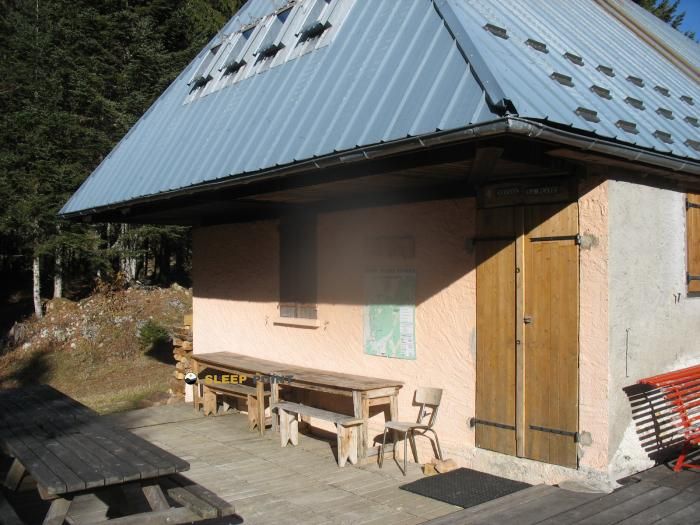
Mountain refuge Refuge du Creux de Lachat
We have it listed in the app!
We have it listed in the app!


The Refuge du Creux de Lachat refuge stands at 1361 meters above sea level, overlooking the surroundings of refuge du creux de lachat, chemin du refuge du creux de lachat, chalets du creux de lachat, arith, chambéry, saboya, auvergne-rhône-alpes, francia metropolitana, 73340, francia. It is a key spot for mountaineers looking to spend the night or take a break. Its coordinates (45.722, 6.035) place it in a strategic position for exploring the peaks and trails of the region.
9.7°C
Feels like: 7.7°C4.7 km/h
Gusts: 23 km/h3750 m
Snow lineUV 0.2
Clouds: 100% 32.4 mm
 20.7 km/h
 UV máx: 4.3
 05:48
05:48
 21:20
19.6 mm
10 km/h
UV máx: 5.85
05:47
21:21
0.1 mm
8.9 km/h
UV máx: 7.45
05:47
21:21
0 mm
6.2 km/h
UV máx: 6.75
05:47
21:22
0 mm
7.4 km/h
UV máx: 6.35
05:46
21:23
1.65 mm
9.4 km/h
UV máx: 4.8
05:46
21:23
0 mm
8.2 km/h
UV máx: 7.25
05:46
21:24
21:20
19.6 mm
10 km/h
UV máx: 5.85
05:47
21:21
0.1 mm
8.9 km/h
UV máx: 7.45
05:47
21:21
0 mm
6.2 km/h
UV máx: 6.75
05:47
21:22
0 mm
7.4 km/h
UV máx: 6.35
05:46
21:23
1.65 mm
9.4 km/h
UV máx: 4.8
05:46
21:23
0 mm
8.2 km/h
UV máx: 7.25
05:46
21:24
In this part of Savoy, the shelter fits better as stage support than as a simple, isolated coat. The presence of GR 96 and of several hiking itineraries in the surrounding area places it in a transit area where it can serve both to break a day and to link along the hill and half-mountain forests. Its location, in the area of the villa du Creux de Lachat and near Arith, relates it more to cross-roads and links between valleys than to a single linear access.
At 1361 meters, the environment does not respond to the high classical pirenaic mountain, but it does respond to a relief exposed to rapid changes in time, fog and variations in visibility that can complicate the orientation in a long day. In the surrounding area there are levels as Crêt de la Dolca or La Culaz enough to understand that the progression combines soft sections with direction changes and small highlights that make it necessary to read the ground well. In this context, the shelter can function as a basis for short exits or as a point of passage within a wider journey.
It is also useful for those looking for close routes of a circular nature, although the main interest is in stage planning and not in cumulation. The proximity of itineraries such as the Balcon du Semnoz or the Bouchle du Chaos du Chéran reinforces this idea of a senderist node, with options of continuity in several directions.
With a view to logistics, a certain autonomy should be maintained. There is a source at about 140 meters, practical data to adjust water in route, but in mountain it is always reasonable to foresee changes in flow or variable conditions. With unstable weather, the sector may feel more exposed than its altitude suggests, especially if it is linked with long routes or through open areas.


📏 0.6 Km
⛰️ 1325 m

📏 0.7 Km
⛰️ 1295 m

📏 1.1 Km
⛰️ 995 m

📏 2 Km
⛰️ 1350 m

📏 2.3 Km
⛰️ 1350 m

📏 2.4 Km
⛰️ 1245 m
📏 2.7 Km
⛰️ 1300 m

📏 3 Km
⛰️ 1109 m
Download the app and start looking for the shelter of your next adventure


Find a place to sleep before night falls.


