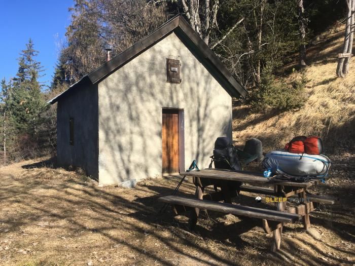
Mountain refuge Chapelle Notre Dame des Neiges de Charcherie
We have it listed in the app!
We have it listed in the app!

At 1424 meters above sea level, nestled in le grand champ, chemin de charcherie, les vernets, seyne, digne-les-bains, alpes de alta provenza, provenza-alpes-costa azul, francia metropolitana, 04140, francia, stands the Chapelle Notre Dame des Neiges de Charcherie refuge. It is the perfect stop to spend the night or catch your breath. GPS coordinates: 44.315, 6.364.
8.8°C
Feels like: 6.8°C2.2 km/h
Gusts: 5 km/h4230 m
Snow lineUV 0
Clouds: 100% 13.5 mm
 17 km/h
 UV máx: 7.1
 05:52
05:52
 21:13
0.4 mm
14.6 km/h
UV máx: 7.4
05:51
21:14
0 mm
13.4 km/h
UV máx: 7.95
05:51
21:15
0 mm
11.2 km/h
UV máx: 7.7
05:51
21:15
0 mm
15.3 km/h
UV máx: 7.3
05:50
21:16
0 mm
13.7 km/h
UV máx: 6.65
05:50
21:17
0 mm
11.6 km/h
UV máx: 7.65
05:50
21:17
21:13
0.4 mm
14.6 km/h
UV máx: 7.4
05:51
21:14
0 mm
13.4 km/h
UV máx: 7.95
05:51
21:15
0 mm
11.2 km/h
UV máx: 7.7
05:51
21:15
0 mm
15.3 km/h
UV máx: 7.3
05:50
21:16
0 mm
13.7 km/h
UV máx: 6.65
05:50
21:17
0 mm
11.6 km/h
UV máx: 7.65
05:50
21:17
At 1,424 meters, in the surroundings of Charcherie and Les Vernets, within the term of Seyne , this coat fits mainly in a plan of withdrawal, link or day division rather than in a service-based stay. Its position in the Alpes de Alta Provence places it close to several passing routes, including the axis that rises from Seyne towards the Col du Roburent and various pastoral roads in the area. For those who travel the mountain with the idea of keeping options open, having this point located can be useful if the weather changes, if the day is extended or if it is appropriate to cut a long journey without losing entirely the continuity of the itinerary.
The surrounding terrain responds to a medium-high mountain of alpine transition, with nearby reliefs that clearly exceed the level of the shelter, as Tourtourel o Clot de bouc, which helps to understand a landscape of slopes, steps and pastoral tours where the orientation and management of the effort matter more than the pure technical difficulty. There are no data to allow for internal equipment or immediate supply, so it is appropriate to propose the output with autonomy. The nearest registered source is just over 2 km away, sufficient distance not to give the water for safety during the march if you arrive just from reservations. In this type of shelter, the main value is in its on-the-road support function and in providing a clear reference within a network of roads where retreat on time can be as important as moving forward.


📏 4.8 Km
⛰️ 1150 m

📏 5.7 Km
⛰️ 1721 m
📏 5.7 Km
⛰️ 1695 m

📏 5.8 Km
⛰️ 1126 m

📏 6.6 Km
⛰️ 1775 m

📏 6.7 Km
⛰️ 1565 m

📏 6.8 Km
⛰️ 1705 m

📏 7.3 Km
⛰️ 1812 m
Download the app and start looking for the shelter of your next adventure


Find a place to sleep before night falls.


