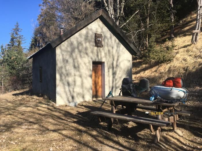
Mountain refuge Cabane des Mulets
We have it listed in the app!
We have it listed in the app!


Discover the vastness of cabane des mulets, chemin de la cabane des mulets, seyne, digne-les-bains, alpes de alta provenza, provenza-alpes-costa azul, francia metropolitana, 04140, francia by spending the night at the Cabane des Mulets refuge. It sits at 1721 meters, offering a unique balcony over the natural landscape. Find it on the map at latitude 44.32 and longitude 6.435.
10.9°C
Feels like: 7.8°C8.8 km/h
Gusts: 15.5 km/h4210 m
Snow lineUV 0
Clouds: 86% 29.3 mm
 26.1 km/h
 UV máx: 7.9
 05:51
05:51
 21:13
0.1 mm
14.1 km/h
UV máx: 7.35
05:51
21:14
0 mm
16 km/h
UV máx: 8
05:51
21:14
0 mm
14.5 km/h
UV máx: 7.9
05:50
21:15
0 mm
19.1 km/h
UV máx: 7.95
05:50
21:16
0 mm
13.7 km/h
UV máx: 7.15
05:50
21:16
0 mm
11.6 km/h
UV máx: 7.7
05:50
21:17
21:13
0.1 mm
14.1 km/h
UV máx: 7.35
05:51
21:14
0 mm
16 km/h
UV máx: 8
05:51
21:14
0 mm
14.5 km/h
UV máx: 7.9
05:50
21:15
0 mm
19.1 km/h
UV máx: 7.95
05:50
21:16
0 mm
13.7 km/h
UV máx: 7.15
05:50
21:16
0 mm
11.6 km/h
UV máx: 7.7
05:50
21:17
At 1,721 metres, Cabane des Mulets fits better in a day planning than in a simple reference on the map. Its position, in the surroundings of Seyne and within the mountains of Alta Provence, places it in a strip where the terrain already requires reading of the itinerary, room for time changes and careful management of the effort if it comes from lower levels.
In this area, the shelter works mainly as a point of passage or support for mountain and cross-country tours. The closeness of the GR 56 Tour de l'Ubaye it relates to routes of greater continuity, while pastoral roads such as the Col de Bernardez help you understand your role in a network of steps and links rather than as an isolated destination. This combination makes it useful to divide stages or to propose a margin approach before winning more open hills and slopes.
The near relief reinforces that mountain character. Summits like Roche Close , very close, or Puy de la Sèche They mark a medium and high mountain environment where orientation, wind and weather evolution can weigh more than the distance itself. The altitude is not extreme, but it is sufficient for a day to change much according to the time, state of the land or the load taken.
For autonomy, there is a fountain practically next to the cabin, a few meters away, a valuable data at this point. Even so, it is appropriate not to base the whole day on a single point of water without checking recent conditions. If it is proposed as a support mountain shelter on the way, it is reasonable to reach with margin, water reserve and alternative plan to fog, wind or rapid time changes.


📏 3.4 Km
⛰️ 2250 m

📏 3.6 Km
⛰️ 1775 m
📏 3.9 Km
⛰️ 1695 m

📏 3.9 Km
⛰️ 1745 m

📏 4 Km
⛰️ 2066 m

📏 4 Km
⛰️ 1812 m

📏 4.8 Km
⛰️ 1565 m

📏 5.6 Km
⛰️ 2260 m
Download the app and start looking for the shelter of your next adventure


Find a place to sleep before night falls.


