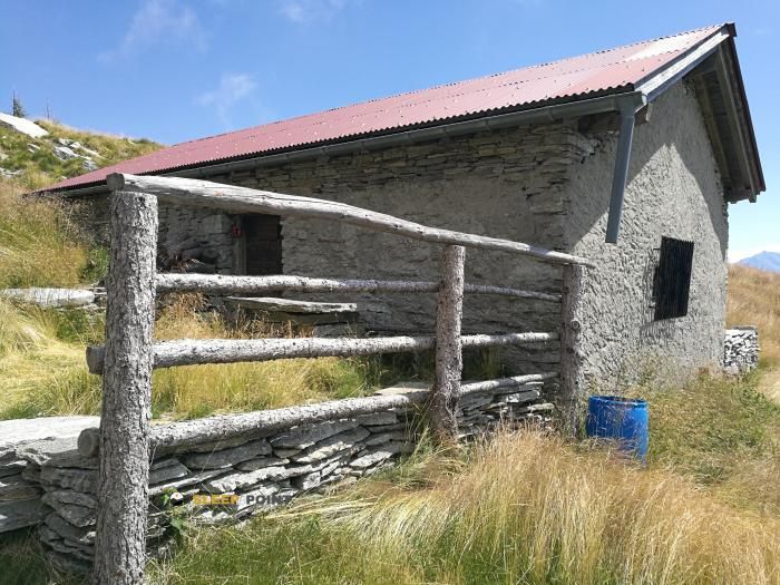
Mountain refuge Capanna Brogoldone
We have it listed in the app!
We have it listed in the app!


Prepare your backpack and head to capanna brogoldone, saurù - domàs - brogoldone, lumino, circolo di arbedo-castione, distretto di bellinzona, tesino, 6533, suiza. There you will find the Capanna Brogoldone refuge at 1910 meters of elevation. An essential stop along the way (Lat: 46.263, Lon: 9.063) for any mountain enthusiast.
7.3°C
Feels like: 4.8°C5.2 km/h
Gusts: 19.1 km/h3670 m
Snow lineUV 0.45
Clouds: 98% 20.1 mm
 13.4 km/h
 UV máx: 6.2
 05:33
05:33
 21:10
32.7 mm
7.6 km/h
UV máx: 7.45
05:33
21:11
8.2 mm
6.1 km/h
UV máx: 6.75
05:33
21:11
0 mm
7.7 km/h
UV máx: 6.15
05:32
21:12
2.1 mm
10 km/h
UV máx: 7.45
05:32
21:13
11.25 mm
11.6 km/h
UV máx: 5.75
05:32
21:13
0 mm
11.5 km/h
UV máx: 2.55
05:31
21:14
21:10
32.7 mm
7.6 km/h
UV máx: 7.45
05:33
21:11
8.2 mm
6.1 km/h
UV máx: 6.75
05:33
21:11
0 mm
7.7 km/h
UV máx: 6.15
05:32
21:12
2.1 mm
10 km/h
UV máx: 7.45
05:32
21:13
11.25 mm
11.6 km/h
UV máx: 5.75
05:32
21:13
0 mm
11.5 km/h
UV máx: 2.55
05:31
21:14
Between the journey routes of the Tesino, Capanna Brogoldone fits better as a step reference than as a simple, isolated coat. Your position on the mountain of Lumino , within the environment of Bellinzona and close to long routes such as E1 or Via Gottardo , places it in a useful strip for those who link days on high slopes over the valley. At 1910 meters, the atmosphere is already clearly montane: rapid changes in time, wind and fog can condition the orientation even on routes without absolute altitude, and it is appropriate to read the terrain with map and foresight before having the shelter as the only support.
The nearby relief reinforces that character of medium-high Alpine mountain, with nearby heights like Piz de Molinera less than a kilometre in a straight line, and other elevations that close the horizon to higher cords in the sector. More than a place linked to a single objective, it works as an intermediate point to divide stages, gain height over the Lumino valley or maintain a field crossing exposed to meteorology. In logistics, the most useful data is that there are sources within a radius of approximately 1.7 to 2 km, an assumed but not immediate distance; therefore it is not appropriate to take the water as it comes. If it is proposed as road support, it is wise to leave with sufficient autonomy and not to base the day on unconfirmed services or a water availability next to the building.


📏 1.3 Km
⛰️ 1890 m

📏 3.9 Km
⛰️ 1746 m

📏 6.5 Km
⛰️ 1594 m
📏 6.7 Km
⛰️ 1773 m

📏 6.9 Km
⛰️ 1844 m

📏 7.5 Km
⛰️ 1638 m

📏 7.8 Km
⛰️ 1575 m

📏 9.3 Km
⛰️ 1656 m
Download the app and start looking for the shelter of your next adventure


Find a place to sleep before night falls.


