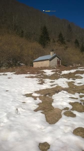
Mountain refuge Cabane des esquers du dessus
We have it listed in the app!
We have it listed in the app!


Located in the heart of cabane de la jasse des esquers du dessus, boulevard de la griole bas, savignac-les-ormeaux, foix, ariège, occitania, francia metropolitana, 09110, francia, the Cabane des esquers du dessus refuge offers shelter at 1350 meters above sea level. Ideal for trekking and nature lovers, this mountain shelter (Lat: 42.685, Lon: 1.781) is the perfect starting point or resting place for local routes.
11.2°C
Feels like: 10°C1.9 km/h
Gusts: 4 km/h4430 m
Snow lineUV 0
Clouds: 100% 14.7 mm
 11.2 km/h
 UV máx: 5.85
 06:16
06:16
 21:26
0.1 mm
9.2 km/h
UV máx: 7.6
06:15
21:26
0 mm
10.4 km/h
UV máx: 6.75
06:15
21:27
2 mm
7.6 km/h
UV máx: 6.85
06:15
21:28
5.7 mm
8.3 km/h
UV máx: 7.65
06:14
21:28
3.9 mm
7.4 km/h
UV máx: 5.7
06:14
21:29
0 mm
5.6 km/h
UV máx: 7.8
06:14
21:30
21:26
0.1 mm
9.2 km/h
UV máx: 7.6
06:15
21:26
0 mm
10.4 km/h
UV máx: 6.75
06:15
21:27
2 mm
7.6 km/h
UV máx: 6.85
06:15
21:28
5.7 mm
8.3 km/h
UV máx: 7.65
06:14
21:28
3.9 mm
7.4 km/h
UV máx: 5.7
06:14
21:29
0 mm
5.6 km/h
UV máx: 7.8
06:14
21:30
Cabane des esquers du dessus It fits better in a map reading than in an isolated stop: it appears in the surroundings of Savignac- les-Ormeaux, in the department of Ariège, 1350 meters, within a half mountain strip that serves as a transition to higher reliefs. From this sector, above the bottom of the valley and in an area connected with long-distance itineraries, the shelter works mainly as elementary support for those who advance through the Pyrenees and need to break a day or guard a journey.
Its interest is increased by the proximity of such traces as the HRP Variant 32.1 and various sections of the GR 10 , two clear references to understand your role as a step. It is not so much a shelter linked to a single objective as a useful point within a mountain corridor where you can find local routes and longer journeys. In the environment are raised tops like the Tute de l'Ours , Pic Redon or Pyramide de Lherbes , which help to draw a landscape of slopes, shoulders and elevations that gain alpine character as it rises from the valley.
It should be planned with an autonomous mind. The registered sources are several kilometres away, so it is not wise to have immediate water in the vicinity of the shelter without prior verification. No specific equipment or services should be involved. In an area such as this, open to time changes and with itineraries that can gradually link heights and hills, the main utility of the cabin is to offer a basic point of support within a route, rather than to solve the day's logistics on its own.


📏 1.1 Km
⛰️ 1264 m

📏 1.2 Km
⛰️ 1264 m

📏 1.3 Km
⛰️ 1480 m

📏 1.3 Km
⛰️ 1460 m

📏 1.5 Km
⛰️ 1700 m

📏 1.6 Km
⛰️ 1735 m

📏 1.9 Km
⛰️ 1501 m

📏 2.5 Km
⛰️ 1645 m
Download the app and start looking for the shelter of your next adventure


Find a place to sleep before night falls.


