Mountain refuge Cabane des Esquers du dessous
We have it listed in the app!
We have it listed in the app!


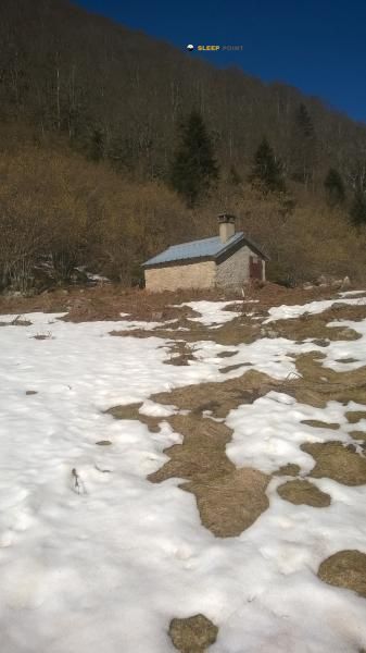
The mountains of cabane de la jasse des esquers du dessous, boulevard de la griole bas, savignac-les-ormeaux, foix, ariège, occitania, francia metropolitana, 09110, francia hide essential places like the Cabane des Esquers du dessous refuge. Situated at an elevation of 1264 meters, it offers protection and rest. Its exact coordinates are 42.695, 1.785.
10.1°C
Feels like: 9.9°C3.8 km/h
Gusts: 5.8 km/h4490 m
Snow lineUV 0
Clouds: 100% 16 mm
16 mm
 13.8 km/h
 UV máx: 5.5
 06:16
06:16
 21:26
0.4 mm
9.3 km/h
UV máx: 7.9
06:15
21:26
0 mm
10.4 km/h
UV máx: 6.55
06:15
21:27
2 mm
7.6 km/h
UV máx: 7.1
06:15
21:28
1.8 mm
7.9 km/h
UV máx: 8
06:14
21:28
1.5 mm
5.2 km/h
UV máx: 2.4
06:14
21:29
0 mm
5.1 km/h
UV máx: 7.8
06:14
21:30
21:26
0.4 mm
9.3 km/h
UV máx: 7.9
06:15
21:26
0 mm
10.4 km/h
UV máx: 6.55
06:15
21:27
2 mm
7.6 km/h
UV máx: 7.1
06:15
21:28
1.8 mm
7.9 km/h
UV máx: 8
06:14
21:28
1.5 mm
5.2 km/h
UV máx: 2.4
06:14
21:29
0 mm
5.1 km/h
UV máx: 7.8
06:14
21:30
Planning here begins with the near relief. In the environment of Cabane des Esquers du dessous several peaks that draw a terrain of medium and high mountain very immediate, with references like the Tute de l'Ours , Pic du Paille , Pic Baune or Pic de Belh . This concentration of elevations, within walking distance in a straight line, places the cabin in a useful strip for ascension days, links on high slopes or routes that seek to win cords on the valleys d'Ax.
In the term of Savignac-les-Ormeaux in Ariège, this coat is linked to the Ax-les-Thermes and to the mountain that ascends towards Ax 3 Domaines. It is not in an urban valley base, but in an intermediate position, at 1264 meters, where the shelter can serve as a transition between low-lying inhabited areas and a more open and mountainous land. Because of this situation, it fits better as a support to share the effort or to organize a day with margin than as a simple short walk stop.
He also gains interest in his relationship with travel routes. The passage of GR 10 through this sector it strengthens its role within long routes through the French Pyrenees, while other local trails allow to move towards hills and lomas of the environment without dependent on a single itinerary. More than an isolated shelter on extreme ground, it works as a link between valley, pastoral mountain and access to higher levels.
The day should be prepared with reasonable autonomy. The nearest registered source is more than 2 km away, so it is not wise to have immediate water next to the cabin. In an area where the gap towards the next summits can be quickly accumulated and the weather changes easily, it is sensible to adjust the path, load and schedule before leaving.


📏 0 Km
⛰️ 1264 m

📏 0.8 Km
⛰️ 1700 m

📏 0.8 Km
⛰️ 1735 m

📏 1.2 Km
⛰️ 1350 m

📏 2.4 Km
⛰️ 1488 m

📏 2.4 Km
⛰️ 1480 m

📏 2.5 Km
⛰️ 1460 m

📏 2.7 Km
⛰️ 1645 m
Download the app and start looking for the shelter of your next adventure


Find a place to sleep before night falls.


