Mountain refuge Cabane de la Jasse des Esquers du Dessous
We have it listed in the app!
We have it listed in the app!
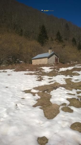

Prepare your backpack and head to cabane de la jasse des esquers du dessous, boulevard de la griole bas, savignac-les-ormeaux, foix, ariège, occitania, francia metropolitana, 09110, francia. There you will find the Cabane de la Jasse des Esquers du Dessous refuge at 1264 meters of elevation. An essential stop along the way (Lat: 42.695, Lon: 1.785) for any mountain enthusiast.
18.3°C
Feels like: 17.1°C3.9 km/h
Gusts: 25.6 km/h4290 m
Snow lineUV 4.05
Clouds: 100% 22.53 mm
 11.5 km/h
 UV máx: 5.55
 06:16
06:16
 21:26
0.4 mm
9.1 km/h
UV máx: 7.9
06:15
21:26
0 mm
8.7 km/h
UV máx: 7.15
06:15
21:27
1.7 mm
8.6 km/h
UV máx: 7.4
06:15
21:28
4.2 mm
8.6 km/h
UV máx: 8.15
06:14
21:28
3.6 mm
6.3 km/h
UV máx: 5.95
06:14
21:29
1.2 mm
5.1 km/h
UV máx: 7.75
06:14
21:30
21:26
0.4 mm
9.1 km/h
UV máx: 7.9
06:15
21:26
0 mm
8.7 km/h
UV máx: 7.15
06:15
21:27
1.7 mm
8.6 km/h
UV máx: 7.4
06:15
21:28
4.2 mm
8.6 km/h
UV máx: 8.15
06:14
21:28
3.6 mm
6.3 km/h
UV máx: 5.95
06:14
21:29
1.2 mm
5.1 km/h
UV máx: 7.75
06:14
21:30
On the Pyrenian slope of Savignac-les-Ormeaux below the summits that raise the relief to Tute de l'Ours , Pic du Paille , Pic Baune or Pic de Belh , this coat is located in a half mountain strip that works as a transition between the valley bottom and the most open terrain of height. Its location, at 1264 meters, places it in a useful area to gain a progressive level before entering more exposed sectors, and also as a reference in itineraries that move between the valleys d'Ax and the lomas that ascend to the upper cords.
Cabane de la Jasse des Esquers du Dessous It is mainly a point of support for hiking tours along the Ariège and for long days where it is appropriate to fail the climb or to have an option of withdrawal to lower levels. The closeness of the GR 10 strengthen this role as a liaison shelter within the French Pyrenees, while local tours such as N21 Couillet de Bergon help understand that it is not an isolated area of high crest, but a place connected to the network of roads in the area. From here, the land can move quickly from forest trails or slopes to slopes more sustained according to the chosen route, so the demand depends much on the concrete route and the continuity of the route.
In planning, attention should be paid to autonomy. There are several cartographed sources in the environment, but the nearest one is about 2.5 km away, so it is not wise to have immediate water next to the shelter. In a mountain area like this, close to the area of Ax-les-Thermes and access to higher levels, time can change quickly and the coat must be understood as logistical support rather than as a guarantee of services. For routes of passage, escape or approach to nearby summits, it is more useful if you arrive with secure water, time margin and prior planning of the route of entry and exit.


📏 0 Km
⛰️ 1264 m

📏 0.8 Km
⛰️ 1700 m

📏 0.8 Km
⛰️ 1735 m

📏 1.1 Km
⛰️ 1350 m

📏 2.4 Km
⛰️ 1480 m

📏 2.5 Km
⛰️ 1460 m

📏 2.5 Km
⛰️ 1488 m

📏 2.7 Km
⛰️ 1645 m
Download the app and start looking for the shelter of your next adventure


Find a place to sleep before night falls.


