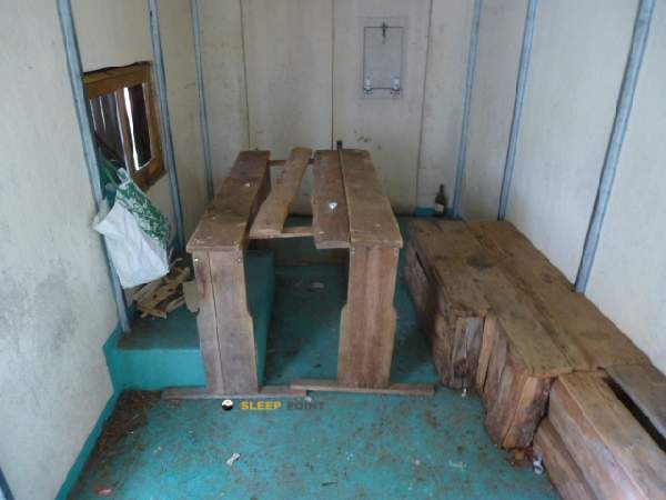
Mountain refuge Cabane de Serre
We have it listed in the app!
We have it listed in the app!


Prepare your backpack and head to route forestière du pé d'argang, perteguet, alos, saint-girons, ariège, occitania, francia metropolitana, 09200, francia. There you will find the Cabane de Serre refuge at 1347 meters of elevation. An essential stop along the way (Lat: 42.886, Lon: 1.122) for any mountain enthusiast.
9.1°C
Feels like: 8.3°C4.5 km/h
Gusts: 2.2 km/h4230 m
Snow lineUV 0
Clouds: 100% 25.3 mm
 17.6 km/h
 UV máx: 4.6
 06:18
06:18
 21:29
1.2 mm
16.4 km/h
UV máx: 7.35
06:17
21:30
2.1 mm
13.6 km/h
UV máx: 7.5
06:17
21:30
0.1 mm
9.7 km/h
UV máx: 6.9
06:17
21:31
7.2 mm
11 km/h
UV máx: 7.75
06:16
21:32
6.9 mm
7.3 km/h
UV máx: 2.8
06:16
21:32
0 mm
8.1 km/h
UV máx: 7.65
06:16
21:33
21:29
1.2 mm
16.4 km/h
UV máx: 7.35
06:17
21:30
2.1 mm
13.6 km/h
UV máx: 7.5
06:17
21:30
0.1 mm
9.7 km/h
UV máx: 6.9
06:17
21:31
7.2 mm
11 km/h
UV máx: 7.75
06:16
21:32
6.9 mm
7.3 km/h
UV máx: 2.8
06:16
21:32
0 mm
8.1 km/h
UV máx: 7.65
06:16
21:33
In the western Ariège, on the route forestière du Pé d'Argang, this coat is left in the mountain of Wings , within a sector of medium and high mountain that links forests, loops and cordals with progressive access to the Réserve Naturelle du Mont Valier . Its position places it between local and more continuous routes, with a clear role as a step point rather than an isolated destination.
The area passes through itineraries that can extend or shorten the day according to meteor, schedule or tiredness. The large circuit of the reserve and section 4 of the GR 10 help to understand its usefulness: it serves to fail a journey, solve a stage that is extended or gain margin before continuing to more open grounds. It also fits with more communal turns, such as those moving towards the Pic de la Pène or the SourRoque environment.
The Cabane de Serre , at 1347 meters, it is not left in an immediate valley bottom, so it should be considered a key to autonomy. There is a registered source about 1.47 km, reasonable but not immediate distance, and the rest of the water points appear quite more dispersed. This suggests not having safe water in the same cabin and leaving with sufficient margin, especially if used as support on a long day or on a journey.
The nearby relief, with references like Cap de Bouirech and the cordal that ascends towards higher summits like the Tic d'Eychelle it strengthens this character as a mountain shelter in the transition area: still connected with forest tracks and routes, but already useful to focus on wider and more exposed terrain. In changing conditions, it can be more practical as an intermediate coat and reorganisation point than as a basis with secured resources.


📏 0.6 Km
⛰️ 1335 m

📏 2 Km
⛰️ 1610 m

📏 2 Km
⛰️ 1612 m

📏 2.3 Km
⛰️ 1470 m

📏 2.5 Km
⛰️ 1580 m

📏 3.2 Km
⛰️ 1409 m
📏 3.4 Km
⛰️ 1418 m

📏 3.4 Km
⛰️ 1410 m
Download the app and start looking for the shelter of your next adventure


Find a place to sleep before night falls.


