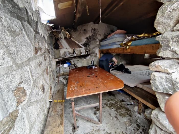
Mountain refuge Cabane de Parau
We have it listed in the app!
We have it listed in the app!


At 2000 meters above sea level, nestled in couillade de pinet, orlu, foix, ariège, occitania, francia metropolitana, 09110, francia, stands the Cabane de Parau refuge. It is the perfect stop to spend the night or catch your breath. GPS coordinates: 42.658, 1.939.
5.4°C
Feels like: 3.6°C1.5 km/h
Gusts: 6.5 km/h4490 m
Snow lineUV 0
Clouds: 100% 23.1 mm
 21.1 km/h
 UV máx: 4.4
 06:15
06:15
 21:25
1.3 mm
13.7 km/h
UV máx: 8
06:15
21:26
0 mm
12.2 km/h
UV máx: 6.65
06:15
21:26
0.5 mm
13.5 km/h
UV máx: 7.35
06:14
21:27
2.4 mm
10.1 km/h
UV máx: 8.25
06:14
21:28
0.9 mm
9.4 km/h
UV máx: 4.95
06:14
21:28
1.2 mm
7.7 km/h
UV máx: 7.9
06:14
21:29
21:25
1.3 mm
13.7 km/h
UV máx: 8
06:15
21:26
0 mm
12.2 km/h
UV máx: 6.65
06:15
21:26
0.5 mm
13.5 km/h
UV máx: 7.35
06:14
21:27
2.4 mm
10.1 km/h
UV máx: 8.25
06:14
21:28
0.9 mm
9.4 km/h
UV máx: 4.95
06:14
21:28
1.2 mm
7.7 km/h
UV máx: 7.9
06:14
21:29
The most useful thing when planning the Cabane de Parau is to understand it as a point of passage within long routes, not as a place where it is appropriate to trust without margin. Its position, in the surroundings of Orlu and the couillade of Pinet, places it close to the GR 7 and variants of the HRP , so it fits mainly in days of link between necklaces and side changes. This role of mountain shelter in the eastern sector of Ariège is more relevant than any approach to stay.
At about 2000 meters, the environment is already clearly montane and exposed to rapid variations of time. In this part of Occitania, between the valley of Orlu and the steps that connect to the Andorran border, the progression is usually marked by orientation turns and by terrain where a necklaces completely changes the feeling of the journey. Therefore, in long journeys, it is not enough to look at the distance on the map: it is necessary to foresee how the fog, wind or a day charged to the navigation between the loops and steps.
The environment reinforces this mountain character. Summits like the Pic de Mortiers , Puig de Terlers or Pic Lanoux , which draw a mineral and open cord, more useful to be placed in the relief than to present the shelter as simple access to a particular top. It also fits into routes to L'Étang d'En Beys , within a sector very frequented by those who chain stages between shelters, lakes and ports.
A conservative approach should be maintained in the logistics part. There are sources registered in the area, but the nearest one is about 2.5 km away, so it is not wise to have immediate water next to the coat. If it comes as a support in a journey, it makes more sense to get there with sufficient autonomy and to use it as a safeguard within a long day than to depend on finding specific resources or conditions there.


📏 2 Km
⛰️ 1400 m

📏 2.1 Km
⛰️ 1380 m

📏 2.2 Km
⛰️ 1421 m
📏 2.4 Km
⛰️ 2080 m

📏 2.4 Km
⛰️ 2080 m

📏 3.2 Km
⛰️ 2019 m

📏 3.3 Km
⛰️ 1792 m

📏 3.3 Km
⛰️ 1930 m
Download the app and start looking for the shelter of your next adventure


Find a place to sleep before night falls.


