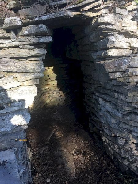
Mountain refuge Abri de la Bossière
We have it listed in the app!
We have it listed in the app!


If you are planning a route through abri de la bossière, d 31, gevrey-chambertin, beaune, côte-d'or, borgoña-franco condado, francia metropolitana, 21220, francia, the Abri de la Bossière refuge is a must-stop. Located at 300 m above sea level, it offers hikers and climbers a safe place to regain strength. Save its coordinates (47.226, 4.95) in your GPS to stay on course during your journey.
16.5°C
Feels like: 14.9°C11.8 km/h
Gusts: 30.6 km/h3900 m
Snow lineUV 0
Clouds: 100% 1.4 mm
 22.9 km/h
 UV máx: 6.6
 05:47
05:47
 21:29
8.4 mm
22.8 km/h
UV máx: 2.65
05:46
21:30
0 mm
18.1 km/h
UV máx: 5.8
05:46
21:31
1 mm
25.3 km/h
UV máx: 7.3
05:45
21:32
0 mm
11.1 km/h
UV máx: 6.7
05:45
21:33
0.6 mm
14.4 km/h
UV máx: 7.25
05:44
21:33
2.7 mm
15.1 km/h
UV máx: 7
05:44
21:34
21:29
8.4 mm
22.8 km/h
UV máx: 2.65
05:46
21:30
0 mm
18.1 km/h
UV máx: 5.8
05:46
21:31
1 mm
25.3 km/h
UV máx: 7.3
05:45
21:32
0 mm
11.1 km/h
UV máx: 6.7
05:45
21:33
0.6 mm
14.4 km/h
UV máx: 7.25
05:44
21:33
2.7 mm
15.1 km/h
UV máx: 7
05:44
21:34
The Abri de la Bossière functions as a logistical support point. It is useful to fail long days. It is located in a constant transit area. The GR 7 It crosses these sectors on their long journey south. This route connects the Vosges to the Pyrenees. The shelter offers a basic shelter in this route. It allows to pause the advance without too much deviation. It is a valuable resource for those who seek a place of night or technical rest.
There are several local hiking variants. The Sentier Felix Batier is one of the most relevant for its length. Also the Bernard Quarteaux path runs these slopes. The relief in Gevrey-Chambertin It's soft but constant. We're about 300 meters high. The forests of the Brochon define the environment. The terrain is comfortable. There are no major technical difficulties. However, the shelter serves as an escape from weather changes. It's a quick withdrawal option for walkers.
Water planning is fundamental here. The nearest source is located almost two kilometres away. Sufficient supplies should be charged before arrival. The autonomy of the mountaineer must be total. No specific internal services are detailed. The state of the interior may vary from time to time. It's a simple free shelter. It serves as a meteorological coat. Its location facilitates the link between different sectors of the valley. It is ideal for hiking experienced in half-distance voyages.


📏 2 Km
⛰️ 463 m

📏 4.6 Km
⛰️ 510 m

📏 6.5 Km
⛰️ 315 m

📏 7.1 Km
⛰️ 430 m

📏 9.5 Km
⛰️ 582 m

📏 10.9 Km
⛰️ 270 m

📏 14.1 Km
⛰️ 465 m
📏 16.7 Km
⛰️ 405 m
Download the app and start looking for the shelter of your next adventure


Find a place to sleep before night falls.


