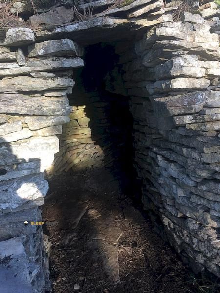
Mountain refuge Abri Roger Ratel (site gallo-romain de l'Écartelot)
We have it listed in the app!
We have it listed in the app!


Strategically located in site gallo-romain de l'ecartelot, d 18, fussey, beaune, côte-d'or, borgoña-franco condado, francia metropolitana, 21700, francia, the Abri Roger Ratel (site gallo-romain de l'Écartelot) refuge makes exploring the area easier. At 465 meters above sea level, this point of interest (47.137, 4.818) is a vital resource when planning your route.
14.7°C
Feels like: 11.9°C19.7 km/h
Gusts: 41 km/h3710 m
Snow lineUV 0
Clouds: 92% 12.5 mm
 25.8 km/h
 UV máx: 2.9
 05:47
05:47
 21:30
0.5 mm
19.7 km/h
UV máx: 5
05:46
21:31
0 mm
24.8 km/h
UV máx: 7.35
05:46
21:32
0 mm
12.6 km/h
UV máx: 6.95
05:46
21:33
5.4 mm
17.3 km/h
UV máx: 7.05
05:45
21:33
5.1 mm
17.2 km/h
UV máx: 7.05
05:45
21:34
0 mm
17.7 km/h
UV máx: 7.25
05:45
21:35
21:30
0.5 mm
19.7 km/h
UV máx: 5
05:46
21:31
0 mm
24.8 km/h
UV máx: 7.35
05:46
21:32
0 mm
12.6 km/h
UV máx: 6.95
05:46
21:33
5.4 mm
17.3 km/h
UV máx: 7.05
05:45
21:33
5.1 mm
17.2 km/h
UV máx: 7.05
05:45
21:34
0 mm
17.7 km/h
UV máx: 7.25
05:45
21:35
Plan a journey through the region of Burgundy - Franco Condado needs to understand the support points available in the half-mountain areas of CÃ te-d'Or. In the vicinity of the commune of Fussey the relief is characterized by an alternation between forest areas and transitional grounds which, although they do not present the technical difficulties of the high mountain, require a rigorous organization. This sector, deeply marked by its historical heritage, functions as a natural corridor for itineraries linking various valleys of the Beaune district.
The Abri Roger Ratel it is integrated in a functional way in the environment of the Galorroman site of l'Écartelot, offering a point of protection for those who travel through these average levels. At an altitude of 465 meters, its role is essentially that of a passage shelter, providing basic protection in an area where weather exposure can vary rapidly. Its strategic location allows to divide long days without the need to descend to the nearest urban nuclei, maintaining the continuity of the route in a moderate environment of isolation.
In terms of logistics and autonomy, it is imperative that the mountaineers consider water management the most critical factor. The nearest sources of supply are at a considerable distance, usually exceeding six kilometres in the direction of populations such as Arcenant or Bouilland . This point should therefore be treated as an emergency rest or overnight facility under a total self-sufficiency regime, always ensuring a sufficient water reserve before reaching this sector of the route.
The relevance of this enclave is consolidated by being a reference point in the drawing of the GR 7 , facilitating the transit on the long journey that connects the Vosgos to the south. It is also close to routes such as the Sentier Felix Batier allows trails to explore the network of local trails with a clear physical reference on the map. In the absence of prominent summits in the immediate environment, the activity focuses on the progression of long-distance paths and the interpretation of the historical landscape surrounding the shelter.


📏 5.6 Km
⛰️ 405 m

📏 6.5 Km
⛰️ 380 m

📏 8.7 Km
⛰️ 582 m

📏 14.1 Km
⛰️ 300 m

📏 14.9 Km
⛰️ 510 m

📏 15.5 Km
⛰️ 463 m

📏 16.4 Km
⛰️ 430 m

📏 19.9 Km
⛰️ 315 m
Download the app and start looking for the shelter of your next adventure


Find a place to sleep before night falls.


