Mountain refuge Halte Jacquaire
We have it listed in the app!
We have it listed in the app!


Protected by the wild surroundings of halte jacquaire, rue hôtel dieu, miguet, saint-lizier, saint-girons, ariège, occitania, francia metropolitana, 09190, francia, the Halte Jacquaire refuge is your best ally at 425 meters of elevation. Once you reach its coordinates (43.001, 1.138), you can enjoy a well-deserved mountain rest.
17°C
Feels like: 18.4°C1.5 km/h
Gusts: 2.2 km/h4530 m
Snow lineUV 0
Clouds: 100% 0 mm
0 mm
 13.3 km/h
 UV máx: 7.6
 06:18
06:18
 21:29
10 mm
21.9 km/h
UV máx: 0.9
06:17
21:29
0.1 mm
11.7 km/h
UV máx: 7.4
06:17
21:30
0.4 mm
23.3 km/h
UV máx: 6.85
06:17
21:31
0.15 mm
10.4 km/h
UV máx: 6.9
06:16
21:31
4.8 mm
10.7 km/h
UV máx: 5.95
06:16
21:32
1.2 mm
14.8 km/h
UV máx: 2.7
06:16
21:33
21:29
10 mm
21.9 km/h
UV máx: 0.9
06:17
21:29
0.1 mm
11.7 km/h
UV máx: 7.4
06:17
21:30
0.4 mm
23.3 km/h
UV máx: 6.85
06:17
21:31
0.15 mm
10.4 km/h
UV máx: 6.9
06:16
21:31
4.8 mm
10.7 km/h
UV máx: 5.95
06:16
21:32
1.2 mm
14.8 km/h
UV máx: 2.7
06:16
21:33
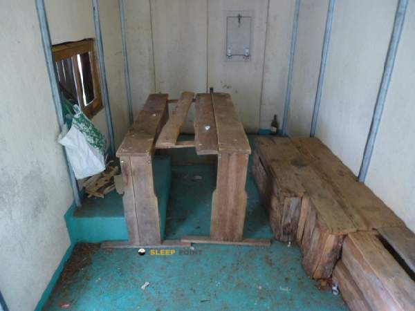
Halte Jacquaire is located in Saint-Lizier, in the sector of Saint-Girons, already at the foot of the Pyrenees mountain of Occitania and at a modest level of 425 meters. It does not respond to the model of isolated high mountain shelter, but to the model of useful support in a transition area between inhabited environment, forest lomas and first elevations that announce the pirenees relief. This position makes it practical when time changes and it is appropriate to reorganize a day without moving away from the main axis of the valley.
In its immediate environment there are several very close sources, some a few minutes on foot, a relevant detail to plan water autonomy with more margin. Even so, in mountain and half mountain it is always appropriate to confirm their real availability before they are dependent on them, especially if they are linked stages or come out with unstable meteorology.
By location, this free shelter fits well as a point of passage or support for itineraries such as the Chemin du Piémont Pyrénéen and local tours around Saint-Lizier. Rather than serving for great ascendations, its role seems to be linked to liaison days, smooth trekking of pediemonte or tours that gradually gain height towards nearby hills such as the Tuc de Montcalivert.
The demand here depends less on the altitude than on how the route is managed: variable terrain, possible changes in rhythm between urban sections, mountain roads and hillsides, and a meteorology that can complicate the orientation or lengthen the march even if the relief is not extreme. Therefore, it remains a point where basic autonomy, reading of the itinerary and forecasting of time have more weight than the limit.


📏 12.2 Km
⛰️ 1410 m
📏 12.3 Km
⛰️ 1418 m

📏 12.7 Km
⛰️ 1470 m

📏 12.9 Km
⛰️ 845 m

📏 12.9 Km
⛰️ 1347 m

📏 13.4 Km
⛰️ 1335 m

📏 13.4 Km
⛰️ 1064 m

📏 14.4 Km
⛰️ 1610 m
Download the app and start looking for the shelter of your next adventure


Find a place to sleep before night falls.


