Mountain refuge Cabane de Marterat

We have it listed in the app!


            Mountain refuge Cabane de Marterat in cabane de marterat, chemin du cable, tramesaygues, ustou, saint-girons, ariège, occitania, francia metropolitana, 09140, francia
Five orange stars in a horizontal row representing a five-star rating.

Cabane de Marterat

Lat: 42.725xxx – Lon: 1.245xxx
📍 cabane de marterat, chemin du cable, tramesaygues, ustou, saint-girons, ariège, occitania, francia metropolitana, 09140, francia
Cabane de Marterat

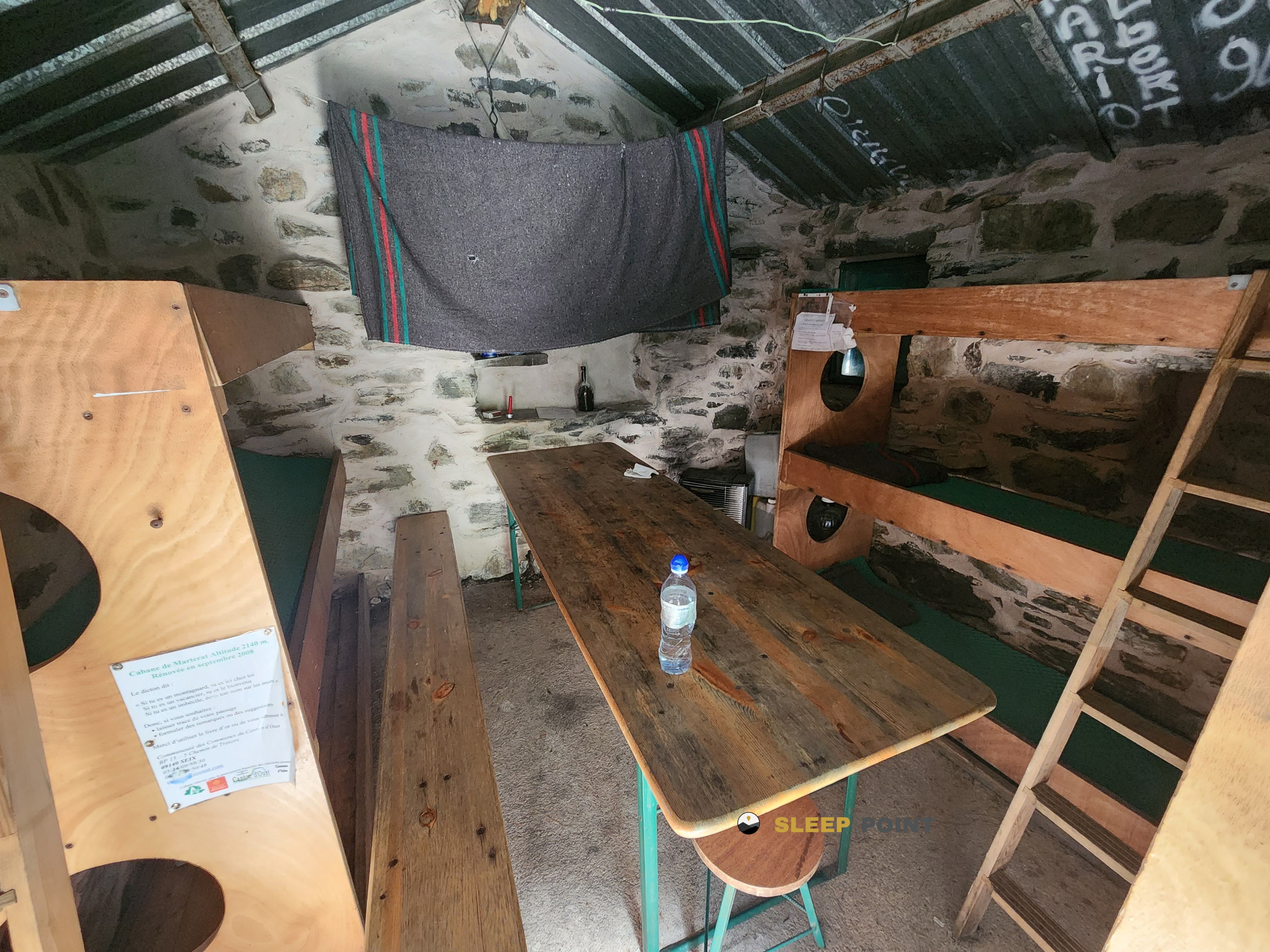
At 2139 meters above sea level, nestled in cabane de marterat, chemin du cable, tramesaygues, ustou, saint-girons, ariège, occitania, francia metropolitana, 09140, francia, stands the Cabane de Marterat refuge. It is the perfect stop to spend the night or catch your breath. GPS coordinates: 42.725, 1.245.

See more
See more
Usuario

Lucas Martinez

Premium user

Live weather: Cabane de Marterat

Before heading to Cabane de Marterat, check the weather: we currently have 4.5°C (feels like 1.7°C). With wind gusts reaching 13 km/h and a freezing level around 4430 meters, the daytime high will not exceed 11.4°C.
Temperature

4.5°C

Feels like: 1.7°C
Wind

22.7 km/h

Gusts: 13 km/h
Freezing level 0°

4430 m

Snow line
Sky & UV

UV 0

Clouds: 27%

Next 48 hours evolution

7-day forecast

04/06
11.4°
10.2 mm 25.6 km/h UV máx: 5.8
06:18 21:28
05/06
9.7° -0.3°
0.2 mm 21.8 km/h UV máx: 8
06:17 21:29
06/06
13.3° 2.9°
0.1 mm 10 km/h UV máx: 7.45
06:17 21:29
07/06
15.9°
0.2 mm 12 km/h UV máx: 6.95
06:17 21:30
08/06
19° 8.1°
2.7 mm 9.8 km/h UV máx: 8.05
06:17 21:31
09/06
9.5° 2.7°
5.7 mm 7.7 km/h UV máx: 7
06:16 21:31
10/06
16° 2.8°
1.8 mm 7.8 km/h UV máx: 7.85
06:16 21:32

As an intermediate stop on a long day, Cabane de Marterat It fits well in the high sector of Ustou, already in a clearly pirenaic environment and at 2139 meters. Its position places it in a useful strip for those who move between routes of crossing and the terrain of summits, with the passage of routes such as the HRP and Porta del Cel , in addition to access to the Port of Salau and the surroundings of the Cagateille circus. More than a shelter linked to a single valley, it works as a point of support in a liaison area, where the relief gains height quickly and the ground invites to share efforts rather than concentrate everything in a single day.

From this cabane, mountain utility is very linked to stage planning. The closeness of elevations like the Pic de Montarenyo or Tuc de Lasauguèda It strengthens its role as a basis for moving on high peaks and slopes, always within a mountain context where meteorology can change quickly. It is also a place to consider by those who cross the eastern central Pyrenees, in an area close to the Certascan area and the large cross-border routes. In practical terms it is appropriate to propose the exit with autonomy: the registered sources do not appear next to the shelter, but several kilometres away, so it is not wise to have immediate water in the environment. This combination of mountain traffic and some isolation makes it advisable to arrive with sufficient water, food and time margin.

Hiking routes from the refuge

Porta del Cel

Porta del Cel

↔ Variable distance
HRP

HRP Étape 26

↔ Variable distance
HRP

HRP Étape 27

↔ Variable distance
HRP

HRP Étape 28

↔ Variable distance
Local

route du Port de Salau

↔ Variable distance
Local

Le cirque de Cagateille

↔ Variable distance
GR T 59

Tavascan - Port de Colatx

↔ Variable distance
GR T 58

Tavascan - Coll de Tavascan

↔ Variable distance

Nearby peaks

Mont-roig

2864.4 m
Lat: 42.7107 Lon: 1.1768

Tuc de Lasauguèda

2761.5 m
Lat: 42.7179 Lon: 1.2672

Pic de Soune

2556.1 m
Lat: 42.7195 Lon: 1.2967

Certascan Nord

2839.9 m
Lat: 42.7141 Lon: 1.2781

Tuc de Montabòna

2795.2 m
Lat: 42.7187 Lon: 1.2749

Pic de Montarenyo

2618 m
Lat: 42.7278 Lon: 1.2292

Picarech

1794 m
Lat: 42.7565 Lon: 1.3033

Pic de Ventolau

2851.5 m
Lat: 42.6907 Lon: 1.1904

Nearby water fountains

Fuente

2.92 Km
Lat: 42.6907 Lon: 1.1904

Fuente

4.5 Km
Lat: 42.6907 Lon: 1.1904

Fuente

4.95 Km
Lat: 42.6907 Lon: 1.1904

Fuente

6.12 Km
Lat: 42.6907 Lon: 1.1904

Fuente

6.12 Km
Lat: 42.6907 Lon: 1.1904

Fuente

6.22 Km
Lat: 42.6907 Lon: 1.1904

Fuente

8.36 Km
Lat: 42.6907 Lon: 1.1904

Font de Llacs de Cardós

9.11 Km
Lat: 42.6907 Lon: 1.1904
FAQ

Frequently asked questions

Pregunta frecuente
At what exact altitude is the Cabane de Marterat refuge located?
The Cabane de Marterat refuge is located at an altitude of 2139 meters above sea level, in the natural surroundings of cabane de marterat, chemin du cable, tramesaygues, ustou, saint-girons, ariège, occitania, francia metropolitana, 09140, francia.
Pregunta frecuente
What are the GPS coordinates of the Cabane de Marterat refuge?
To locate the Cabane de Marterat refuge on your GPS or map, use the following coordinates: Latitude 42.725 and Longitude 1.245.
Pregunta frecuente
Is it necessary to carry a GPS to reach the Cabane de Marterat refuge?
It is always highly recommended to carry a GPS device, a route track, or a topographic map in the mountains. You can use the coordinates 42.725, 1.245 to locate this refuge precisely.
More areas

Other areas

Collaborative

Together we improve

image

Send your photos

You can upload photos of shelters and update their status so other users know if they can go there.

Get started
Get started
image

Rate the shelter

Leave your comments to rate the shelter’s condition. In the mountains, we look after each other.

Get started
Get started
image

Add new ones

Did we miss any? Publish the shelters you know so everyone can use them.

Get started
Get started
Download for free from the Apple App Store and Play Store.

Download the app and start looking for the shelter of your next adventure

Aplicación móvil para encontrar refugios de montaña donde dormir
Aplicación móvil para encontrar refugios de montaña donde dormir.
Mapa interactivo de refugios de montaña en los Pirineos dentro de la app
Mapa de refugios de montaña para senderismo y trekking en la app.
Pantalla con información de refugio de montaña con altitud capacidad y servicios
Pantalla con información de refugio de montaña con altitud capacidad y servicios.
Detalles de refugio de montaña con servicios y meteorología en aplicación móvil
Detalles de refugio de montaña con servicios y meteorología en aplicación móvil.
Aplicación para explorar refugios de montaña mediante mapa interactivo
Aplicación para explorar refugios de montaña mediante mapa interactivo.
Ficha completa de refugio de montaña con opiniones y servicios
Ficha completa de refugio de montaña con opiniones y servicios.
Información detallada de refugio en app para montañeros
Información detallada de refugio en app para montañeros.
Listado de refugios de montaña para senderismo y trekking
Listado de refugios de montaña para senderismo y trekking.
Explorar refugios de montaña desde una aplicación móvil
Explorar refugios de montaña desde una aplicación móvil.