Mountain refuge Abri des eaux chaudes

We have it listed in the app!


            Mountain refuge Abri des eaux chaudes in ancien chemin de l'estrop, le serre, prads, prads-haute-bléone, digne-les-bains, alpes de alta provenza, provenza-alpes-costa azul, francia metropolitana, 04420, francia
Five orange stars in a horizontal row representing a five-star rating.

Abri des eaux chaudes

Lat: 44.241xxx – Lon: 6.485xxx
📍 ancien chemin de l'estrop, le serre, prads, prads-haute-bléone, digne-les-bains, alpes de alta provenza, provenza-alpes-costa azul, francia metropolitana, 04420, francia
Abri des eaux chaudes

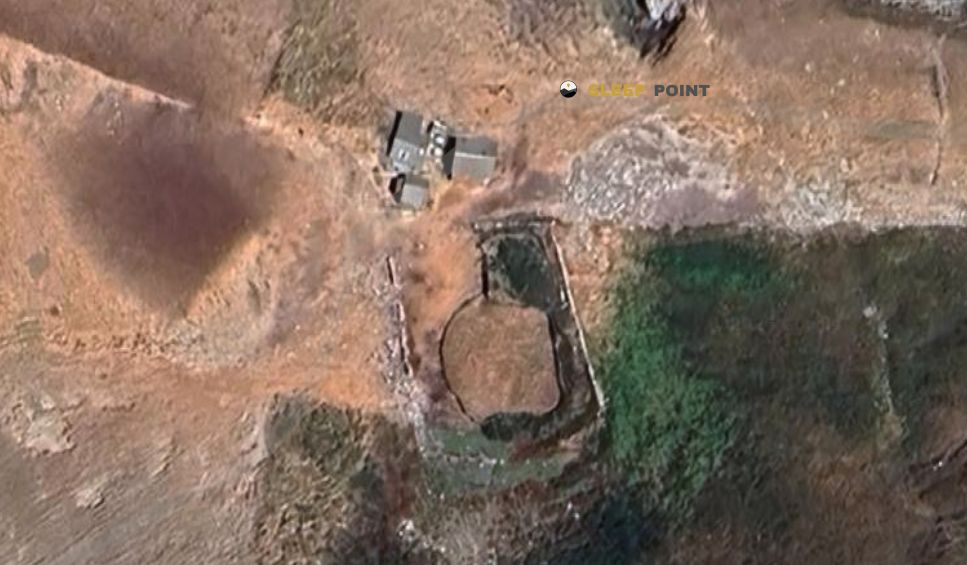
The Abri des eaux chaudes refuge stands at 1250 meters above sea level, overlooking the surroundings of ancien chemin de l'estrop, le serre, prads, prads-haute-bléone, digne-les-bains, alpes de alta provenza, provenza-alpes-costa azul, francia metropolitana, 04420, francia. It is a key spot for mountaineers looking to spend the night or take a break. Its coordinates (44.241, 6.485) place it in a strategic position for exploring the peaks and trails of the region.

See more
See more
Usuario

Lucas Martinez

Premium user

Live weather: Abri des eaux chaudes

If you plan to go up today to 1250 m at Abri des eaux chaudes, you will find 14.5°C with a feels-like temperature of 12.7°C. The freezing level is at 4030 m. The forecast shows steady winds of 0.8 km/h and peaks of 3.6 km/h. A high of 19.7°C is expected.
Temperature

14.5°C

Feels like: 12.7°C
Wind

0.8 km/h

Gusts: 3.6 km/h
Freezing level 0°

4030 m

Snow line
Sky & UV

UV 1.7

Clouds: 67%

Next 48 hours evolution

7-day forecast

04/06
19.7° 9.6°
11.9 mm 21.4 km/h UV máx: 7.25
05:52 21:13
05/06
17.4° 5.4°
1.1 mm 13.8 km/h UV máx: 7.8
05:51 21:13
06/06
18.4° 9.3°
0 mm 15.6 km/h UV máx: 7.95
05:51 21:14
07/06
19.9° 11.1°
0 mm 11.1 km/h UV máx: 6.65
05:50 21:15
08/06
22° 12.1°
0 mm 11.7 km/h UV máx: 7.95
05:50 21:15
09/06
21.7° 13.5°
0 mm 16.6 km/h UV máx: 7.5
05:50 21:16
10/06
21.9° 11.5°
0 mm 12.1 km/h UV máx: 7.65
05:50 21:17

The route of the local PR and the rise to the Estrop pass close. In the environment of Abri des eaux chaudes , these itineraries draw a land of medium and high mountain in transition, where the Bléone valley is gradually adjusted before gaining height towards the most open reliefs. The geographical reference is clear: the course of the Bléone River, which is born on the slopes of the Tête de l'Estrop, organizes the orientation and serves as a natural axis to understand the accesses. From this point of view, the progression requires reading of the ground and some continuity in the navigation, especially if it is to link with longer routes or approaches to nearby summits such as the Tête de Chabrières or the Tête de l'Estrop itself.

This coat works as basic support for mountaineers who prioritize autonomy and prudent planning. The absence of detailed information on equipment or state requires not to rely on it as the only logistical resource. The water is not immediate: the nearest source is about 3.4 km, which conditions the load from previous stages. In this context, the shelter acquires meaning as an intermediate point in long-breath tours or as a timely safeguard of time changes, rather than as a destination in itself. Its usefulness is better understood within a route strategy where valley knowledge, weather forecasting and water management make a difference.

Hiking routes from the refuge

PR

Le Bois de la Julie

↔ Variable distance
5

Trail Montée de l'Estrop

↔ 12.57 km

Nearby peaks

Tête de l'Estrop

2962 m
Lat: 44.2862 Lon: 6.5046

Puy de la Sèche

2820 m
Lat: 44.2893 Lon: 6.4843

Tête de Chabrières

2888 m
Lat: 44.281 Lon: 6.4962

La Tête Noire

2560 m
Lat: 44.2648 Lon: 6.547

Tête de l'Auriac

2639 m
Lat: 44.2785 Lon: 6.5383

Tête du Travers

1904 m
Lat: 44.2849 Lon: 6.4415

Mourre Gros

2652 m
Lat: 44.2489 Lon: 6.5404

Le Mourre de Simance

2511 m
Lat: 44.2009 Lon: 6.5329

Nearby water fountains

Fuente

3.4 Km
Lat: 44.2009 Lon: 6.5329

Fuente

6 Km
Lat: 44.2009 Lon: 6.5329

Fuente

7.96 Km
Lat: 44.2009 Lon: 6.5329

Fuente

8.53 Km
Lat: 44.2009 Lon: 6.5329

Fuente

8.56 Km
Lat: 44.2009 Lon: 6.5329

Fuente

8.65 Km
Lat: 44.2009 Lon: 6.5329

Fuente

9.68 Km
Lat: 44.2009 Lon: 6.5329
FAQ

Frequently asked questions

Pregunta frecuente
What are the GPS coordinates of the Abri des eaux chaudes refuge?
To locate the Abri des eaux chaudes refuge on your GPS or map, use the following coordinates: Latitude 44.241 and Longitude 6.485.
Pregunta frecuente
Is it necessary to carry a GPS to reach the Abri des eaux chaudes refuge?
It is always highly recommended to carry a GPS device, a route track, or a topographic map in the mountains. You can use the coordinates 44.241, 6.485 to locate this refuge precisely.
Pregunta frecuente
In which municipality or region is the Abri des eaux chaudes refuge located?
This refuge is located within the municipality of Prads-Haute-Bléone, belonging to the community or region of Provenza-Alpes-Costa Azul.
More areas

Other areas

Collaborative

Together we improve

image

Send your photos

You can upload photos of shelters and update their status so other users know if they can go there.

Get started
Get started
image

Rate the shelter

Leave your comments to rate the shelter’s condition. In the mountains, we look after each other.

Get started
Get started
image

Add new ones

Did we miss any? Publish the shelters you know so everyone can use them.

Get started
Get started
Download for free from the Apple App Store and Play Store.

Download the app and start looking for the shelter of your next adventure

Aplicación móvil para encontrar refugios de montaña donde dormir
Aplicación móvil para encontrar refugios de montaña donde dormir.
Mapa interactivo de refugios de montaña en los Pirineos dentro de la app
Mapa de refugios de montaña para senderismo y trekking en la app.
Pantalla con información de refugio de montaña con altitud capacidad y servicios
Pantalla con información de refugio de montaña con altitud capacidad y servicios.
Detalles de refugio de montaña con servicios y meteorología en aplicación móvil
Detalles de refugio de montaña con servicios y meteorología en aplicación móvil.
Aplicación para explorar refugios de montaña mediante mapa interactivo
Aplicación para explorar refugios de montaña mediante mapa interactivo.
Ficha completa de refugio de montaña con opiniones y servicios
Ficha completa de refugio de montaña con opiniones y servicios.
Información detallada de refugio en app para montañeros
Información detallada de refugio en app para montañeros.
Listado de refugios de montaña para senderismo y trekking
Listado de refugios de montaña para senderismo y trekking.
Explorar refugios de montaña desde una aplicación móvil
Explorar refugios de montaña desde una aplicación móvil.