Mountain refuge Refuge de la Gorgerette (Relais montagne de la crête de Cadun)
We have it listed in the app!
We have it listed in the app!


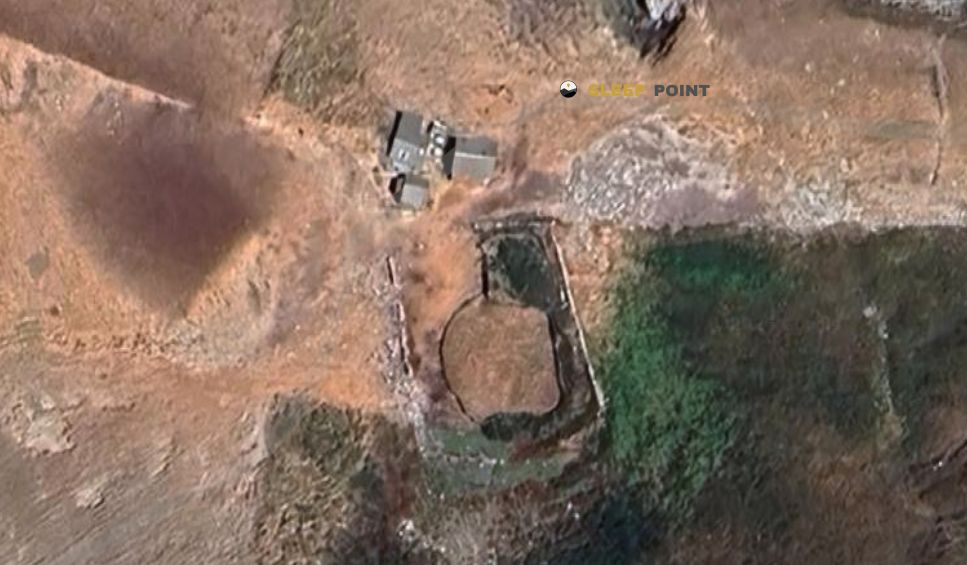
Discover the vastness of 254, chemin de la gorgerette, le serre, prads, prads-haute-bléone, digne-les-bains, alpes de alta provenza, provenza-alpes-costa azul, francia metropolitana, 04420, francia by spending the night at the Refuge de la Gorgerette (Relais montagne de la crête de Cadun) refuge. It sits at 1400 meters, offering a unique balcony over the natural landscape. Find it on the map at latitude 44.236 and longitude 6.472.
11.2°C
Feels like: 8.4°C3.7 km/h
Gusts: 11.2 km/h4210 m
Snow lineUV 0.2
Clouds: 85% 11.9 mm
 22.3 km/h
 UV máx: 6.85
 05:52
05:52
 21:13
1.1 mm
14.6 km/h
UV máx: 7.45
05:51
21:13
0 mm
15.6 km/h
UV máx: 7.95
05:51
21:14
0 mm
11.1 km/h
UV máx: 7.6
05:50
21:15
0 mm
11.7 km/h
UV máx: 7.55
05:50
21:15
0 mm
20.3 km/h
UV máx: 6.9
05:50
21:16
0 mm
13.3 km/h
UV máx: 7.65
05:50
21:17
21:13
1.1 mm
14.6 km/h
UV máx: 7.45
05:51
21:13
0 mm
15.6 km/h
UV máx: 7.95
05:51
21:14
0 mm
11.1 km/h
UV máx: 7.6
05:50
21:15
0 mm
11.7 km/h
UV máx: 7.55
05:50
21:15
0 mm
20.3 km/h
UV máx: 6.9
05:50
21:16
0 mm
13.3 km/h
UV máx: 7.65
05:50
21:17
The feeling here is more of a retreated slope than of a clear step shelter. The Refuge de la Gorgerette , also cited as the montagne relais of the crête de Cadun, is in the surroundings of Prads-Haute-Bléone, within the Alpes de Alta Provence, about 1400 meters. It is not in strict high mountain, but it is in a strip where the relief begins to close the horizon and where the weather and the orientation of the terrain already make the day quite conditioned.
Its interest is mainly in connection tours in the area of Bléone and in itineraries that seek to gain height towards the nearby massiums. In this sector they are drawn as Le Bois de la Julie the pastoral path between La Javie and Le Vernet or the itinerary from Saint-Jars to Seyne, in addition to the Montée de l'Estrop. Rather than present it as a destination in itself, it should be understood as support within a network of roads where distances can be extended according to the access chosen and where the land passes from forest and pastoral areas to a more mineral environment towards higher levels.
This reading of the landscape is well appreciated by looking at the summits of the environment: Tête de Chabrières , Puy de la Sèche , Mourre Gros or the Sommet of Valdemars rise about 5 or 6 kilometers in a straight line and mark a clearly alpine horizon. For medium mountain and mountain-experienced trails who want to organize a progressive approach to the Estrop massif, this point can make sense as an intermediate reference, not as much as a comfortable basis from which to take the logistics for granted.
That is precisely why it is necessary to plan with margin. The nearest registered source is more than 3 kilometres away, so it is not wise to have immediate water next to the shelter. It is also not appropriate to assume availability of specific support or conditions without prior verification. In an area like this, with wide relief, tracks and paths of a variable character, the map, autonomy and a conservative foresight weigh more than the apparent closeness of the toponyms.


📏 1.1 Km
⛰️ 1250 m
📏 4.2 Km
⛰️ 1909 m

📏 4.5 Km
⛰️ 1483 m

📏 4.7 Km
⛰️ 1350 m

📏 5.2 Km
⛰️ 1551 m

📏 5.7 Km
⛰️ 1565 m

📏 5.9 Km
⛰️ 1812 m

📏 5.9 Km
⛰️ 2042 m
Download the app and start looking for the shelter of your next adventure


Find a place to sleep before night falls.


