Mountain refuge Refuge Ensagents

We have it listed in the app!


            Mountain refuge Refuge Ensagents in refugi d'ensagents, coma dels llops, encamp, ad200, principado de andorra
Five orange stars in a horizontal row representing a five-star rating.

Refuge Ensagents

Lat: 42.517xxx – Lon: 1.642xxx
📍 refugi d'ensagents, coma dels llops, encamp, ad200, principado de andorra
Refuge Ensagents

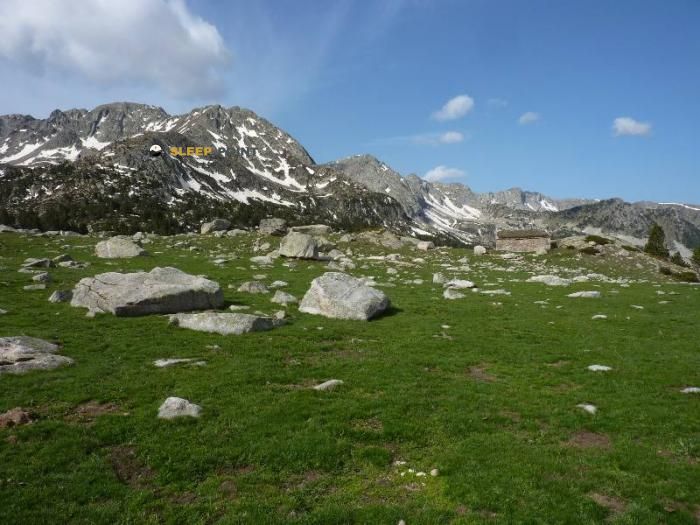
Discover the vastness of refugi d'ensagents, coma dels llops, encamp, ad200, principado de andorra by spending the night at the Refuge Ensagents refuge. It sits at 2425 meters, offering a unique balcony over the natural landscape. Find it on the map at latitude 42.517 and longitude 1.642.

See more
See more
Usuario

Lucas Martinez

Premium user

Live weather: Refuge Ensagents

If you plan to go up today to 2425 m at Refuge Ensagents, you will find 4.6°C with a feels-like temperature of 1.4°C. The freezing level is at 4300 m. The forecast shows steady winds of 14.4 km/h and peaks of 25.6 km/h. A high of 9.9°C is expected.
Temperature

4.6°C

Feels like: 1.4°C
Wind

14.4 km/h

Gusts: 25.6 km/h
Freezing level 0°

4300 m

Snow line
Sky & UV

UV 0.2

Clouds: 100%

Next 48 hours evolution

7-day forecast

04/06
9.9° 2.5°
23.3 mm 19.9 km/h UV máx: 5.2
06:17 21:26
05/06
7.2° -0.5°
0 mm 17.7 km/h UV máx: 8.15
06:17 21:26
06/06
12.7°
0.1 mm 11.2 km/h UV máx: 7
06:16 21:27
07/06
14° 3.5°
0 mm 9.2 km/h UV máx: 6.75
06:16 21:28
08/06
15.5° 5.8°
3 mm 17.6 km/h UV máx: 7.85
06:16 21:28
09/06
13.2° 5.6°
6 mm 17 km/h UV máx: 7.95
06:15 21:29
10/06
15.9° 3.6°
0 mm 8.3 km/h UV máx: 7.95
06:15 21:30

Between Encamp and the coma of Lops

In the upper part of Encamp, within the area of the coma of Lops and at 2425 meters, Refuge Ensagents appears in a clearly mountainous strip of the Andorran interior. The nearby altitude and relief place it in a high mountain terrain where time can change quickly and where the main reference is not so much a inhabited core as the relationship between slopes, loins and steps of height. It also helps to understand its position the context of the Land of Concordia, between the sectors that link the Cortals and the high headers of eastern Andorra.

Because of this geographical setting, it is especially useful for those who make long walking days, walkways or links between valleys, rather than for a short local exit. In their surroundings they pass routes of continuity such as GR 7 , HRP and the return of the GRP La volta a Andorra , so it can function as a support for several days or as an intermediate point when crossing this sector of the country. This transit of routes does not eliminate the sense of isolation: it remains a high, exposed and logical location of mountain shelter, not of infrastructure near to road.

The next ground reinforces that profile. Cimas such as the Tosa de Llosada, Cortals, the Tosseta de Vallcivera or the Pic de la Colilla help to draw an environment of cords and rounded or stony elevations, typical of days in which the orientation and reading of the relief count. Rather than present as a basis for a single ascension, it fits better as a support to move between hills and divisives of the eastern Andorran sector.

It is appropriate to plan with autonomy. The nearest registered source is about 2.7 km away, so it is not wise to have immediate water next to the shelter. In a high area like this, and without precise data on actual availability at the point, it is reasonable to get out with enough water or confirm first where to replenish according to the chosen route.

Hiking routes from the refuge

GR 7

Des Vosges aux Pyrénées 14, Porte de Barboilliere - Portella Blanca d'Andorra

↔ Variable distance
HRP

HRP Étape 32

↔ Variable distance
CO

Camí de l'Ossa

↔ 36 km
GRP

GRP La volta a Andorra

↔ 107 km
GR 11.10

Variant Estanys de la Pera

↔ 32.1 km
HRP Var.

HRP Variante 31.1

↔ Variable distance
GR 7

GR 7 - Andorra

↔ Variable distance
Local

Ruta dels Estanys Amagats

↔ 73 km

Nearby peaks

Pic de la Colilla

2835.8 m
Lat: 42.4655 Lon: 1.6206

Tosseta de Vallcivera

2852 m
Lat: 42.4748 Lon: 1.6624

Tosa de Llosada

2560 m
Lat: 42.5487 Lon: 1.6463

Cortals

2502 m
Lat: 42.5428 Lon: 1.6617

Tosa de Espiolets

2467 m
Lat: 42.5546 Lon: 1.6536

La Mugueta

2773.0 m
Lat: 42.4759 Lon: 1.6682

Tossal de la Muga

2860 m
Lat: 42.4748 Lon: 1.6776

Alt del Griu

2875 m
Lat: 42.5254 Lon: 1.6511

Nearby water fountains

Fuente

2.73 Km
Lat: 42.5254 Lon: 1.6511

Fuente

3.81 Km
Lat: 42.5254 Lon: 1.6511

Fuente

3.84 Km
Lat: 42.5254 Lon: 1.6511

Fuente

5.07 Km
Lat: 42.5254 Lon: 1.6511

Fuente

5.14 Km
Lat: 42.5254 Lon: 1.6511

Fuente

5.18 Km
Lat: 42.5254 Lon: 1.6511

Fuente

5.33 Km
Lat: 42.5254 Lon: 1.6511

Font

5.34 Km
Lat: 42.5254 Lon: 1.6511
FAQ

Frequently asked questions

Pregunta frecuente
Are there other mountain refuges near Refuge Ensagents?
Yes, nearby you can find other options to spend the night or take shelter. El refugio más próximo es el Refuge Illa, que se encuentra a aproximadamente 2.7 km de distancia.
Pregunta frecuente
At what exact altitude is the Refuge Ensagents refuge located?
The Refuge Ensagents refuge is located at an altitude of 2425 meters above sea level, in the natural surroundings of refugi d'ensagents, coma dels llops, encamp, ad200, principado de andorra.
Pregunta frecuente
What are the GPS coordinates of the Refuge Ensagents refuge?
To locate the Refuge Ensagents refuge on your GPS or map, use the following coordinates: Latitude 42.517 and Longitude 1.642.
More areas

Other areas

Collaborative

Together we improve

image

Send your photos

You can upload photos of shelters and update their status so other users know if they can go there.

Get started
Get started
image

Rate the shelter

Leave your comments to rate the shelter’s condition. In the mountains, we look after each other.

Get started
Get started
image

Add new ones

Did we miss any? Publish the shelters you know so everyone can use them.

Get started
Get started
Download for free from the Apple App Store and Play Store.

Download the app and start looking for the shelter of your next adventure

Aplicación móvil para encontrar refugios de montaña donde dormir
Aplicación móvil para encontrar refugios de montaña donde dormir.
Mapa interactivo de refugios de montaña en los Pirineos dentro de la app
Mapa de refugios de montaña para senderismo y trekking en la app.
Pantalla con información de refugio de montaña con altitud capacidad y servicios
Pantalla con información de refugio de montaña con altitud capacidad y servicios.
Detalles de refugio de montaña con servicios y meteorología en aplicación móvil
Detalles de refugio de montaña con servicios y meteorología en aplicación móvil.
Aplicación para explorar refugios de montaña mediante mapa interactivo
Aplicación para explorar refugios de montaña mediante mapa interactivo.
Ficha completa de refugio de montaña con opiniones y servicios
Ficha completa de refugio de montaña con opiniones y servicios.
Información detallada de refugio en app para montañeros
Información detallada de refugio en app para montañeros.
Listado de refugios de montaña para senderismo y trekking
Listado de refugios de montaña para senderismo y trekking.
Explorar refugios de montaña desde una aplicación móvil
Explorar refugios de montaña desde una aplicación móvil.