Mountain refuge Refuge de la Grande Goutte

We have it listed in the app!


            Mountain refuge Refuge de la Grande Goutte in grande goutte, d 214, steige, sélestat-erstein, bajo-rin, gran este, francia metropolitana, 67420, francia
Five orange stars in a horizontal row representing a five-star rating.

Refuge de la Grande Goutte

Lat: 48.375xxx – Lon: 7.244xxx
📍 grande goutte, d 214, steige, sélestat-erstein, bajo-rin, gran este, francia metropolitana, 67420, francia
Refuge de la Grande Goutte

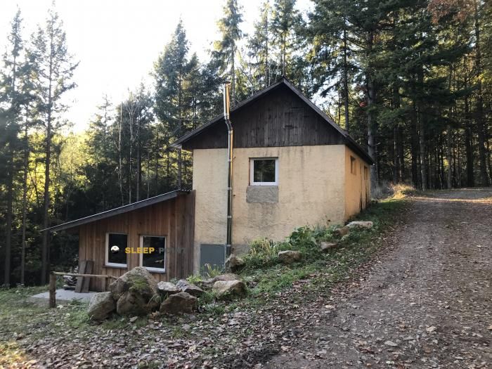
Protected by the wild surroundings of grande goutte, d 214, steige, sélestat-erstein, bajo-rin, gran este, francia metropolitana, 67420, francia, the Refuge de la Grande Goutte refuge is your best ally at 710 meters of elevation. Once you reach its coordinates (48.375, 7.244), you can enjoy a well-deserved mountain rest.

See more
See more
Usuario

Lucas Martinez

Premium user

Live weather: Refuge de la Grande Goutte

With 99% cloud coverage, the Refuge de la Grande Goutte shelter reports 13.4°C and a feels-like temperature of 9.9°C. Breeze at 20 km/h with possible gusts of 38.2 km/h. The freezing altitude is at 3200 m and the maximum will reach 16.5°C.
Temperature

13.4°C

Feels like: 9.9°C
Wind

20 km/h

Gusts: 38.2 km/h
Freezing level 0°

3200 m

Snow line
Sky & UV

UV 0

Clouds: 99%

Next 48 hours evolution

7-day forecast

04/06
16.5° 11.3°
3 mm 24.1 km/h UV máx: 3.65
05:32 21:26
05/06
14.9° 9.3°
0.3 mm 21.5 km/h UV máx: 6.7
05:31 21:27
06/06
18.9° 10°
0.6 mm 13.7 km/h UV máx: 6.7
05:31 21:28
07/06
19° 11.4°
0 mm 17.7 km/h UV máx: 6.65
05:30 21:28
08/06
21.6° 10.2°
1.05 mm 18.9 km/h UV máx: 6.3
05:30 21:29
09/06
15.7° 9.2°
9.3 mm 20 km/h UV máx: 5.85
05:30 21:30
10/06
18.9° 6.8°
0 mm 9.3 km/h UV máx: 6.75
05:29 21:31

In the central Vosges, close to Steige This free shelter is 710 meters away.

Its position fits well in the half forest mountain that links slopes, hills and rounded summits of the sector. It remains in a useful area to orient between different cords of the massif and to move towards nearby references such as Champ du Fou or the environment of Roffling , closer. It is not a site of high mountain pirenaica or alpine, but it is a valid point of support in the field where meteorology can change quickly, especially with fog, rain or wind in the high parts.

In the key to the journey, your interest is in the connection with long-distance signposted routes. The closeness of the GR 5 , along with trace as the GR 532 or GR 531 it makes it a practical reference to divide days or solve an intermediate stage within a longer route by the Vosgos. It can also serve as a basis for local circular tours, although the real utility will depend on the chosen route and the ability to link tracks, trails and crest with good visibility.

This shelter should be planned with a logic of autonomy. The nearest registered source is almost 3 kilometres away, so it is not reasonable to have immediate water next to the building. In wet or cold days, this distance can make the use of the shelter quite conditional as a simple stop or as a stage end. It is also recommended to carry reliable mapping or track, because in forest massiums like this the orientation is complicated when the time is closed.

By location and network of roads, it works better as a point of passage than as an isolated destination. Its role is mainly logistical: to offer shelter in a traffic zone where the relief is not extreme, but it is wide enough and changing to demand foresight, safe water and margin in the face of time changes.

Hiking routes from the refuge

GR 5

GR 5 Vosges, Le Donon - Ballon d'Alsace

↔ Variable distance
GR 532

GR 532

↔ 503 km
Local

Sentier des Ducs

↔ Variable distance
GR 531

GR 531

↔ 376 km
Local

Promenade Circulaire, Avec Sentier Botanique

↔ 5.8 km
Local

Circuit de Rombach-le-Franc

↔ Variable distance
Local

Circuit du col de Fouchy

↔ Variable distance
Local

Sentier de découverte

↔ Variable distance

Nearby peaks

Champ du Feu

1099 m
Lat: 48.3944 Lon: 7.269

Mt. Climont

965 m
Lat: 48.3449 Lon: 7.1833

Roffling

856 m
Lat: 48.3718 Lon: 7.254

La Grande Bellevue

858 m
Lat: 48.3835 Lon: 7.3109

Buchbuckel

852 m
Lat: 48.3877 Lon: 7.3114

Zundelkopf

882 m
Lat: 48.3963 Lon: 7.2917

Le Mont

798 m
Lat: 48.3432 Lon: 7.2072

Le Remchy

555 m
Lat: 48.327 Lon: 7.2349

Nearby water fountains

Fuente

2.92 Km
Lat: 48.327 Lon: 7.2349

Fuente

3.98 Km
Lat: 48.327 Lon: 7.2349

Fontaine du diable

4.76 Km
Lat: 48.327 Lon: 7.2349

Fuente

4.84 Km
Lat: 48.327 Lon: 7.2349

Fuente

5.19 Km
Lat: 48.327 Lon: 7.2349

Fuente

5.66 Km
Lat: 48.327 Lon: 7.2349

Fuente

7.23 Km
Lat: 48.327 Lon: 7.2349

Fuente

9.04 Km
Lat: 48.327 Lon: 7.2349
FAQ

Frequently asked questions

Pregunta frecuente
At what exact altitude is the Refuge de la Grande Goutte refuge located?
The Refuge de la Grande Goutte refuge is located at an altitude of 710 meters above sea level, in the natural surroundings of grande goutte, d 214, steige, sélestat-erstein, bajo-rin, gran este, francia metropolitana, 67420, francia.
Pregunta frecuente
What are the GPS coordinates of the Refuge de la Grande Goutte refuge?
To locate the Refuge de la Grande Goutte refuge on your GPS or map, use the following coordinates: Latitude 48.375 and Longitude 7.244.
Pregunta frecuente
Is it necessary to carry a GPS to reach the Refuge de la Grande Goutte refuge?
It is always highly recommended to carry a GPS device, a route track, or a topographic map in the mountains. You can use the coordinates 48.375, 7.244 to locate this refuge precisely.
More areas

Other areas

Collaborative

Together we improve

image

Send your photos

You can upload photos of shelters and update their status so other users know if they can go there.

Get started
Get started
image

Rate the shelter

Leave your comments to rate the shelter’s condition. In the mountains, we look after each other.

Get started
Get started
image

Add new ones

Did we miss any? Publish the shelters you know so everyone can use them.

Get started
Get started
Download for free from the Apple App Store and Play Store.

Download the app and start looking for the shelter of your next adventure

Aplicación móvil para encontrar refugios de montaña donde dormir
Aplicación móvil para encontrar refugios de montaña donde dormir.
Mapa interactivo de refugios de montaña en los Pirineos dentro de la app
Mapa de refugios de montaña para senderismo y trekking en la app.
Pantalla con información de refugio de montaña con altitud capacidad y servicios
Pantalla con información de refugio de montaña con altitud capacidad y servicios.
Detalles de refugio de montaña con servicios y meteorología en aplicación móvil
Detalles de refugio de montaña con servicios y meteorología en aplicación móvil.
Aplicación para explorar refugios de montaña mediante mapa interactivo
Aplicación para explorar refugios de montaña mediante mapa interactivo.
Ficha completa de refugio de montaña con opiniones y servicios
Ficha completa de refugio de montaña con opiniones y servicios.
Información detallada de refugio en app para montañeros
Información detallada de refugio en app para montañeros.
Listado de refugios de montaña para senderismo y trekking
Listado de refugios de montaña para senderismo y trekking.
Explorar refugios de montaña desde una aplicación móvil
Explorar refugios de montaña desde una aplicación móvil.