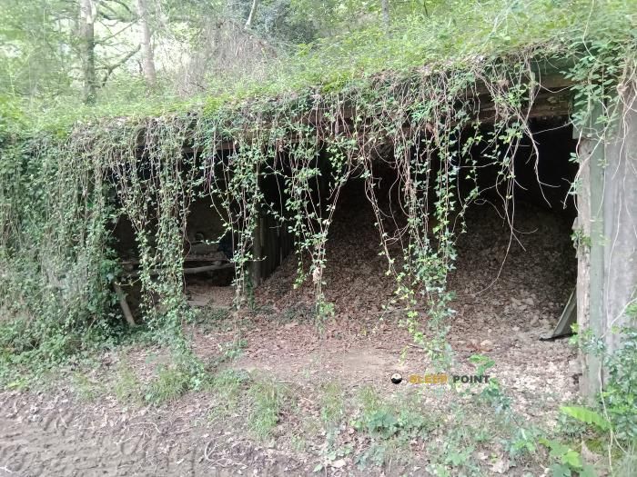
Mountain refuge Moulin d'Utziat
We have it listed in the app!
We have it listed in the app!


At 174 meters above sea level, nestled in moulin d'utziate, route de garazi, larceveau-arros-cibits, baja navarra, xaharra, larceveau, bayona, pyrénées-atlantiques, nueva aquitania, francia metropolitana, 64120, francia, stands the Moulin d'Utziat refuge. It is the perfect stop to spend the night or catch your breath. GPS coordinates: 43.22, -1.121.
17.3°C
Feels like: 17.6°C4.3 km/h
Gusts: 8.3 km/h4310 m
Snow lineUV 0
Clouds: 100% 15 mm
15 mm
 15.3 km/h
 UV máx: 1.7
 06:26
06:26
 21:39
2.5 mm
9.2 km/h
UV máx: 7.5
06:25
21:40
0.3 mm
18.4 km/h
UV máx: 5.4
06:25
21:41
0 mm
12.7 km/h
UV máx: 7.55
06:24
21:41
0.3 mm
18.7 km/h
UV máx: 3.65
06:24
21:42
3 mm
13.6 km/h
UV máx: 6.2
06:24
21:43
0 mm
16.2 km/h
UV máx: 7.35
06:24
21:43
21:39
2.5 mm
9.2 km/h
UV máx: 7.5
06:25
21:40
0.3 mm
18.4 km/h
UV máx: 5.4
06:25
21:41
0 mm
12.7 km/h
UV máx: 7.55
06:24
21:41
0.3 mm
18.7 km/h
UV máx: 3.65
06:24
21:42
3 mm
13.6 km/h
UV máx: 6.2
06:24
21:43
0 mm
16.2 km/h
UV máx: 7.35
06:24
21:43
Before you count on Moulin d'Utziat in planning, it should be considered as a basic support and not as a shelter with known services. It is in the surroundings of Larceveau, in the Lower French Navarre, just 174 meters of altitude, so it does not respond to the pattern of high mountain coat but to the point of passage in a relief of hills, forest lomas and small cords that announce the Piedemonte pirenaico. In this sector the landscape changes more by the succession of valleys, traditional roads and rounded mountains than by the presence of alpine land. Cimas close as Eheta o Munhogaïna help to read that character: modest elevations, but sufficient to channel itineraries with continuous changes in orientation and terrain.
Its practical interest appears mainly in relation it to long-distance routes that cross the area, especially the Chemin navarrais / Nafar bidea and Voie de la Nive / Errobiko bidea . Rather than serving as a basis for ascension, this point can fit into liaison days, walking tours or tours that seek to divide stages in the Basque-French pediemonte. The immediate presence of a source next to the site is a useful data for the logistics, although in mountain and half mountain it is always necessary to verify its real state before it depends on it. As there is no clear information here on internal equipment, capacity or conditions of use, it is reasonable to plan with autonomy, especially if the route continues on long roads between scattered nuclei and with changing meteorology of the Atlantic side.


📏 7.2 Km
⛰️ 258 m

📏 15.6 Km
⛰️ 793 m

📏 18.2 Km
⛰️ 1080 m

📏 19 Km
⛰️ 150 m

📏 19.1 Km
⛰️ 160 m

📏 19.3 Km
⛰️ 155 m

📏 19.4 Km
⛰️ 1168 m

📏 19.8 Km
⛰️ 1240 m
Download the app and start looking for the shelter of your next adventure


Find a place to sleep before night falls.


