Mountain refuge Abri de Babatzeko Bizbarra

We have it listed in the app!


            Mountain refuge Abri de Babatzeko Bizbarra in oihaneko bidea, baja navarra, hegiko artze gaïna, ostabat-asme, bayona, pyrénées-atlantiques, nueva aquitania, francia metropolitana, 64120, francia
Five orange stars in a horizontal row representing a five-star rating.

Abri de Babatzeko Bizbarra

Lat: 43.273xxx – Lon: -1.069xxx
📍 oihaneko bidea, baja navarra, hegiko artze gaïna, ostabat-asme, bayona, pyrénées-atlantiques, nueva aquitania, francia metropolitana, 64120, francia
Abri de Babatzeko Bizbarra

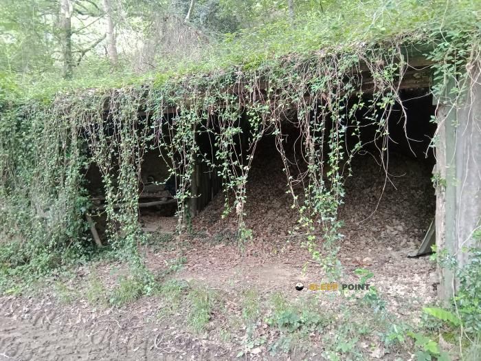
With a privileged location in oihaneko bidea, baja navarra, hegiko artze gaïna, ostabat-asme, bayona, pyrénées-atlantiques, nueva aquitania, francia metropolitana, 64120, francia, the Abri de Babatzeko Bizbarra refuge awaits you at 258 meters of altitude. Note its position (43.273, -1.069) before starting your route through the mountain range or massif.

See more
See more
Usuario

Lucas Martinez

Premium user

Live weather: Abri de Babatzeko Bizbarra

If you plan to go up today to 258 m at Abri de Babatzeko Bizbarra, you will find 17.4°C with a feels-like temperature of 16.4°C. The freezing level is at 4400 m. The forecast shows steady winds of 3.6 km/h and peaks of 8.3 km/h. A high of 17.3°C is expected.
Temperature

17.4°C

Feels like: 16.4°C
Wind

3.6 km/h

Gusts: 8.3 km/h
Freezing level 0°

4400 m

Snow line
Sky & UV

UV 0

Clouds: 54%

Next 48 hours evolution

7-day forecast

04/06
17.3° 13.4°
9.2 mm 16.8 km/h UV máx: 1.85
06:25 21:39
05/06
19.4° 10.7°
4.6 mm 9.8 km/h UV máx: 7.4
06:25 21:40
06/06
19.7° 13.1°
0 mm 28.1 km/h UV máx: 5.05
06:24 21:41
07/06
26.6° 14.5°
0 mm 14.6 km/h UV máx: 7.5
06:24 21:41
08/06
19.9° 14.7°
0.3 mm 18.7 km/h UV máx: 5.1
06:24 21:42
09/06
18.5° 12.9°
3 mm 13.6 km/h UV máx: 6.75
06:24 21:43
10/06
20.8° 10.2°
0 mm 16.2 km/h UV máx: 7.3
06:23 21:43

Soft lomas, rural roads and wavy relief define this sector of Baja Navarra in the environment of Ostabat- Asme . It is not a high mountain shelter or a point linked to alpine land. Abri de Babatzeko Bizbarra It is located on a modest level, 258 meters, within a landscape of low mountain and transition between open areas, forest and local slopes. This position fits it better in working days on broken but not extreme ground, where orientation depends more on the network of roads and rural mosaic than on great crest references.

Your practical interest is in supporting a passage area of the Basque-French interior, where tiredness, rain or a tight schedule can make a simple coat useful before continuing. The mountain access here is not understood by a strong level, but by continuity of the march, road crossings and land changes. Close summits like Bertogaine , Gaztelu Zahar u Othegaïna They help to place the next highlight, although they do not make this point a clear basis for ascension. For planning it is necessary to have basic autonomy: there are relatively close sources, with one at about 1.37 km and a drinking water point at 1.69 km, but the water should not be considered safe without checking it on the ground. In a wet area open to time changes, it is also reasonable to provide protection against rain and mud, even on short routes.

Nearby peaks

Gaztelu Zahar

361 m
Lat: 43.246 Lon: -1.0203

Arxiloko Kaskoa

400 m
Lat: 43.2706 Lon: -1.1356

Gaztelu Zahar

472 m
Lat: 43.2416 Lon: -1.1055

Othegaïna

513 m
Lat: 43.2223 Lon: -1.0603

Bertogaina

408 m
Lat: 43.2525 Lon: -1.0939

Nearby water fountains

Fuente

1.37 Km
Lat: 43.2525 Lon: -1.0939

Point d'eau potable

1.69 Km
Lat: 43.2525 Lon: -1.0939

Fuente

1.87 Km
Lat: 43.2525 Lon: -1.0939

Fuente

2.45 Km
Lat: 43.2525 Lon: -1.0939

Fuente

4.45 Km
Lat: 43.2525 Lon: -1.0939

Fuente

5.1 Km
Lat: 43.2525 Lon: -1.0939

Fuente

6.05 Km
Lat: 43.2525 Lon: -1.0939

Fuente

6.77 Km
Lat: 43.2525 Lon: -1.0939
FAQ

Frequently asked questions

Pregunta frecuente
What are the GPS coordinates of the Abri de Babatzeko Bizbarra refuge?
To locate the Abri de Babatzeko Bizbarra refuge on your GPS or map, use the following coordinates: Latitude 43.273 and Longitude -1.069.
Pregunta frecuente
Is it necessary to carry a GPS to reach the Abri de Babatzeko Bizbarra refuge?
It is always highly recommended to carry a GPS device, a route track, or a topographic map in the mountains. You can use the coordinates 43.273, -1.069 to locate this refuge precisely.
Pregunta frecuente
In which municipality or region is the Abri de Babatzeko Bizbarra refuge located?
This refuge is located within the municipality of Ostabat-Asme, belonging to the community or region of Nueva Aquitania.
More areas

Other areas

Collaborative

Together we improve

image

Send your photos

You can upload photos of shelters and update their status so other users know if they can go there.

Get started
Get started
image

Rate the shelter

Leave your comments to rate the shelter’s condition. In the mountains, we look after each other.

Get started
Get started
image

Add new ones

Did we miss any? Publish the shelters you know so everyone can use them.

Get started
Get started
Download for free from the Apple App Store and Play Store.

Download the app and start looking for the shelter of your next adventure

Aplicación móvil para encontrar refugios de montaña donde dormir
Aplicación móvil para encontrar refugios de montaña donde dormir.
Mapa interactivo de refugios de montaña en los Pirineos dentro de la app
Mapa de refugios de montaña para senderismo y trekking en la app.
Pantalla con información de refugio de montaña con altitud capacidad y servicios
Pantalla con información de refugio de montaña con altitud capacidad y servicios.
Detalles de refugio de montaña con servicios y meteorología en aplicación móvil
Detalles de refugio de montaña con servicios y meteorología en aplicación móvil.
Aplicación para explorar refugios de montaña mediante mapa interactivo
Aplicación para explorar refugios de montaña mediante mapa interactivo.
Ficha completa de refugio de montaña con opiniones y servicios
Ficha completa de refugio de montaña con opiniones y servicios.
Información detallada de refugio en app para montañeros
Información detallada de refugio en app para montañeros.
Listado de refugios de montaña para senderismo y trekking
Listado de refugios de montaña para senderismo y trekking.
Explorar refugios de montaña desde una aplicación móvil
Explorar refugios de montaña desde una aplicación móvil.