Mountain refuge Jasse de Chanteloup
We have it listed in the app!
We have it listed in the app!
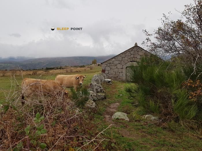

The Jasse de Chanteloup refuge stands at 1095 meters above sea level, overlooking the surroundings of route du sapet, le chambon, le pont-de-montvert, pont de montvert - sud mont lozère, florac, lozère, occitania, francia metropolitana, 48220, francia. It is a key spot for mountaineers looking to spend the night or take a break. Its coordinates (44.353, 3.74) place it in a strategic position for exploring the peaks and trails of the region.
10.7°C
Feels like: 9.1°C8 km/h
Gusts: 16.9 km/h4170 m
Snow lineUV 0
Clouds: 100% 11.2 mm
 20.5 km/h
 UV máx: 2.8
 06:02
06:02
 21:24
0 mm
17.1 km/h
UV máx: 7.45
06:02
21:25
0 mm
18.4 km/h
UV máx: 7.65
06:01
21:25
0 mm
7.7 km/h
UV máx: 6.5
06:01
21:26
0.3 mm
13.5 km/h
UV máx: 7.55
06:01
21:27
0.6 mm
17.8 km/h
UV máx: 6.7
06:00
21:27
0 mm
8.9 km/h
UV máx: 7.45
06:00
21:28
21:24
0 mm
17.1 km/h
UV máx: 7.45
06:02
21:25
0 mm
18.4 km/h
UV máx: 7.65
06:01
21:25
0 mm
7.7 km/h
UV máx: 6.5
06:01
21:26
0.3 mm
13.5 km/h
UV máx: 7.55
06:01
21:27
0.6 mm
17.8 km/h
UV máx: 6.7
06:00
21:27
0 mm
8.9 km/h
UV máx: 7.45
06:00
21:28
In this part of the Cévennes, a coat like Jasse de Chanteloup it fits mainly as intermediate support within a long day. Its position, in the surroundings of Pont de Montvert - Sud Mont Lozère and about 1095 meters, brings it closer to several passing routes that cross the area, including the GR 70 of Stevenson's Chemin and the GR 7 and GR 72 . For those who advance along these routes, it can make sense as a short detour or as a side reference in a field where it is appropriate to read the map well and understand what slope and cordal are stepped on at every moment.
The nearby relief helps to place it. The Signal du Bougès , Roc de la Fenêtre and Le Chaumadou , modest peaks at absolute altitude but sufficient to mark an open half mountain environment, with changes in exposure, wind and fog when time is closed. Rather than operating as a foot of great ascension, this shelter has an interest as a simple basis for moving between the hills, hills and roads that connect the valley with the high parts of the Mont Lozère and the nearby Bougès massif.
Mountain access does not seem isolated from road networks, but it is not appropriate to read it as an urban or comfortable point in a broad sense. The area mixes known and secondary routes, such as the Chemin de Malevrère or the path of Mas Camargues, so that the orientation becomes important if you link routes or leave the main route. This combination makes the shelter more useful to distribute stages or adjust a journey than as a destination in itself.
In logistics, there are several relatively close sources and the nearest one is less than a kilometre, although in mountain it is always necessary to provide autonomy and to confirm the water on the ground, especially in dry periods. The altitude is not extreme, but is sufficient to notice moisture, wind or fast cooling at the end of the day. This is why it is interesting to reach with margin, especially if it is used as a point of passage between the long-range trails and the rounded tops that dominate this Lozère sector.


📏 0.9 Km
⛰️ 950 m

📏 1.5 Km
⛰️ 920 m
📏 2.4 Km
⛰️ 1030 m

📏 4.4 Km
⛰️ 1190 m

📏 6.8 Km
⛰️ 1460 m

📏 8.6 Km
⛰️ 910 m

📏 8.7 Km
⛰️ 700 m

📏 8.9 Km
⛰️ 1524 m
Download the app and start looking for the shelter of your next adventure


Find a place to sleep before night falls.


