Mountain refuge Gîte d'étape les Marmottes

We have it listed in the app!


            Mountain refuge Gîte d'étape les Marmottes in gîte d'étape les marmottes, rue de la madone, saint-dalmas, valdeblore, niza, alpes marítimos, provenza-alpes-costa azul, francia metropolitana, 06420, francia
Five orange stars in a horizontal row representing a five-star rating.

Gîte d'étape les Marmottes

Lat: 44.066xxx – Lon: 7.204xxx
📍 gîte d'étape les marmottes, rue de la madone, saint-dalmas, valdeblore, niza, alpes marítimos, provenza-alpes-costa azul, francia metropolitana, 06420, francia
Gîte d'étape les Marmottes

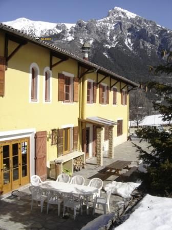
The Gîte d'étape les Marmottes refuge stands at 1300 meters above sea level, overlooking the surroundings of gîte d'étape les marmottes, rue de la madone, saint-dalmas, valdeblore, niza, alpes marítimos, provenza-alpes-costa azul, francia metropolitana, 06420, francia. It is a key spot for mountaineers looking to spend the night or take a break. Its coordinates (44.066, 7.204) place it in a strategic position for exploring the peaks and trails of the region.

See more
See more
Usuario

Lucas Martinez

Premium user

Live weather: Gîte d'étape les Marmottes

At 1300 meters, the area around Gîte d'étape les Marmottes records 12.8°C with 99% cloud cover and a UV index of 0. The temperature will peak at 19.3°C today, with winds of 5.4 km/h and a freezing level of 4250 m.
Temperature

12.8°C

Feels like: 11.5°C
Wind

5.4 km/h

Gusts: 4 km/h
Freezing level 0°

4250 m

Snow line
Sky & UV

UV 0

Clouds: 99%

Next 48 hours evolution

7-day forecast

04/06
19.3° 11.3°
5.9 mm 15.6 km/h UV máx: 7.65
05:49 21:09
05/06
18.7° 9.1°
0.5 mm 9.5 km/h UV máx: 7.5
05:49 21:10
06/06
19.7° 12.3°
0 mm 11.4 km/h UV máx: 6.9
05:48 21:10
07/06
21.4° 13.5°
0 mm 12 km/h UV máx: 7.65
05:48 21:11
08/06
22.1° 14.5°
2.7 mm 10.4 km/h UV máx: 7.9
05:48 21:12
09/06
22.4° 13.9°
0 mm 14.8 km/h UV máx: 7.05
05:48 21:12
10/06
20.7° 14.8°
1.5 mm 10.3 km/h UV máx: 3.8
05:47 21:13

Between Saint- Drums and the itineraries of the Mercantour

Gîte d'étape les Marmottes it is left in Saint-Dsos, within the municipality of Valdeblore, in the French Maritime Alps, at about 1300 meters altitude. It is located in a half-mountain strip from which one begins to gain relief towards the summits and cords surrounding the area, with the Pic de la Colmiane very close and a land that already works as before the Mercantour.

More than an isolated destination, it fits well as a point of passage to move between valleys and link hiking days in this part of Provence-Alpes@-@ Costa Azul. The closeness of the GR 52A , known as Sentier panoramique du Mercantour, it gives you interest for those who travel long routes or want to divide stages without far too far from the main axis. Local tours to places like Lac Nègre which reinforces its role in supporting one or more days of movement, rather than that of simple road accommodation.

The immediate environment combines relatively low access for alpine standards with a rapid transition to more open and exposed mountains. In this area it is appropriate to read the map well and not to be trusted by the moderate altitude of the starting point: time changes in the South Alps can affect both hills and high slopes, and the orientation of the chosen itinerary makes the day very difficult. If used as free shelter or as a cross-border support, autonomy remains important.

In logistics, water is one of the most favorable aspects here, as there are several sources very close to the building, some a few minutes on foot. Even so, it is always appropriate to check the actual availability of the mountain according to time and conditions. As no associated equipment or services are detailed, the wise thing is to propose the exit with margin, especially if the idea is to link routes, continue to higher levels or use the place as an intermediate stop within a journey.

Hiking routes from the refuge

GR 52A

Le Sentier panoramique du Mercantour

↔ 217 km
46

Lac Nègre

↔ Variable distance
32

Pointe de Clamia

↔ Variable distance
33

Chapelle Sainte-Anne

↔ Variable distance
34

Les hameaux d'Ilonse

↔ Variable distance
43

Granges de la Brasque

↔ Variable distance
44

Circuit du Tournairet

↔ Variable distance
47

Circuit du Conquet

↔ Variable distance

Nearby peaks

Mont Chalancha

2102 m
Lat: 44.0342 Lon: 7.2123

Mont Pépoiri

2674 m
Lat: 44.1105 Lon: 7.2021

Mont Viroulet

1860 m
Lat: 44.0493 Lon: 7.1732

Pic de la Colmiane

1766 m
Lat: 44.0583 Lon: 7.218

Cime du Belletz

2610 m
Lat: 44.1178 Lon: 7.2198

Pointe de Sérenton

1836 m
Lat: 44.0256 Lon: 7.1897

La Partissuollo

2051 m
Lat: 44.0307 Lon: 7.2187

Tête de Clans

2070 m
Lat: 44.0409 Lon: 7.2076

Nearby water fountains

Fuente

60 m
Lat: 44.0409 Lon: 7.2076

Fuente

95 m
Lat: 44.0409 Lon: 7.2076

Fuente

132 m
Lat: 44.0409 Lon: 7.2076

Fuente

138 m
Lat: 44.0409 Lon: 7.2076

Fuente

148 m
Lat: 44.0409 Lon: 7.2076

Fuente

161 m
Lat: 44.0409 Lon: 7.2076

Fuente

226 m
Lat: 44.0409 Lon: 7.2076

Fuente

273 m
Lat: 44.0409 Lon: 7.2076
FAQ

Frequently asked questions

Pregunta frecuente
Is it necessary to carry a GPS to reach the Gîte d'étape les Marmottes refuge?
It is always highly recommended to carry a GPS device, a route track, or a topographic map in the mountains. You can use the coordinates 44.066, 7.204 to locate this refuge precisely.
Pregunta frecuente
In which municipality or region is the Gîte d'étape les Marmottes refuge located?
This refuge is located within the municipality of Valdeblore, belonging to the community or region of Provenza-Alpes-Costa Azul.
Pregunta frecuente
Are there other mountain refuges near Gîte d'étape les Marmottes?
Yes, nearby you can find other options to spend the night or take shelter. El refugio más próximo es el Cabane Vieille - Lou Chabot DeMaria, que se encuentra a aproximadamente 4.7 km de distancia.
More areas

Other areas

Collaborative

Together we improve

image

Send your photos

You can upload photos of shelters and update their status so other users know if they can go there.

Get started
Get started
image

Rate the shelter

Leave your comments to rate the shelter’s condition. In the mountains, we look after each other.

Get started
Get started
image

Add new ones

Did we miss any? Publish the shelters you know so everyone can use them.

Get started
Get started
Download for free from the Apple App Store and Play Store.

Download the app and start looking for the shelter of your next adventure

Aplicación móvil para encontrar refugios de montaña donde dormir
Aplicación móvil para encontrar refugios de montaña donde dormir.
Mapa interactivo de refugios de montaña en los Pirineos dentro de la app
Mapa de refugios de montaña para senderismo y trekking en la app.
Pantalla con información de refugio de montaña con altitud capacidad y servicios
Pantalla con información de refugio de montaña con altitud capacidad y servicios.
Detalles de refugio de montaña con servicios y meteorología en aplicación móvil
Detalles de refugio de montaña con servicios y meteorología en aplicación móvil.
Aplicación para explorar refugios de montaña mediante mapa interactivo
Aplicación para explorar refugios de montaña mediante mapa interactivo.
Ficha completa de refugio de montaña con opiniones y servicios
Ficha completa de refugio de montaña con opiniones y servicios.
Información detallada de refugio en app para montañeros
Información detallada de refugio en app para montañeros.
Listado de refugios de montaña para senderismo y trekking
Listado de refugios de montaña para senderismo y trekking.
Explorar refugios de montaña desde una aplicación móvil
Explorar refugios de montaña desde una aplicación móvil.