Mountain refuge Fusshornbiwak

We have it listed in the app!


            Mountain refuge Fusshornbiwak in fusshorn-biwak, hängebrücke belalp-riederalp, naters, brig, vallés, 3987, suiza
Five orange stars in a horizontal row representing a five-star rating.

Fusshornbiwak

Lat: 46.418xxx – Lon: 8.009xxx
📍 fusshorn-biwak, hängebrücke belalp-riederalp, naters, brig, vallés, 3987, suiza
Fusshornbiwak

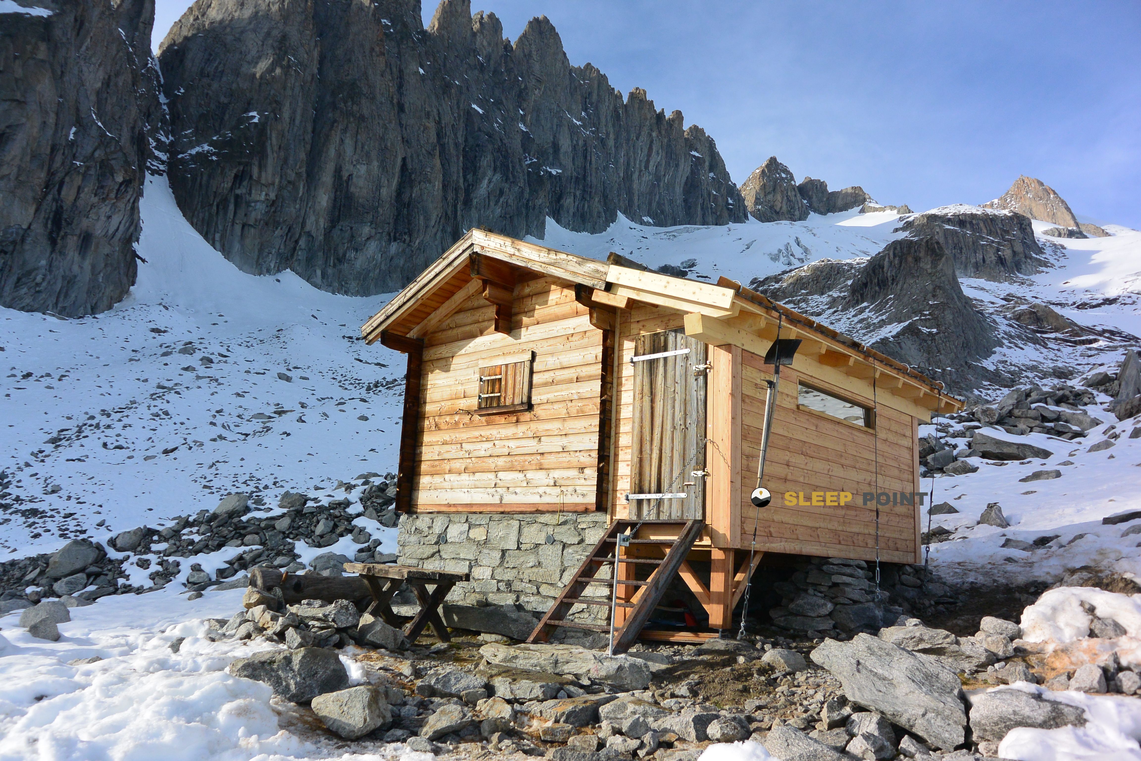
With a privileged location in fusshorn-biwak, hängebrücke belalp-riederalp, naters, brig, vallés, 3987, suiza, the Fusshornbiwak refuge awaits you at 2780 meters of altitude. Note its position (46.418, 8.009) before starting your route through the mountain range or massif.

See more
See more
Usuario

Lucas Martinez

Premium user

Live weather: Fusshornbiwak

Alpine weather summary for Fusshornbiwak: temperature at 2.3°C, feels like -2°C. Wind at 7.7 km/h with peaks of 29.5 km/h. UV index at 0 and freezing altitude at 3600 m. Maximum temperatures of 5.1°C in the coming hours.
Temperature

2.3°C

Feels like: -2°C
Wind

7.7 km/h

Gusts: 29.5 km/h
Freezing level 0°

3600 m

Snow line
Sky & UV

UV 0

Clouds: 85%

Next 48 hours evolution

7-day forecast

04/06
5.1° 0.1°
8.7 mm 17.9 km/h UV máx: 5.45
05:37 21:15
05/06
2.5° -2.4°
1.1 mm 10 km/h UV máx: 6.8
05:37 21:16
06/06
7.3°
0.3 mm 12.7 km/h UV máx: 6.75
05:36 21:16
07/06
8.9° 2.3°
0 mm 9.2 km/h UV máx: 8.5
05:36 21:17
08/06
10.3° 4.5°
2.55 mm 15.5 km/h UV máx: 8.45
05:35 21:18
09/06
5.1° 0.8°
7.5 mm 15.6 km/h UV máx: 5.15
05:35 21:18
10/06
8.7° -0.2°
0 mm 11.6 km/h UV máx: 8.25
05:35 21:19

On the Naters , in the canton of Valais , this shelter is located at 2,780 meters in a clearly alpine sector, above forest levels and in a land where weather and orientation weigh much in planning. The most useful geographical reference is its proximity to the environment of Oberaletschgletscher and the great relief that closes the area of Aletschhorn inside the Berne massif on its Valencian side.

Fusshornbiwak is close to summits that explain their character. Very close the Grosses Fusshorn less than 2 km in a straight line, and also stand out Rotstock and Geisshorn in the same environment of abrupt ridges and slopes. More to the north the Aletschhorn , a mountain of 4,195 m that gives scale to the whole. There are no specific route data associated with the shelter, so it is appropriate to understand it more as basic support on mountain ground than as a point linked to a specific signposted route.

This lack of detailed information on access and tours requires you to read the map well before you leave. In such an area, the main utility of a free or unsaved vivac is often to divide a long day, to serve as a guard on a journey or to approach an ascension, but it is not here to set links or times without clear basis. The altitude, proximity of glacier peaks and relative isolation point to a more mountainous than hiker use.

For logistics, there is a cartographed source about 1.39 km, reasonable distance on paper but that in mountain does not guarantee easy access or useful flow according to the time. Therefore, when it comes to a night or a journey through this point, it is prudent to have water autonomy and to check recent conditions. It is also appropriate not to give for alleged equipment, inner capacity or state of the shelter if no current verification is available.

As a reference for road planning, this mountain shelter fits mainly on routes where it is important to gain position on the Oberaletsch slope and move near the axis formed by Fusshorn, Rotstock and the mountains that link to the Aletsch sector. More than a destination in itself, it works as a support piece in a field where each decision depends on the relief, the present snow and the visibility.

Nearby peaks

Aletschhorn

4195 m
Lat: 46.4652 Lon: 7.9932

Riederhorn

2230 m
Lat: 46.3713 Lon: 8.0159

Bettmergrat

2871 m
Lat: 46.4179 Lon: 8.0826

Geisshorn

3740 m
Lat: 46.441 Lon: 8.0056

Rotstock

3699 m
Lat: 46.4354 Lon: 8.0014

Grosses Fusshorn

3627 m
Lat: 46.4308 Lon: 7.9978

Vorderes Geisshorn

3634 m
Lat: 46.4516 Lon: 8.001

Unterbächhorn

3554 m
Lat: 46.4057 Lon: 7.9394

Nearby water fountains

Fuente

1.39 Km
Lat: 46.4057 Lon: 7.9394

Fuente

4.05 Km
Lat: 46.4057 Lon: 7.9394

Fuente

4.27 Km
Lat: 46.4057 Lon: 7.9394

Fuente

4.29 Km
Lat: 46.4057 Lon: 7.9394

Fuente

4.35 Km
Lat: 46.4057 Lon: 7.9394

Fuente

4.37 Km
Lat: 46.4057 Lon: 7.9394

Fuente

4.56 Km
Lat: 46.4057 Lon: 7.9394

Fuente

4.68 Km
Lat: 46.4057 Lon: 7.9394
FAQ

Frequently asked questions

Pregunta frecuente
At what exact altitude is the Fusshornbiwak refuge located?
The Fusshornbiwak refuge is located at an altitude of 2780 meters above sea level, in the natural surroundings of fusshorn-biwak, hängebrücke belalp-riederalp, naters, brig, vallés, 3987, suiza.
Pregunta frecuente
What are the GPS coordinates of the Fusshornbiwak refuge?
To locate the Fusshornbiwak refuge on your GPS or map, use the following coordinates: Latitude 46.418 and Longitude 8.009.
Pregunta frecuente
Is it necessary to carry a GPS to reach the Fusshornbiwak refuge?
It is always highly recommended to carry a GPS device, a route track, or a topographic map in the mountains. You can use the coordinates 46.418, 8.009 to locate this refuge precisely.
More areas

Other areas

Collaborative

Together we improve

image

Send your photos

You can upload photos of shelters and update their status so other users know if they can go there.

Get started
Get started
image

Rate the shelter

Leave your comments to rate the shelter’s condition. In the mountains, we look after each other.

Get started
Get started
image

Add new ones

Did we miss any? Publish the shelters you know so everyone can use them.

Get started
Get started
Download for free from the Apple App Store and Play Store.

Download the app and start looking for the shelter of your next adventure

Aplicación móvil para encontrar refugios de montaña donde dormir
Aplicación móvil para encontrar refugios de montaña donde dormir.
Mapa interactivo de refugios de montaña en los Pirineos dentro de la app
Mapa de refugios de montaña para senderismo y trekking en la app.
Pantalla con información de refugio de montaña con altitud capacidad y servicios
Pantalla con información de refugio de montaña con altitud capacidad y servicios.
Detalles de refugio de montaña con servicios y meteorología en aplicación móvil
Detalles de refugio de montaña con servicios y meteorología en aplicación móvil.
Aplicación para explorar refugios de montaña mediante mapa interactivo
Aplicación para explorar refugios de montaña mediante mapa interactivo.
Ficha completa de refugio de montaña con opiniones y servicios
Ficha completa de refugio de montaña con opiniones y servicios.
Información detallada de refugio en app para montañeros
Información detallada de refugio en app para montañeros.
Listado de refugios de montaña para senderismo y trekking
Listado de refugios de montaña para senderismo y trekking.
Explorar refugios de montaña desde una aplicación móvil
Explorar refugios de montaña desde una aplicación móvil.