Mountain refuge Ehemaliges Mittelaletschbiwak SAC

We have it listed in the app!


            Mountain refuge Ehemaliges Mittelaletschbiwak SAC in bettmeralp, Östlich raron, vallés, suiza
Five orange stars in a horizontal row representing a five-star rating.

Ehemaliges Mittelaletschbiwak SAC

Lat: 46.465xxx – Lon: 8.024xxx
📍 bettmeralp, Östlich raron, vallés, suiza
Ehemaliges Mittelaletschbiwak SAC

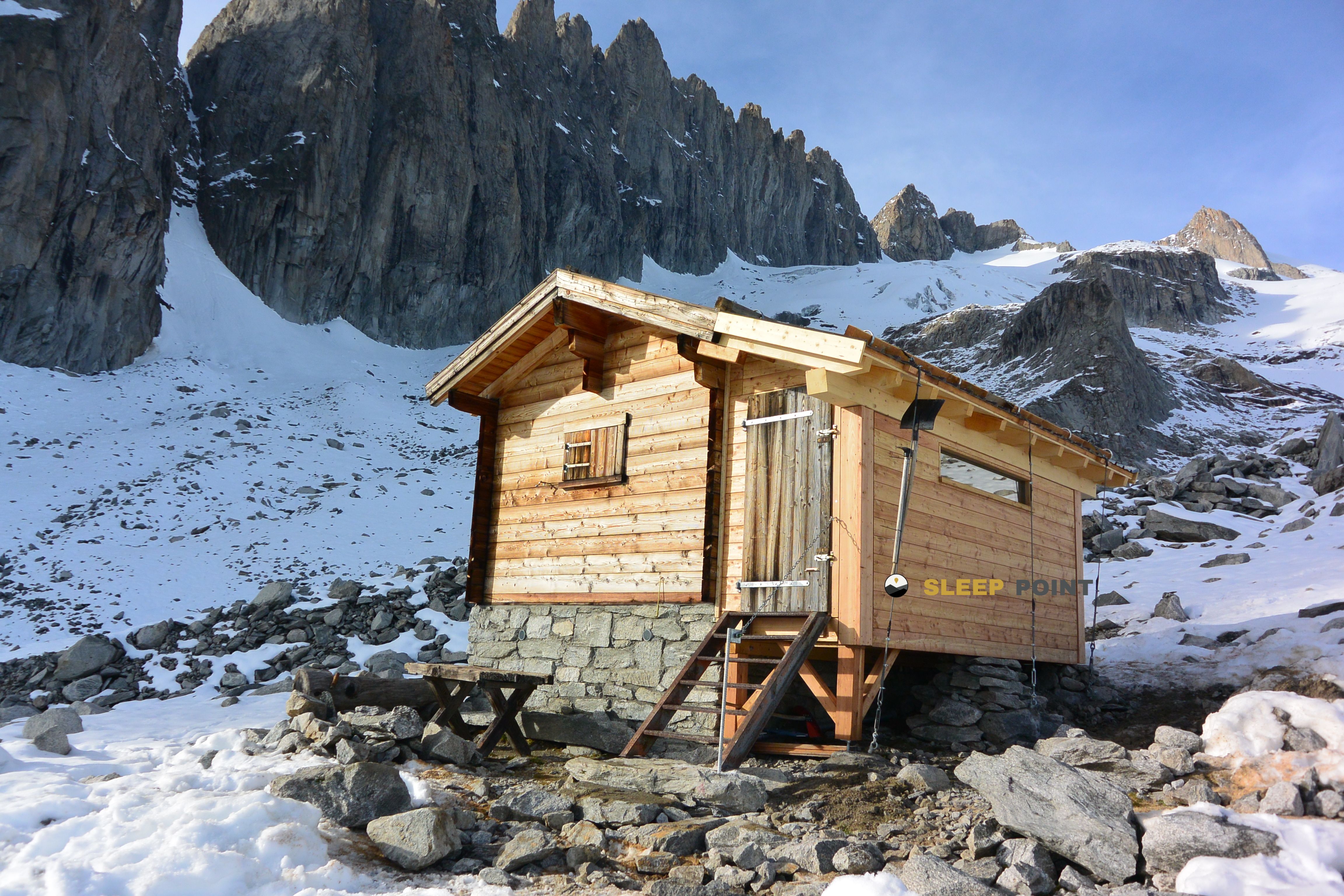
Prepare your backpack and head to bettmeralp, Östlich raron, vallés, suiza. There you will find the Ehemaliges Mittelaletschbiwak SAC refuge at 3013 meters of elevation. An essential stop along the way (Lat: 46.465, Lon: 8.024) for any mountain enthusiast.

See more
See more
Usuario

Lucas Martinez

Premium user

Live weather: Ehemaliges Mittelaletschbiwak SAC

At 3013 meters, the area around Ehemaliges Mittelaletschbiwak SAC records 1.5°C with 100% cloud cover and a UV index of 0. The temperature will peak at 2.3°C today, with winds of 6.3 km/h and a freezing level of 3730 m.
Temperature

1.5°C

Feels like: -2.9°C
Wind

6.3 km/h

Gusts: 31 km/h
Freezing level 0°

3730 m

Snow line
Sky & UV

UV 0

Clouds: 100%

Next 48 hours evolution

7-day forecast

04/06
2.3° -0.7°
11.3 mm 19.2 km/h UV máx: 5.2
05:37 21:15
05/06
0.1° -4°
1.2 mm 13.8 km/h UV máx: 7.4
05:36 21:16
06/06
3.9° 0.3°
1.6 mm 17.9 km/h UV máx: 7.6
05:36 21:16
07/06
4.9° -0.2°
0 mm 8.2 km/h UV máx: 8.5
05:36 21:17
08/06
6.6° 2.4°
2.7 mm 13.8 km/h UV máx: 7.25
05:35 21:18
09/06
3.6° -0.8°
7.5 mm 15.6 km/h UV máx: 4.85
05:35 21:18
10/06
7.2° -1.8°
0 mm 11.6 km/h UV máx: 8.25
05:35 21:19

Above Bettmeralp, already high mountain, this old vivac moves in a clearly glacial and alpine scenario. At 3013 meters, the Ehemaliges Mittelaletschbiwak SAC it fits better as a step support than as a shelter linked to comfortable access: the altitude, relief and proximity of large summits mark a serious ground, exposed to rapid changes of time and to a reserved approach to hikers used to move in height.

Its position is related to the Aletsch sector, within the great Jungfrauz-Aletschhorn group, where the glacier and the edges dominate the direction of the route. In this context, it can make sense within a journey or as an intermediate point for linking mountain itineraries that connect with the Oberaletschhütten environment, the glacial edge or the Fusshornbiwak. More than an isolated destination, it works as a piece of continuity in long days.

It also remains close to tops that well define the character of the place, such as Dreieckhorn And, something further, Aletschhorn . This proximity does not automatically turn the shelter into a basis of simple ascension; on the contrary, it suggests an environment of alpinism and demanding terrain, where orientation, the state of snow or ice and previous experience weigh more than the distance in a straight line.

It is appropriate to plan with autonomy. The registered sources are far away, more than 6 kilometres away, so it is not wise to have water near the shelter. In such an area, logistics matters as much as the route: water secured before the rise, margin to the weather and prior verification of the itinerary are basic aspects to use this point with mountain criteria.

Hiking routes from the refuge

39

Aletsch Panoramaweg

↔ 30 km
Local

Oberaletschhütten - Oberaletschgletscher

↔ Variable distance
Local

Punkt 2228 - Driest, Gletscherrand

↔ Variable distance
Local

Punkt 2586 - Fusshornbiwak

↔ Variable distance
Local

Z'Leng Fäsch - Fusshornbiwak

↔ Variable distance
Local

Hotel Belalp - Oberaletschhütten

↔ Variable distance
Local

Fiescheralp - Eggishorn

↔ Variable distance
Local

Laxeralp - Elselicka

↔ Variable distance

Nearby peaks

Aletschhorn

4195 m
Lat: 46.4652 Lon: 7.9932

Geisshorn

3740 m
Lat: 46.441 Lon: 8.0056

Dreieckhorn

3811 m
Lat: 46.4779 Lon: 8.0202

Sattelhorn

3744 m
Lat: 46.4676 Lon: 7.9643

Kleines Aletschhorn

3755 m
Lat: 46.4675 Lon: 7.9765

Rotstock

3699 m
Lat: 46.4354 Lon: 8.0014

Grosses Fusshorn

3627 m
Lat: 46.4308 Lon: 7.9978

Vorderes Geisshorn

3634 m
Lat: 46.4516 Lon: 8.001

Nearby water fountains

Fuente

6.43 Km
Lat: 46.4516 Lon: 8.001

Fuente

6.57 Km
Lat: 46.4516 Lon: 8.001

Fuente

8.37 Km
Lat: 46.4516 Lon: 8.001

Fuente

8.45 Km
Lat: 46.4516 Lon: 8.001

Fuente

9.19 Km
Lat: 46.4516 Lon: 8.001

Fuente

9.19 Km
Lat: 46.4516 Lon: 8.001

Fuente

9.34 Km
Lat: 46.4516 Lon: 8.001

Fuente

9.43 Km
Lat: 46.4516 Lon: 8.001
FAQ

Frequently asked questions

Pregunta frecuente
In which municipality or region is the Ehemaliges Mittelaletschbiwak SAC refuge located?
This refuge is located within the municipality of Bettmeralp, belonging to the community or region of Vallés.
Pregunta frecuente
Are there other mountain refuges near Ehemaliges Mittelaletschbiwak SAC?
Yes, nearby you can find other options to spend the night or take shelter. El refugio más próximo es el Konkordiahütte, que se encuentra a aproximadamente 4.6 km de distancia.
Pregunta frecuente
At what exact altitude is the Ehemaliges Mittelaletschbiwak SAC refuge located?
The Ehemaliges Mittelaletschbiwak SAC refuge is located at an altitude of 3013 meters above sea level, in the natural surroundings of bettmeralp, Östlich raron, vallés, suiza.
More areas

Other areas

Collaborative

Together we improve

image

Send your photos

You can upload photos of shelters and update their status so other users know if they can go there.

Get started
Get started
image

Rate the shelter

Leave your comments to rate the shelter’s condition. In the mountains, we look after each other.

Get started
Get started
image

Add new ones

Did we miss any? Publish the shelters you know so everyone can use them.

Get started
Get started
Download for free from the Apple App Store and Play Store.

Download the app and start looking for the shelter of your next adventure

Aplicación móvil para encontrar refugios de montaña donde dormir
Aplicación móvil para encontrar refugios de montaña donde dormir.
Mapa interactivo de refugios de montaña en los Pirineos dentro de la app
Mapa de refugios de montaña para senderismo y trekking en la app.
Pantalla con información de refugio de montaña con altitud capacidad y servicios
Pantalla con información de refugio de montaña con altitud capacidad y servicios.
Detalles de refugio de montaña con servicios y meteorología en aplicación móvil
Detalles de refugio de montaña con servicios y meteorología en aplicación móvil.
Aplicación para explorar refugios de montaña mediante mapa interactivo
Aplicación para explorar refugios de montaña mediante mapa interactivo.
Ficha completa de refugio de montaña con opiniones y servicios
Ficha completa de refugio de montaña con opiniones y servicios.
Información detallada de refugio en app para montañeros
Información detallada de refugio en app para montañeros.
Listado de refugios de montaña para senderismo y trekking
Listado de refugios de montaña para senderismo y trekking.
Explorar refugios de montaña desde una aplicación móvil
Explorar refugios de montaña desde una aplicación móvil.