Mountain refuge Cabane du Pierre-Pertuis
We have it listed in the app!
We have it listed in the app!


Prepare your backpack and head to cabane montoz, 8, sentier farron, sous le mont, tavannes, arrondissement administratif du jura bernois, région administrative du jura bernois, berna, 2710, suiza. There you will find the Cabane du Pierre-Pertuis refuge at 1258 meters of elevation. An essential stop along the way (Lat: 47.208, Lon: 7.218) for any mountain enthusiast.
7.8°C
Feels like: 6°C3.9 km/h
Gusts: 21.2 km/h3700 m
Snow lineUV 0
Clouds: 94% 15 mm
15 mm
 22.1 km/h
 UV máx: 6
 05:37
05:37
 21:21
2.3 mm
13.9 km/h
UV máx: 5.7
05:36
21:22
0 mm
15.9 km/h
UV máx: 7.2
05:36
21:23
0 mm
11.9 km/h
UV máx: 6.35
05:36
21:23
3.9 mm
8.4 km/h
UV máx: 6.85
05:35
21:24
7.2 mm
16.3 km/h
UV máx: 6.15
05:35
21:25
0 mm
13.4 km/h
UV máx: 7.05
05:35
21:25
21:21
2.3 mm
13.9 km/h
UV máx: 5.7
05:36
21:22
0 mm
15.9 km/h
UV máx: 7.2
05:36
21:23
0 mm
11.9 km/h
UV máx: 6.35
05:36
21:23
3.9 mm
8.4 km/h
UV máx: 6.85
05:35
21:24
7.2 mm
16.3 km/h
UV máx: 6.15
05:35
21:25
0 mm
13.4 km/h
UV máx: 7.05
05:35
21:25
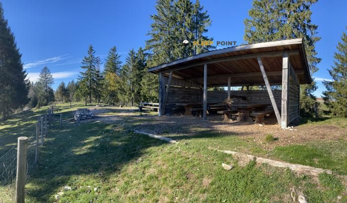
Cabane du Pierre-Pertuis It fits mainly as an intermediate point within walking tours of the Tavannes sector and the Montoz massif in the canton of Bern. At 1258 meters, it is located in a clear mountain within the Jura chain, above the Pierre Pertuis pass, which connects the Tavannes valley with that of Saint- Imier. That position is related to the string that links Montoz and the Montagne du Droit, more useful to progress through high forests and looms than as a high alpine mountain shelter.
The nearby network of trails reinforces that liaison role. In the area they pass local itineraries and also the Swiss route of E4 , so the cabin can be used to break down long days or to reorganize a journey between pastures, soft crests and forest steps of the Bernese Jura. The toponyms of Sous le Mont and Sentier Farron help to place it in a half-mountain environment with a mountain circulation, where the orientation depends more on correctly following the network of roads than on facing technical terrain.
The most clear orographic reference is Montoz , with 1328 meters and a little more than 4 kilometers, while elevations such as Sur la Rive, Montbetier or Les Craux complete a relief of rounded dorsal and valley changes. That is why, rather than the basis of demanding summits, this coat makes sense as logistical support on continuity routes, especially when linking sectors between Tavannes, Le Pichoux or Sornetan.
The day should be planned with autonomy. Although there are invented sources in the area, the nearest one is more than 3 kilometres away, so no immediate water should be available next to the shelter without prior verification. In a Jurasian cordial terrain, weather and fog can complicate the reading of the itinerary, even at moderate levels, and make it advisable to carry reliable mapping or layout.


Download the app and start looking for the shelter of your next adventure


Find a place to sleep before night falls.