Mountain refuge Cabane du Crêt Coquet
We have it listed in the app!
We have it listed in the app!


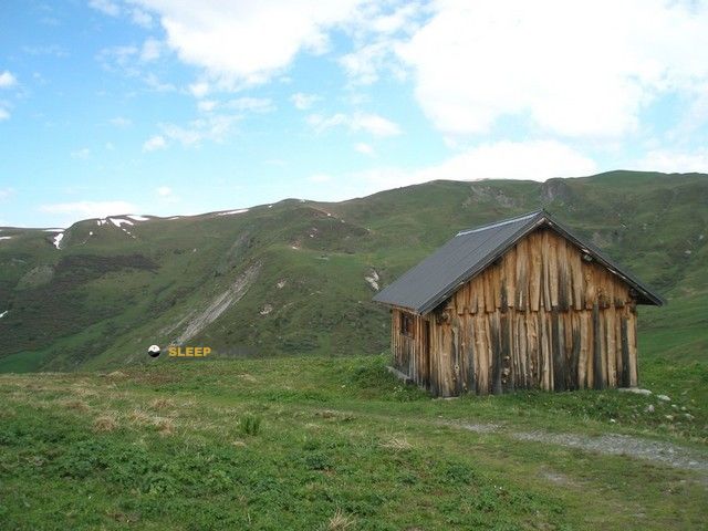
The Cabane du Crêt Coquet refuge stands at 1957 meters above sea level, overlooking the surroundings of crêt-coquet, route des alpages, hautecour, albertville, saboya, auvergne-rhône-alpes, francia metropolitana, 73600, francia. It is a key spot for mountaineers looking to spend the night or take a break. Its coordinates (45.534, 6.538) place it in a strategic position for exploring the peaks and trails of the region.
6°C
Feels like: 3.6°C2.9 km/h
Gusts: 13 km/h3990 m
Snow lineUV 0
Clouds: 91% 17.9 mm
 18.2 km/h
 UV máx: 5.4
 05:46
05:46
 21:17
2 mm
11.1 km/h
UV máx: 5.55
05:46
21:18
0 mm
13 km/h
UV máx: 7.6
05:46
21:19
0 mm
11.2 km/h
UV máx: 7.55
05:45
21:19
0.45 mm
13.8 km/h
UV máx: 7.05
05:45
21:20
5.7 mm
10.5 km/h
UV máx: 5.6
05:45
21:21
0 mm
9.7 km/h
UV máx: 7.5
05:44
21:21
21:17
2 mm
11.1 km/h
UV máx: 5.55
05:46
21:18
0 mm
13 km/h
UV máx: 7.6
05:46
21:19
0 mm
11.2 km/h
UV máx: 7.55
05:45
21:19
0.45 mm
13.8 km/h
UV máx: 7.05
05:45
21:20
5.7 mm
10.5 km/h
UV máx: 5.6
05:45
21:21
0 mm
9.7 km/h
UV máx: 7.5
05:44
21:21
At almost 2,000 meters, the Cabane du Crêt Coquet is left on the heights of Hautecour, in Savoy, on the route des alpages and in a relief of soft looms and tops that well marks the passage from the forest to the high pastures. This site helps to read it quickly on the map: it is not in a valley bottom or next to an inhabited core, but in an open strip, exposed to changing time and with a clearly mountainous environment, although without features of high glacial mountain.
The altitude conditions the use of the shelter. Even in relatively short exits, wind, fog, or a sudden change in temperature can weigh more than the pure level. In this sector of Auvergne-Rhône@-@ Alpes, the cabin fits better as support to travel the local mountain with autonomy than as an integrated stop on a large marked journey, as there are no specific close routes associated with the shelter. That is why it should be raised as a reference of land and protected within a day by crest, high pasture or near summits.
The most immediate top is Le Signal , a little more than half a kilometre, which reinforces your interest in moving around the nearby divide. Something further appears Le Quermoz and Roc Marchand , names that place the shelter in a mountain of wide orientation, with views and aspects changes rather than a closed circus. This relationship with several nearby elevations gives it meaning as a local basis for high-rise hiking or for linking short ascension in the area, always depending on the weather and the ability to navigate open terrain.
In the practical part, there is no need for immediate water next to the cabin: the nearest registered source is more than 2 kilometres away. That suggests going out with enough water and confirming on the ground any supply point. It is also reasonable to provide for complete autonomy and to consult recent information before going, especially if it is intended to be used outside the most stable season.


📏 0.6 Km
⛰️ 1825 m

📏 1.3 Km
⛰️ 1975 m

📏 1.3 Km
⛰️ 1700 m

📏 2.2 Km
⛰️ 1984 m

📏 4 Km
⛰️ 1920 m

📏 4.4 Km
⛰️ 1854 m
📏 4.7 Km
⛰️ 1960 m

📏 4.8 Km
⛰️ 1320 m
Download the app and start looking for the shelter of your next adventure


Find a place to sleep before night falls.


