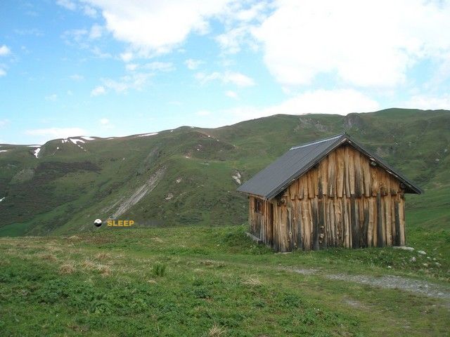
Mountain refuge La Cave
We have it listed in the app!
We have it listed in the app!


Strategically located in beauregard, chemin de planay, hautecour, albertville, saboya, auvergne-rhône-alpes, francia metropolitana, 73600, francia, the La Cave refuge makes exploring the area easier. At 1920 meters above sea level, this point of interest (45.569, 6.553) is a vital resource when planning your route.
7.4°C
Feels like: 4.4°C6.8 km/h
Gusts: 21.2 km/h3860 m
Snow lineUV 0
Clouds: 100% 18.8 mm
 21.7 km/h
 UV máx: 5.5
 05:46
05:46
 21:17
0.2 mm
10.9 km/h
UV máx: 6.05
05:46
21:18
0 mm
14.5 km/h
UV máx: 7.7
05:45
21:19
0 mm
11.2 km/h
UV máx: 7.7
05:45
21:19
0.3 mm
15.9 km/h
UV máx: 7.4
05:45
21:20
13.2 mm
12.8 km/h
UV máx: 1.1
05:44
21:21
0 mm
11.1 km/h
UV máx: 7.5
05:44
21:21
21:17
0.2 mm
10.9 km/h
UV máx: 6.05
05:46
21:18
0 mm
14.5 km/h
UV máx: 7.7
05:45
21:19
0 mm
11.2 km/h
UV máx: 7.7
05:45
21:19
0.3 mm
15.9 km/h
UV máx: 7.4
05:45
21:20
13.2 mm
12.8 km/h
UV máx: 1.1
05:44
21:21
0 mm
11.1 km/h
UV máx: 7.5
05:44
21:21
At 1,920 metres, in the Beauregard sector and over the Hautecour term, this coat fits better as a practical point of reference within the Saboyan mountain than as a simple isolated destination. The position places it in the area of passage between itineraries of the Beaufortain and Taretaise with interest for those who prepare a day with a map, need to divide a journey or look for an intermediate level before winning nearby peaks and summits.
The Cave appears linked to long-breath tours like the Tour du Beaufortain its variant and stages of Grand Tour de Tarentaise . That gives a clear idea of its role: not so much a valley-bottom shelter, but a high-mountain support where the orientation and management of the effort matter. In this type of terrain, small changes in the side or exposure can change the rate of progression, especially if the itinerary links high pastures, open loins and more stony sections.
With the available data, the water should not be taken for granted in the shelter itself. The nearest registered sources are more than 2.4 km away, so it is necessary to leave with sufficient autonomy and confirm before the route any reliable recharge point. At this altitude, in addition, wind and time changes can be quickly noticed, something to take into account if it is posed as a stop within a long day.
The immediate relief reinforces this mountain character without entering the glacier environment. Very close stand out Le Quermoz and Pointe du Dzonfié , while a little further the Pointe de Combe Bénite or Croix de Sécheron . More than a collection of tops, these names help to place La Cave on a ground of soft crest for frequent moments and orientation changes, useful for linking tours and reading the map well before moving.


📏 0.7 Km
⛰️ 1960 m

📏 1.3 Km
⛰️ 2200 m

📏 1.7 Km
⛰️ 2085 m

📏 1.9 Km
⛰️ 1984 m

📏 2.9 Km
⛰️ 1520 m

📏 3 Km
⛰️ 2200 m

📏 3 Km
⛰️ 1854 m

📏 3 Km
⛰️ 1700 m
Download the app and start looking for the shelter of your next adventure


Find a place to sleep before night falls.


