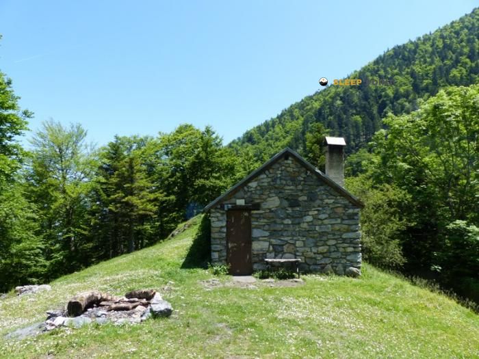
Mountain refuge Cabane de Plaede
We have it listed in the app!
We have it listed in the app!


At 1090 meters above sea level, nestled in cabane de plaede - luchonais, route forestière de la couage, juzet-d'izaut, saint-gaudens, alto garona, occitania, francia metropolitana, 31160, francia, stands the Cabane de Plaede refuge. It is the perfect stop to spend the night or catch your breath. GPS coordinates: 42.959, 0.775.
10.9°C
Feels like: 11.2°C1.3 km/h
Gusts: 1.1 km/h4000 m
Snow lineUV 1
Clouds: 96% 14.25 mm
 11.7 km/h
 UV máx: 3.45
 06:19
06:19
 21:31
0.4 mm
8.7 km/h
UV máx: 6.35
06:18
21:31
0.3 mm
8.1 km/h
UV máx: 7.25
06:18
21:32
2 mm
6.6 km/h
UV máx: 6.95
06:18
21:33
7.2 mm
9.4 km/h
UV máx: 6.55
06:18
21:33
9.9 mm
6 km/h
UV máx: 2.75
06:17
21:34
0 mm
8 km/h
UV máx: 7.5
06:17
21:35
21:31
0.4 mm
8.7 km/h
UV máx: 6.35
06:18
21:31
0.3 mm
8.1 km/h
UV máx: 7.25
06:18
21:32
2 mm
6.6 km/h
UV máx: 6.95
06:18
21:33
7.2 mm
9.4 km/h
UV máx: 6.55
06:18
21:33
9.9 mm
6 km/h
UV máx: 2.75
06:17
21:34
0 mm
8 km/h
UV máx: 7.5
06:17
21:35
On the side of the fight that ascends from Juzet-d'Izaut , by the route forestère de la Couage, this cabin is located at 1,090 meters in a half mountain strip that already forces to think about orientation and meteorology. It is not at the bottom of the valley or on fully alpine ground, but it is on a slope linked to the massif of the Pic de Cagire , where time changes can be noticed quickly and condition a day if it continues to higher levels.
Its mountain interest fits mainly in connection routes and itineraries that seek to divide the climb to the nearby summits or to better distribute a long access. In this sector, they appear as Chemin du Piémont Pyrénéen and the itinerary between Saint-Pé-d'Ardet and Bagnères-de-Luchon, so that the cabane can function as an intermediate reference within a broader planning, not as much as an isolated destination. It is also relatively close to Pique Poque Sommet , which reinforces its role as a support for the transition mountain terrain between forests, lomas and crest.
The exit should be considered with autonomy. The invented sources are not next to the shelter: the nearest one is more than 4 km away, a distance sufficient to not have immediate water without prior confirmation. There is also no data here on indoor equipment or conditions, so the practical decision goes by taking a basic use and preparing the day with a margin against cold, moisture or fog. In an area of forest access and increasingly open up, this prudence weighs more than the absolute altitude.


📏 1.4 Km
⛰️ 1355 m

📏 1.5 Km
⛰️ 1357 m

📏 1.5 Km
⛰️ 886 m

📏 2.9 Km
⛰️ 1470 m

📏 3 Km
⛰️ 1470 m

📏 3.3 Km
⛰️ 1210 m

📏 3.4 Km
⛰️ 1210 m

📏 4.5 Km
⛰️ 1598 m
Download the app and start looking for the shelter of your next adventure


Find a place to sleep before night falls.


