Mountain refuge Cabane de Juzet
We have it listed in the app!
We have it listed in the app!
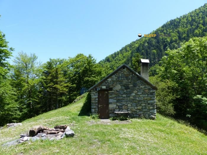

The Cabane de Juzet refuge acts as a base camp for the summits and routes of cabane de juzet, voie normale du cagire, juzet-d'izaut, saint-gaudens, alto garona, occitania, francia metropolitana, 31160, francia. At 1355 meters of elevation, its coordinates (42.953, 0.759) represent safety after a long day of effort.
11°C
Feels like: 9°C4.2 km/h
Gusts: 7.6 km/h4380 m
Snow lineUV 0
Clouds: 51% 15.4 mm
 17.9 km/h
 UV máx: 3.15
 06:19
06:19
 21:31
0 mm
13 km/h
UV máx: 6.9
06:19
21:31
0.8 mm
9.4 km/h
UV máx: 7.05
06:18
21:32
1.8 mm
6.8 km/h
UV máx: 6.9
06:18
21:33
7.2 mm
7.7 km/h
UV máx: 6.95
06:18
21:33
9.9 mm
9.3 km/h
UV máx: 2.9
06:17
21:34
0 mm
8 km/h
UV máx: 7.5
06:17
21:35
21:31
0 mm
13 km/h
UV máx: 6.9
06:19
21:31
0.8 mm
9.4 km/h
UV máx: 7.05
06:18
21:32
1.8 mm
6.8 km/h
UV máx: 6.9
06:18
21:33
7.2 mm
7.7 km/h
UV máx: 6.95
06:18
21:33
9.9 mm
9.3 km/h
UV máx: 2.9
06:17
21:34
0 mm
8 km/h
UV máx: 7.5
06:17
21:35
Cabane de Juchet is linked to the normal route of Pic de Cagire , and that already guides on its use: it does not work so much as a safe haven of comfortable passage of valley, but as support in a rise of medium mountain with continuity of slope and land that gains height quickly. At 1,355 meters, it is still in a forest or transition, but very close to the relief that form the Cagire itself and the Pique Poque Sommet , both within walking distance. This proximity makes it a useful reference for those who propose a day focused on the edge or on the ascension on the side of Juzet-d'Izaut.
In this area of the Comminges, at the foot of the Cagire massif, the shelter is somewhat removed from the main axes of the journey, although in the surroundings there are itineraries such as the Chemin du Piémont Pyrénéen and the Aran Pyrenees. Camino de Santiago . This means that it may have an interest as a detour or link for mountaineers who want to leave the main corridor and gain ground to higher levels, but it is appropriate to assess that rodeo according to the planned stage. It is not the same to use it as support for a concrete ascension than to incorporate it into a long path, where the orientation, the accumulated gap and the return to the main itinerary weigh more on planning.
The logistics side demands caution. The registered sources are not next to the shelter: the nearest one is more than 4 kilometres away, so immediate water is not appropriate in the vicinity. On a mountain such as the Cagire, with rapid time changes and sections exposed to the wind at higher levels, it makes sense to reach with sufficient autonomy and with the itinerary well closed before leaving. It is also a location that can interest more to those who seek a functional approach to nearby summits such as the Pic de l'Escalette that to those who need a frequent or highly supplied point of passage.


📏 0 Km
⛰️ 1357 m

📏 1.2 Km
⛰️ 886 m

📏 1.4 Km
⛰️ 1090 m

📏 2 Km
⛰️ 1210 m

📏 2 Km
⛰️ 1210 m

📏 2.1 Km
⛰️ 1470 m

📏 2.1 Km
⛰️ 1470 m

📏 3.3 Km
⛰️ 1380 m
Download the app and start looking for the shelter of your next adventure


Find a place to sleep before night falls.


