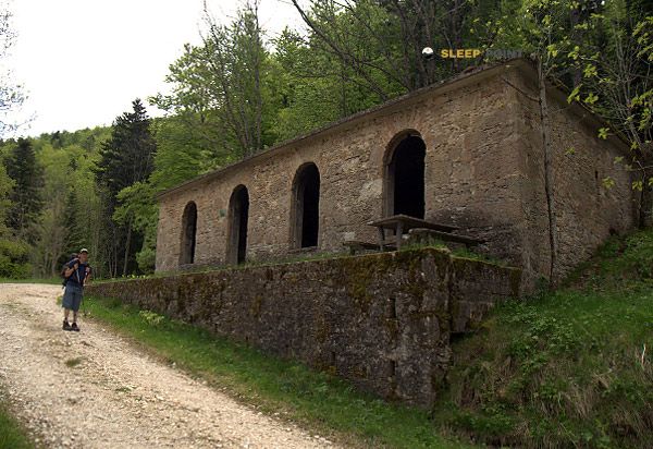
Mountain refuge Cabane de Marcel
We have it listed in the app!
We have it listed in the app!


The mountains of cabane chez marcel, route du maquis de la raye, ourches, valence, drôme, auvergne-rhône-alpes, francia metropolitana, 26120, francia hide essential places like the Cabane de Marcel refuge. Situated at an elevation of 815 meters, it offers protection and rest. Its exact coordinates are 44.795, 5.071.
14°C
Feels like: 11.2°C14.1 km/h
Gusts: 33.1 km/h4200 m
Snow lineUV 0
Clouds: 3% 30.6 mm
 27.2 km/h
 UV máx: 4.55
 05:55
05:55
 21:20
0 mm
31 km/h
UV máx: 6.95
05:55
21:21
0 mm
8.8 km/h
UV máx: 7.55
05:54
21:22
0 mm
15.8 km/h
UV máx: 7
05:54
21:22
0 mm
16.4 km/h
UV máx: 7.15
05:53
21:23
0.3 mm
22.3 km/h
UV máx: 6.45
05:53
21:24
0 mm
14.7 km/h
UV máx: 7.3
05:53
21:24
21:20
0 mm
31 km/h
UV máx: 6.95
05:55
21:21
0 mm
8.8 km/h
UV máx: 7.55
05:54
21:22
0 mm
15.8 km/h
UV máx: 7
05:54
21:22
0 mm
16.4 km/h
UV máx: 7.15
05:53
21:23
0.3 mm
22.3 km/h
UV máx: 6.45
05:53
21:24
0 mm
14.7 km/h
UV máx: 7.3
05:53
21:24
In the field of Ourches , inside the Drôme and on the edge of soft but open reliefs of the Raye , Cabane de Marcel It fits better as a walking coat than as an isolated destination in itself. Its height, 815 meters, places it in a half mountain where the forest, the lomas and the nearby cords mark more the orientation than the alpine environment. From here the articulation of the terrain between small heights and local steps is well understood, with close references such as the Raye or Tête Noire , useful for reading the relief and organizing tours in the area.
It also has an interest in travel routes: through this environment there are several stages of SPHC , so the cabin can be used to break the day, protect itself or even resolve a withdrawal if the time changes or the journey is longer than expected. It does not appear as a basis for great ascension, but it does appear as a logical support to move through these crest and nearby mountains, linking paths between slopes and divisives without the need to immediately go down to inhabited cores.
In the practical part it is appropriate to propose the exit with autonomy. There are water points in the environment, but the nearest one is about 2.5 km away, so it is not reasonable to have immediate supply next to the shelter. This distance, coupled with the lack of precise data on equipment or interior state, advises to carry sufficient water and logistical margin, especially if used as a point of passage in a long day. In a less extreme relief area but very exposed to plan changes, that detail weighs as much as the location itself.


Download the app and start looking for the shelter of your next adventure


Find a place to sleep before night falls.