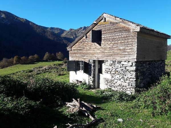
Mountain refuge Cabane de Ayzi
We have it listed in the app!
We have it listed in the app!


If you are looking for total disconnection, venture into cabane d'ayzi, sentier de peyrabibe, ost, agos-vidalos, argelès-gazost, altos pirineos, occitania, francia metropolitana, 65400, francia until you reach the Cabane de Ayzi refuge, positioned at 1218 meters. Use your device to navigate to the exact point (43.046, -0.088) to find this alpine shelter.
10.2°C
Feels like: 9.9°C6.5 km/h
Gusts: 14.8 km/h3580 m
Snow lineUV 0
Clouds: 100% 11.85 mm
 17.6 km/h
 UV máx: 1.3
 06:22
06:22
 21:35
0.2 mm
10.7 km/h
UV máx: 7.25
06:22
21:35
1.3 mm
10.3 km/h
UV máx: 6.55
06:21
21:36
0 mm
9.6 km/h
UV máx: 7.45
06:21
21:37
3.3 mm
10.6 km/h
UV máx: 3.05
06:21
21:37
3.6 mm
7.3 km/h
UV máx: 6.5
06:20
21:38
0 mm
9.1 km/h
UV máx: 7.45
06:20
21:38
21:35
0.2 mm
10.7 km/h
UV máx: 7.25
06:22
21:35
1.3 mm
10.3 km/h
UV máx: 6.55
06:21
21:36
0 mm
9.6 km/h
UV máx: 7.45
06:21
21:37
3.3 mm
10.6 km/h
UV máx: 3.05
06:21
21:37
3.6 mm
7.3 km/h
UV máx: 6.5
06:20
21:38
0 mm
9.1 km/h
UV máx: 7.45
06:20
21:38
On the hillside that links the surroundings of Agos-Vidalos and Ayzac-Ost, at 1218 meters, this cabin is located in a useful intermediate level for a day of mountain by half and prehigh mountain pirenaica. The nearby relief combines forest, flank trails and rounded elevations that, without entering the glacier or high altitude terrain, do require reading of the terrain, continuity of passage and attention to the time changes of the Pyrenees.
The Cabane de Ayzi is left in Occitania, within the Argelès-Gazost sector, in an area where long-distance paths and local links converge. The proximity of the GR 782 and GR 101 strengthens its role as a walking coat or as a support to divide a journey without going down to the bottom of the valley. More than an isolated destination, it works as a point of orientation within a network of roads that communicates slopes and villages of the Pyrenees.
Access must be considered by mountain criteria, especially if it is carried with material or with unstable weather. The altitude is not extreme, but is sufficient to notice moisture, wind or fog depending on the season. It is necessary to leave with basic autonomy and without immediate water next to the shelter: the nearest registered sources are more than 2.5 km away, so it is better to ensure the supply before the rise.
In the immediate environment, the peaks appear as La Serre , Soum de Mont Né or Soum du Prat d'Aureilh , which help to understand the character of the place: ground of crests and lomas with short but sustained levels, suitable to link local orientation routes or to gain height over the valley. It can also serve as a reference in routes to the Pic du Pibeste where hiking already calls for a more attentive progression.


📏 0.9 Km
⛰️ 1310 m

📏 3.7 Km
⛰️ 1224 m

📏 3.7 Km
⛰️ 1220 m

📏 5.9 Km
⛰️ 1440 m

📏 6.1 Km
⛰️ 939 m

📏 6.6 Km
⛰️ 1159 m

📏 7.3 Km
⛰️ 1630 m
📏 9 Km
⛰️ 1300 m
Download the app and start looking for the shelter of your next adventure


Find a place to sleep before night falls.


