Mountain refuge Cabane Yerse / Espadre
We have it listed in the app!
We have it listed in the app!
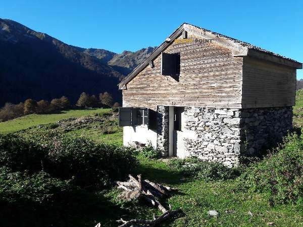

If you are looking for total disconnection, venture into cabane de yerse, sentier des liots, asson, pau, pyrénées-atlantiques, nueva aquitania, francia metropolitana, 64800, francia until you reach the Cabane Yerse / Espadre refuge, positioned at 1300 meters. Use your device to navigate to the exact point (43.049, -0.199) to find this alpine shelter.
11.6°C
Feels like: 9.1°C3.6 km/h
Gusts: 9.4 km/h4230 m
Snow lineUV 0
Clouds: 54% 16.98 mm
 18.6 km/h
 UV máx: 1.65
 06:22
06:22
 21:35
0 mm
8.8 km/h
UV máx: 7.45
06:22
21:36
0.8 mm
8.2 km/h
UV máx: 5.7
06:22
21:36
0 mm
9.2 km/h
UV máx: 7.55
06:21
21:37
4.2 mm
8.5 km/h
UV máx: 3.05
06:21
21:38
1.8 mm
6.6 km/h
UV máx: 5.85
06:21
21:38
0 mm
7.9 km/h
UV máx: 7.45
06:21
21:39
21:35
0 mm
8.8 km/h
UV máx: 7.45
06:22
21:36
0.8 mm
8.2 km/h
UV máx: 5.7
06:22
21:36
0 mm
9.2 km/h
UV máx: 7.55
06:21
21:37
4.2 mm
8.5 km/h
UV máx: 3.05
06:21
21:38
1.8 mm
6.6 km/h
UV máx: 5.85
06:21
21:38
0 mm
7.9 km/h
UV máx: 7.45
06:21
21:39
In this sector of Asson on the French side of the Western Pyrenees, the Cabane Yerse / Esfather it fits better as a shelter of passage than as an isolated destination in itself. Its position, about 1300 meters away, places it in a half-mountain high strip where time changes are quickly noticed and where the terrain can alternate thighs, essatives and crest or link sections between cords. This combination makes it useful for those who move on long routes or seek a reasonable withdrawal before losing much height.
The clearest reference in the area is the GR 101 , the Chemin de l'Ouest de Bigorre, which gives context to its function within a long journey. In addition, local routes such as Les Estives de l'Aoulhet, L'Isarce et les Crêtes or Le Sentier du Pladi, signs of a network of roads that allows to link days, vary the route or reorganize the route according to the weather, are around. It is not appropriate to interpret this as a simple ground: the orientation between secondary and mountain paths may require attention, especially if you enter or leave the shelter with limited visibility.
It may also have an interest as a short basis for moving to nearby reliefs. The immediate environment is dominated by modest but close elevations, such as Marti Peyras , which help to understand the character of the place: not so much a refuge of high alpine altitude, but a support to travel crest, hills and rounded tops of the area. For mountaineers who chain secondary ascendations, cross-fences or recognition days, their location is more practical than a complete descent to the bottom of the valley.
From a logistical point of view, it is appropriate to propose the exit with autonomy. The nearest registered source is more than 3 kilometres away, so it is not wise to have immediate water in the shelter environment. No specific equipment or services should be taken for granted, so that planning should be based on its own material, weather forecast and sufficient scope for travel changes.
By use profile, this point fits better with hiking and mountaineers used to open-ground days, with the ability to read the map and adapt the march. In an area with several possible itineraries, the cabane functions mainly as intermediate support, as a link between the routes of the Bigorre sector and as an escape option if the journey forces to cut stage before time.


📏 1.2 Km
⛰️ 1393 m

📏 3.2 Km
⛰️ 1285 m

📏 3.2 Km
⛰️ 1285 m

📏 3.3 Km
⛰️ 1159 m

📏 3.4 Km
⛰️ 1400 m

📏 3.6 Km
⛰️ 1440 m

📏 4 Km
⛰️ 1350 m

📏 5.3 Km
⛰️ 1224 m
Download the app and start looking for the shelter of your next adventure


Find a place to sleep before night falls.


