Mountain refuge Rifugio Fontana Mura
We have it listed in the app!
We have it listed in the app!
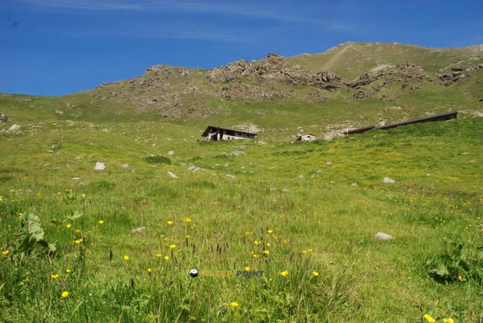

The Rifugio Fontana Mura refuge (rifugio fontana mura, rocca nalais, serre la croce, perosa argentina, turín, piamonte, 10063, italia) is a classic meeting point for mountaineers and hikers. At 1726 meters, its coordinates 45.018, 7.187 mark the end of a stage or the beginning of a new adventure.
11.9°C
Feels like: 9.3°C6.5 km/h
Gusts: 23 km/h4100 m
Snow lineUV 0
Clouds: 92% 10.9 mm
 22.7 km/h
 UV máx: 4.35
 05:46
05:46
 21:12
0 mm
20.8 km/h
UV máx: 6.95
05:45
21:13
0 mm
11.2 km/h
UV máx: 5.1
05:45
21:14
0.6 mm
10.4 km/h
UV máx: 7.2
05:45
21:15
6.15 mm
9.6 km/h
UV máx: 7.55
05:44
21:15
0 mm
12.2 km/h
UV máx: 7
05:44
21:16
0 mm
13.1 km/h
UV máx: 4.1
05:44
21:17
21:12
0 mm
20.8 km/h
UV máx: 6.95
05:45
21:13
0 mm
11.2 km/h
UV máx: 5.1
05:45
21:14
0.6 mm
10.4 km/h
UV máx: 7.2
05:45
21:15
6.15 mm
9.6 km/h
UV máx: 7.55
05:44
21:15
0 mm
12.2 km/h
UV máx: 7
05:44
21:16
0 mm
13.1 km/h
UV máx: 4.1
05:44
21:17
At 1,726 metres, Rifugio Fontana Mura appears in a half-high mountain strip where the terrain already works as a hinge between slopes, cords and small side changes. The reference of Rocca Nalais and Serre la Croce places it above the inhabited area of Perosa Argentina in the environment of Chisone Valley , an area where the orientation and continuity of the itinerary weigh more than the simple proximity to the valley. There is not much detail about the shelter, so you should understand it first and foremost as basic mountain support and not as a point with known services.
His position gains interest in the relief surrounding him. In a relatively close radio there are summits such as Monte Rocciavré , Punta Cristalliera or Punta Costabruna , in addition to secondary elevations that help draw a ground of crest and linked lomas. This suggests a practical use for passing days, links between mountain sectors or approaches that seek to divide the effort before entering higher levels. More than an ascension base with closed information, it fits as an intermediate reference within routes that change from basin or seek continuity through the divisive.
It also weighs its relationship with marked long and half-way itineraries. The Sentiero dei Franchi and several stages of Sentieri della Resistenza , which reinforces this mountain shelter function in a mountain and mountain traffic corral. As the distances of these routes are variable in the available data, it is reasonable to read this point as a possible link within wider routes, not as an end or unique start of a specific excursion.
In the logistics part, there is a very close source, about 24 meters away, and other distributed in the immediate environment, something useful in an area where autonomy remains important. However, in the mountains it is appropriate to provide for changes in flow, seasonality and need for potification. The altitude, exposure to time and lack of detailed information on conditions of use make it advisable to arrive with own planning, especially if it is intended to link necklaces, crest or several stages followed by this sector of the Piedmont.


📏 3.1 Km
⛰️ 2679 m

📏 5.5 Km
⛰️ 2274 m

📏 6.2 Km
⛰️ 2023 m

📏 8 Km
⛰️ 1710 m

📏 9.6 Km
⛰️ 1931 m

📏 9.6 Km
⛰️ 1385 m

📏 17.3 Km
⛰️ 2785 m

📏 19 Km
⛰️ 1706 m
Download the app and start looking for the shelter of your next adventure


Find a place to sleep before night falls.


