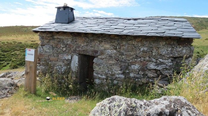
Mountain refuge Refugio de montaña de Cárdena
We have it listed in the app!
We have it listed in the app!


Discover the vastness of refugio de montaña de cárdena, plano inclinado, moncabril, galende, zamora, castilla y león, 49362, españa by spending the night at the Refugio de montaña de Cárdena refuge. It sits at 1531 meters, offering a unique balcony over the natural landscape. Find it on the map at latitude 42.129 and longitude -6.791.
9.9°C
Feels like: 6.9°C15.3 km/h
Gusts: 47.2 km/h4520 m
Snow lineUV 0
Clouds: 89% 0 mm
0 mm
 23.5 km/h
 UV máx: 8.1
 06:52
06:52
 21:58
0 mm
17.3 km/h
UV máx: 7.85
06:52
21:59
0 mm
14.7 km/h
UV máx: 8.15
06:51
22:00
0 mm
12.9 km/h
UV máx: 7.7
06:51
22:00
0 mm
18.8 km/h
UV máx: 8.35
06:51
22:01
0 mm
8.9 km/h
UV máx: 7.95
06:51
22:01
0 mm
10.1 km/h
UV máx: 7.95
06:50
22:02
21:58
0 mm
17.3 km/h
UV máx: 7.85
06:52
21:59
0 mm
14.7 km/h
UV máx: 8.15
06:51
22:00
0 mm
12.9 km/h
UV máx: 7.7
06:51
22:00
0 mm
18.8 km/h
UV máx: 8.35
06:51
22:01
0 mm
8.9 km/h
UV máx: 7.95
06:51
22:01
0 mm
10.1 km/h
UV máx: 7.95
06:50
22:02
The rise by the Cárdena cannons defines access to this sector. The relief becomes abrupt from Moncabril, quickly gaining height towards the area of the so-called tilted plane in the municipality of Galende. In this environment of the Sanabresa mountain, the terrain alternates granite canchales and low shrubs, demanding a precise orientation capacity on the map. The progression to the level of a thousand five hundred meters reveals a landscape modeled by the glacial erosion, where the naked rock dominates the visual horizon of the mountain.
The location at an altitude of 1531 meters exposes the structure to the changing weather conditions of the Sierra de la Segundera. The Atlantic influence in this sector of Castilla and León can generate sudden thermal decreases and persistent fog that complicate visibility. Under this prism, the Cárdena Mountain Refuge it takes a strategic advantage as a preventive shelter point or place of passage during the Senda de los Cañones del Cárdena and Segundera. Its position makes it possible to better manage the passing times before facing the levels that lead to the upper massif platforms.
The logistics in this area requires a rigorous planning focused on the autonomy of the mountain. Immediate water availability in the direct environment should not be available, as the nearest supply points are located more than three kilometres away by broken ground. The absence of guaranteed services requires the senderist to carry all the necessary material for the stay and the food. It is essential to understand this space as a basic support resource, ideal for fractionating long-range stages but dependent on the user's technical preparation.
The geographical context links this point to relevant summits such as the Pico del Fraile , located just over a mile away, and the Peña Resbalada. To the north-east, the relief extends to the Alto del Salto and Peña del Buey, forming an orographic knot that dominates the side of the Truchas River. The connection with itineraries such as the Senda de la Rota Dam or the proximity to the Cañón del Tera reinforces its role as a link between the Ribadelago valley and the high plains of the saw. Its function as a point of withdrawal is critical to any eventuality on the routes that connect with the Laguna de Sotillo.


📏 1 Km
⛰️ 1602 m

📏 1.8 Km
⛰️ 1576 m

📏 3.9 Km
⛰️ 1466 m

📏 4.9 Km
⛰️ 1766 m

📏 5.1 Km
⛰️ 1304 m

📏 5.2 Km
⛰️ 1815 m
📏 5.2 Km
⛰️ 1610 m

📏 5.5 Km
⛰️ 1534 m
Download the app and start looking for the shelter of your next adventure


Find a place to sleep before night falls.


